STS062-152-246
| NASA Photo ID | STS062-152-246 |
| Focal Length | 250mm |
| Date taken | 1994.03.10 |
| Time taken | 17:56:31 GMT |
Resolutions offered for this image:
5184 x 4096 pixels 640 x 505 pixels 640 x 480 pixels 5765 x 7318 pixels
5184 x 4096 pixels 640 x 505 pixels 640 x 480 pixels 5765 x 7318 pixels


Cloud masks available for this image:
Spacecraft nadir point: 31.3° N, 97.4° W
Photo center point: 31.5° N, 97.5° W
Photo center point by machine learning:
Photo center point: 31.5° N, 97.5° W
Photo center point by machine learning:
Nadir to Photo Center: North
Spacecraft Altitude: 161 nautical miles (298km)
Country or Geographic Name: | USA-TEXAS |
Features: | AUSTIN, WACO AREA, RESERVOIRS |
| Features Found Using Machine Learning: | |
Cloud Cover Percentage: | 0 (no clouds present) |
Sun Elevation Angle: | 53° |
Sun Azimuth: | 162° |
Camera: | Linhof |
Focal Length: | 250mm |
Camera Tilt: | 5 degrees |
Format: | 5046: Kodak, natural color positive, Lumiere 100/5046, ASA 100, standard base |
Film Exposure: | Normal |
| Additional Information | |
| Width | Height | Annotated | Cropped | Purpose | Links |
|---|---|---|---|---|---|
| 5184 pixels | 4096 pixels | No | No | Earth From Space collection | Download Image |
| 640 pixels | 505 pixels | No | No | Earth From Space collection | Download Image |
| 640 pixels | 480 pixels | No | No | ISD 1 | Download Image |
| 5765 pixels | 7318 pixels | Download Image |
Download Packaged File
Download a Google Earth KML for this Image
View photo footprint information
Download a GeoTIFF for this photo
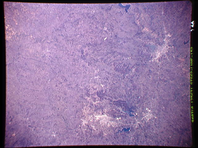
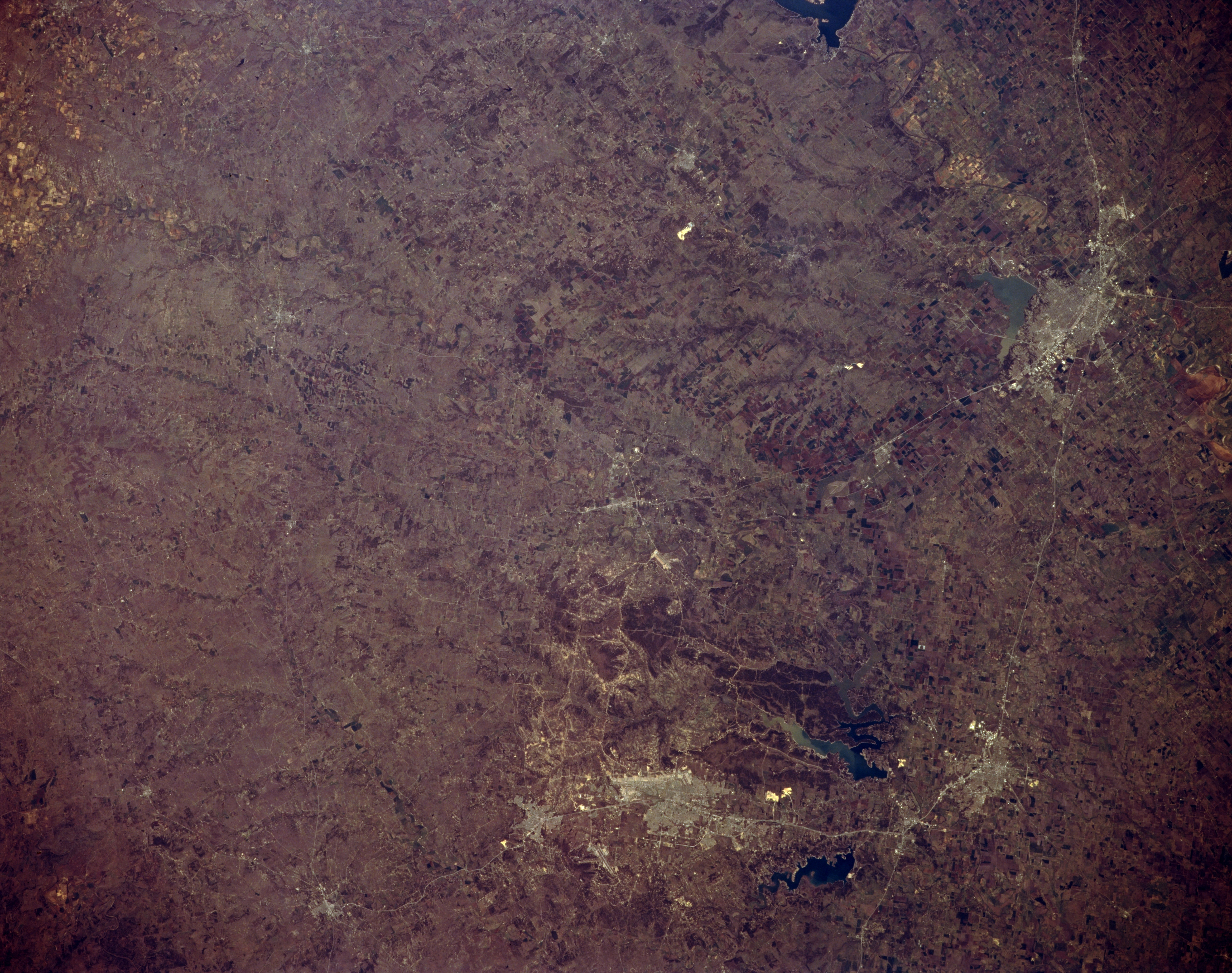
Image Caption: STS062-152-246 Waco and Killeen, Texas, U.S.A. March 1994
Cities, connecting highways, large reservoirs, and diverse landscapes are featured in this synoptic photograph of central Texas. Urban areas are not clearly discernible; however, lighter colors denote the locations and sizes of various cities. Interstate Highway 35 connects from north to south Waco, Temple, and Belton, (right side of photograph). Circling clockwise to the northwest from Belton are Killeen with Fort Hood to its north and west, Copperas Cove, Lampasas, and Gatesville. Viewing from north to south are several reservoirs--the southern end of Lake Whitney, Lake Waco, Belton Lake, and Stillhouse Hollow Lake. Interstate Highway 35 is roughly the dividing line between the relatively flat terrain of the Grand Prairie to the east and the hills and uplifted plateaus, such as the Comanche Plateau and the Lampasas Cut Plains, to the west.
Cities, connecting highways, large reservoirs, and diverse landscapes are featured in this synoptic photograph of central Texas. Urban areas are not clearly discernible; however, lighter colors denote the locations and sizes of various cities. Interstate Highway 35 connects from north to south Waco, Temple, and Belton, (right side of photograph). Circling clockwise to the northwest from Belton are Killeen with Fort Hood to its north and west, Copperas Cove, Lampasas, and Gatesville. Viewing from north to south are several reservoirs--the southern end of Lake Whitney, Lake Waco, Belton Lake, and Stillhouse Hollow Lake. Interstate Highway 35 is roughly the dividing line between the relatively flat terrain of the Grand Prairie to the east and the hills and uplifted plateaus, such as the Comanche Plateau and the Lampasas Cut Plains, to the west.
