STS062-151-52
| NASA Photo ID | STS062-151-52 |
| Focal Length | 90mm |
| Date taken | 1994.03.05 |
| Time taken | 17:11:01 GMT |
Resolutions offered for this image:
640 x 480 pixels
640 x 480 pixels
Cloud masks available for this image:
Spacecraft nadir point: 37.2° N, 110.8° W
Photo center point: 37.0° N, 111.0° W
Photo center point by machine learning:
Photo center point: 37.0° N, 111.0° W
Photo center point by machine learning:
Nadir to Photo Center: Southwest
Spacecraft Altitude: 161 nautical miles (298km)
Country or Geographic Name: | USA-UTAH |
Features: | GRAND CANYON, L. POWELL |
| Features Found Using Machine Learning: | |
Cloud Cover Percentage: | 20 (11-25)% |
Sun Elevation Angle: | 35° |
Sun Azimuth: | 134° |
Camera: | Linhof |
Focal Length: | 90mm |
Camera Tilt: | 6 degrees |
Format: | 5048: Kodak, natural color positive, Lumiere 100x/5048, ASA 100x, standard base |
Film Exposure: | Normal |
| Additional Information | |
| Width | Height | Annotated | Cropped | Purpose | Links |
|---|---|---|---|---|---|
| 640 pixels | 480 pixels | No | No | ISD 1 | Download Image |
Download Packaged File
Download a Google Earth KML for this Image
View photo footprint information
Download a GeoTIFF for this photo
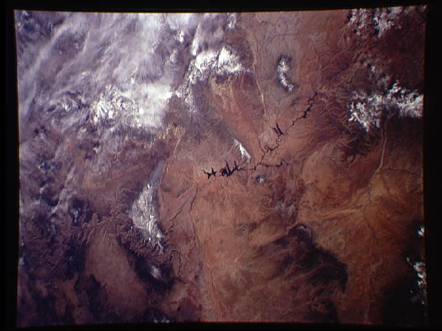
Image Caption: In this view, the Colorado River can be seen flowing southwest from top left to bottom center-right. The dark wider sections of the river are the water surface of Lake Powell (center, and top left), 110 miles long in a straight line. Grand Canyon National Monument lies lower right, centered on the Grand Canyon of the Colorado River, a 10 mile-wide gash carved more than 5,000 feet deep by the Colorado. The Canyon has cut into the Kaibab Plateau, an uplifted area visible here as a forested area with snow on the highest northern parts. The surrounding parts of the Colorado Plateau are sparsely occupied by brush vegetation and appear yellow-brown. The dark area top right is the wooded country of Black Mesa in Navajoland, divided from Lake Powell by the San Juan River. Four Corners is just outside the pictures (top) where the states of Arizona, Utah, Colorado and New Mexico meet. The Henry Mountains appear top left. Apart from Grand Canyon National Monument, several other famous national mo
