STS062-151-30
| NASA Photo ID | STS062-151-30 |
| Focal Length | 90mm |
| Date taken | 1994.03.05 |
| Time taken | 14:07:48 GMT |

Cloud masks available for this image:
Spacecraft nadir point: 34.5° N, 75.3° W
Photo center point: 35.0° N, 76.0° W
Photo center point by machine learning:
Photo center point: 35.0° N, 76.0° W
Photo center point by machine learning:
Nadir to Photo Center: Northwest
Spacecraft Altitude: 161 nautical miles (298km)
Country or Geographic Name: | USA-NORTH CAROLINA |
Features: | CAPES LOOKOUT & HATTERAS |
| Features Found Using Machine Learning: | |
Cloud Cover Percentage: | 15 (11-25)% |
Sun Elevation Angle: | 31° |
Sun Azimuth: | 123° |
Camera: | Linhof |
Focal Length: | 90mm |
Camera Tilt: | 18 degrees |
Format: | 5048: Kodak, natural color positive, Lumiere 100x/5048, ASA 100x, standard base |
Film Exposure: | Normal |
| Additional Information | |
| Width | Height | Annotated | Cropped | Purpose | Links |
|---|---|---|---|---|---|
| 5184 pixels | 4064 pixels | No | No | Earth From Space collection | Download Image |
| 640 pixels | 501 pixels | No | No | Earth From Space collection | Download Image |
| 640 pixels | 480 pixels | No | No | ISD 1 | Download Image |
Download Packaged File
Download a Google Earth KML for this Image
View photo footprint information
Download a GeoTIFF for this photo
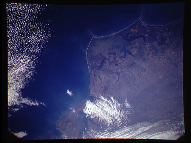
Image Caption: STS062-151-030 Pamlico Sound Area, North Carolina, U.S.A. March 1994
The small scale of this northwest looking image allows the viewing of two river basins that creates most of the wetlands along the North Carolina coast. Several sediment-rich river tributaries are visible as they flow into Pamlico Sound, the large, muddy embayment west of Cape Hatteras, and to a lesser extent into Albemarle Sound, the smaller estuary north of Pamlico Sound. The barrier islands extend from coastal Virginia to Cape Hatteras and Cape Lookout and beyond (southwest-bottom left). In addition to the coastal wetlands of North Carolina, some of the wetlands of Virginia and Maryland are visible, even as far north as Delaware Bay (top right). Unfortunately clouds mask the mouth of Chesapeake Bay.
The small scale of this northwest looking image allows the viewing of two river basins that creates most of the wetlands along the North Carolina coast. Several sediment-rich river tributaries are visible as they flow into Pamlico Sound, the large, muddy embayment west of Cape Hatteras, and to a lesser extent into Albemarle Sound, the smaller estuary north of Pamlico Sound. The barrier islands extend from coastal Virginia to Cape Hatteras and Cape Lookout and beyond (southwest-bottom left). In addition to the coastal wetlands of North Carolina, some of the wetlands of Virginia and Maryland are visible, even as far north as Delaware Bay (top right). Unfortunately clouds mask the mouth of Chesapeake Bay.
