STS061-75-22

| NASA Photo ID | STS061-75-22 |
| Focal Length | 40mm |
| Date taken | 1993.12.03 |
| Time taken | 08:00:38 GMT |
Resolutions offered for this image:
639 x 639 pixels 540 x 540 pixels 5266 x 5266 pixels 639 x 639 pixels 5700 x 6000 pixels 500 x 526 pixels 640 x 480 pixels
639 x 639 pixels 540 x 540 pixels 5266 x 5266 pixels 639 x 639 pixels 5700 x 6000 pixels 500 x 526 pixels 640 x 480 pixels


Cloud masks available for this image:
Spacecraft nadir point: 13.9° N, 14.6° E
Photo center point: 13.0° N, 14.5° E
Photo center point by machine learning:
Photo center point: 13.0° N, 14.5° E
Photo center point by machine learning:
Nadir to Photo Center: South
Spacecraft Altitude: 290 nautical miles (537km)
Camera: | Hasselblad |
Focal Length: | 40mm |
Camera Tilt: | 11 degrees |
Format: | 5017: Kodak, natural color positive, Ektachrome, X Professional, ASA 64, standard base |
Film Exposure: | Normal |
| Additional Information | |
| Width | Height | Annotated | Cropped | Purpose | Links |
|---|---|---|---|---|---|
| 639 pixels | 639 pixels | Photographic Highlights | Download Image | ||
| 540 pixels | 540 pixels | Photographic Highlights | Download Image | ||
| 5266 pixels | 5266 pixels | No | No | Earth From Space collection | Download Image |
| 639 pixels | 639 pixels | No | No | Earth From Space collection | Download Image |
| 5700 pixels | 6000 pixels | No | No | Download Image | |
| 500 pixels | 526 pixels | No | No | Download Image | |
| 640 pixels | 480 pixels | No | No | Download Image |
Download Packaged File
Download a Google Earth KML for this Image
View photo footprint information
Download a GeoTIFF for this photo
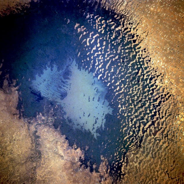
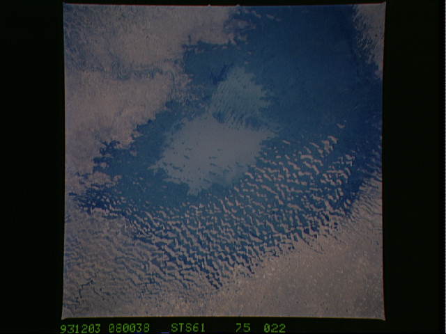
Image Caption: STS061-075-022 Lake Chad (South Basin), Chad December 1993
Lake Chad, which belongs to the countries of Chad, Cameroon, Nigeria, and Niger, is a sedimentary basin that is controlled by climate and rainfall. The lake is divided into two basins--the south basin fed by the Chari River and the north basin fed by the Komadougou River. The south basin, with its delta along the southern shore, has a distinct advantage in that the Sahel (a transition zone between the true desert and the grasslands south of the desert) generally receives more precipitation than the region west of Lake Chad that provides recharge water for the north basin. The south basin's water level has remained relatively constant during the decades of 1980s and 1990s, while the north basin has shown little evidence of standing water since the late 1960s and early 1970s. Extensive sand dunes exist within the northern half of the south basin, but there appears to be vegetation in this area. (Refer to STS-061-075-023 for a view of the north basin of Lake Chad.)
Lake Chad, which belongs to the countries of Chad, Cameroon, Nigeria, and Niger, is a sedimentary basin that is controlled by climate and rainfall. The lake is divided into two basins--the south basin fed by the Chari River and the north basin fed by the Komadougou River. The south basin, with its delta along the southern shore, has a distinct advantage in that the Sahel (a transition zone between the true desert and the grasslands south of the desert) generally receives more precipitation than the region west of Lake Chad that provides recharge water for the north basin. The south basin's water level has remained relatively constant during the decades of 1980s and 1990s, while the north basin has shown little evidence of standing water since the late 1960s and early 1970s. Extensive sand dunes exist within the northern half of the south basin, but there appears to be vegetation in this area. (Refer to STS-061-075-023 for a view of the north basin of Lake Chad.)
