STS060-92-14
| NASA Photo ID | STS060-92-14 |
| Focal Length | 100mm |
| Date taken | 1994.02.10 |
| Time taken | 22:06:17 GMT |
Resolutions offered for this image:
4008 x 4008 pixels 639 x 639 pixels 5700 x 5900 pixels 500 x 518 pixels 640 x 480 pixels 653 x 639 pixels
4008 x 4008 pixels 639 x 639 pixels 5700 x 5900 pixels 500 x 518 pixels 640 x 480 pixels 653 x 639 pixels


Cloud masks available for this image:
Spacecraft nadir point: 43.3° S, 72.0° W
Photo center point: 44.0° S, 73.0° W
Photo center point by machine learning:
Photo center point: 44.0° S, 73.0° W
Photo center point by machine learning:
Nadir to Photo Center: Southwest
Spacecraft Altitude: 193 nautical miles (357km)
Country or Geographic Name: | CHILE |
Features: | MOUNT MELIMOYU |
| Features Found Using Machine Learning: | |
Cloud Cover Percentage: | 0 (no clouds present) |
Sun Elevation Angle: | 20° |
Sun Azimuth: | 269° |
Camera: | Hasselblad |
Focal Length: | 100mm |
Camera Tilt: | 21 degrees |
Format: | 5017: Kodak, natural color positive, Ektachrome, X Professional, ASA 64, standard base |
Film Exposure: | Normal |
| Additional Information | |
| Width | Height | Annotated | Cropped | Purpose | Links |
|---|---|---|---|---|---|
| 4008 pixels | 4008 pixels | No | No | Earth From Space collection | Download Image |
| 639 pixels | 639 pixels | No | No | Earth From Space collection | Download Image |
| 5700 pixels | 5900 pixels | No | No | Download Image | |
| 500 pixels | 518 pixels | No | No | Download Image | |
| 640 pixels | 480 pixels | No | No | Download Image | |
| 653 pixels | 639 pixels | No | No | Download Image |
Download Packaged File
Download a Google Earth KML for this Image
View photo footprint information
Download a GeoTIFF for this photo
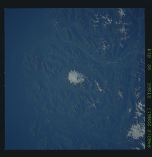
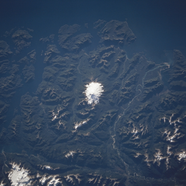
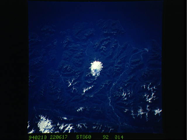
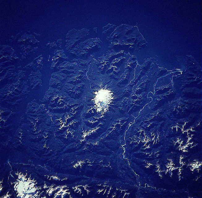
Image Caption: STS060-092-014 Mount Melimoyu, Chile February, 1994
The Glacier-capped peak of Mount Melimoyu is visible in this near-nadir looking view. A stratovolcano that last erupted 8000 to 11000 years ago, the mountain stands 7872 feet (2391 meters) high. Mount Melimoyu is surrounded by forested hills. The Muraleda Channel is visible to the west of the volcano covering the top portion of the image. The silt-laden meandering Palena River is discernible to the north of the volcano (right portion of the image). The Jacaf Strait is barely discernible to the south of the volcano at the left center of the image. The area around the volcano is sparsely populated.
The Glacier-capped peak of Mount Melimoyu is visible in this near-nadir looking view. A stratovolcano that last erupted 8000 to 11000 years ago, the mountain stands 7872 feet (2391 meters) high. Mount Melimoyu is surrounded by forested hills. The Muraleda Channel is visible to the west of the volcano covering the top portion of the image. The silt-laden meandering Palena River is discernible to the north of the volcano (right portion of the image). The Jacaf Strait is barely discernible to the south of the volcano at the left center of the image. The area around the volcano is sparsely populated.
