STS059-L09-162
| NASA Photo ID | STS059-L09-162 |
| Focal Length | 250mm |
| Date taken | 1994.04.10 |
| Time taken | 21:38:05 GMT |
Resolutions offered for this image:
640 x 480 pixels
640 x 480 pixels
Cloud masks available for this image:
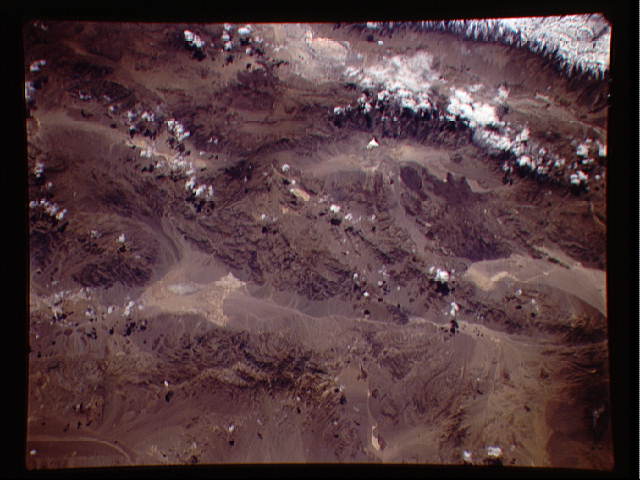
Spacecraft nadir point: 37.8° N, 116.5° W
Photo center point: 37.0° N, 117.5° W
Photo center point by machine learning:
Photo center point: 37.0° N, 117.5° W
Photo center point by machine learning:
Nadir to Photo Center: Southwest
Spacecraft Altitude: 119 nautical miles (220km)
Country or Geographic Name: | USA-CALIFORNIA |
Features: | MOUNTAINS, OWENS RIV & L. |
| Features Found Using Machine Learning: | |
Cloud Cover Percentage: | 10 (1-10)% |
Sun Elevation Angle: | 51° |
Sun Azimuth: | 227° |
Camera: | Linhof |
Focal Length: | 250mm |
Camera Tilt: | 33 degrees |
Format: | 5048: Kodak, natural color positive, Lumiere 100x/5048, ASA 100x, standard base |
Film Exposure: | Normal |
| Additional Information | |
| Width | Height | Annotated | Cropped | Purpose | Links |
|---|---|---|---|---|---|
| 640 pixels | 480 pixels | No | No | ISD 1 | Download Image |
Download Packaged File
Download a Google Earth KML for this Image
View photo footprint information
Download a GeoTIFF for this photo
Image Caption: This view is oriented with the snow-covered mountains (Sierra Nevada of California) in the upper right corner. Then Owens Valley runs along the top of the photograph to Owens Lake playa at top center. The upper end of Death Valley extends from right to left in the foreground, with the drainage running down to a playa of Stovepipe Wells in the left foreground. Geologists are studying microwave signatures of the different playa surfaces, and the coatings on alluvial fans that extend from mountain masses, to try to sort out the history of different climates in this formerly wet but now hyperarid region.
