STS059-75-66
| NASA Photo ID | STS059-75-66 |
| Focal Length | 250mm |
| Date taken | 1994.04.10 |
| Time taken | 11:06:41 GMT |
Resolutions offered for this image:
4054 x 4054 pixels 640 x 640 pixels 5700 x 5900 pixels 500 x 518 pixels 640 x 480 pixels
4054 x 4054 pixels 640 x 640 pixels 5700 x 5900 pixels 500 x 518 pixels 640 x 480 pixels


Cloud masks available for this image:
Spacecraft nadir point: 56.8° N, 6.5° W
Photo center point: 57.5° N, 7.5° W
Photo center point by machine learning:
Photo center point: 57.5° N, 7.5° W
Photo center point by machine learning:
Nadir to Photo Center: Northwest
Spacecraft Altitude: 117 nautical miles (217km)
Country or Geographic Name: | UK-SCOTLAND |
Features: | HERBRIDES, NORTH UIST |
| Features Found Using Machine Learning: | |
Cloud Cover Percentage: | 5 (1-10)% |
Sun Elevation Angle: | 39° |
Sun Azimuth: | 154° |
Camera: | Hasselblad |
Focal Length: | 250mm |
Camera Tilt: | 32 degrees |
Format: | 5046: Kodak, natural color positive, Lumiere 100/5046, ASA 100, standard base |
Film Exposure: | Normal |
| Additional Information | |
| Width | Height | Annotated | Cropped | Purpose | Links |
|---|---|---|---|---|---|
| 4054 pixels | 4054 pixels | No | No | Earth From Space collection | Download Image |
| 640 pixels | 640 pixels | No | No | Earth From Space collection | Download Image |
| 5700 pixels | 5900 pixels | No | No | Download Image | |
| 500 pixels | 518 pixels | No | No | Download Image | |
| 640 pixels | 480 pixels | No | No | Download Image |
Download Packaged File
Download a Google Earth KML for this Image
View photo footprint information
Download a GeoTIFF for this photo
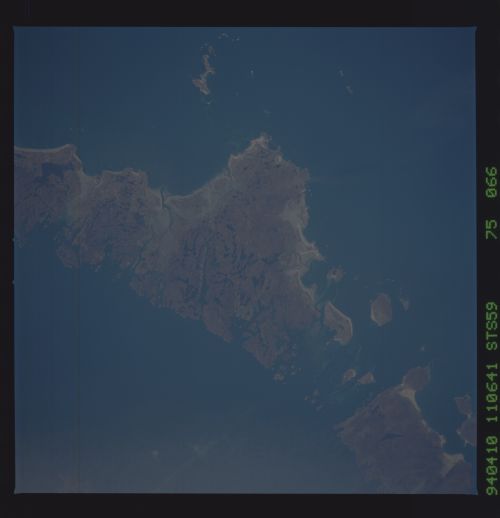
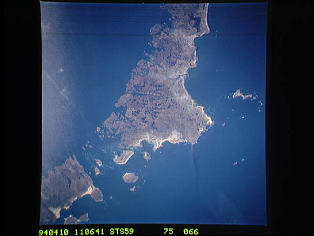
Image Caption: STS059-075-066 Outer Hebrides, Great Britain April, 1994
The rugged, hilly, glaciated Outer Hebrides (or Western Isles) Islands are visible in the mostly east-looking view. The islands have an indented coastline. Some fertile land on the western side of the islands does exist. The climate of the islands is harsh with cool temperatures and wet, stormy conditions. The islands are sparsely populated. The Little Minch (strait) covers the upper right portion of the image. Monach Island can be seen at the bottom of the image.
The rugged, hilly, glaciated Outer Hebrides (or Western Isles) Islands are visible in the mostly east-looking view. The islands have an indented coastline. Some fertile land on the western side of the islands does exist. The climate of the islands is harsh with cool temperatures and wet, stormy conditions. The islands are sparsely populated. The Little Minch (strait) covers the upper right portion of the image. Monach Island can be seen at the bottom of the image.
