STS059-204-69
| NASA Photo ID | STS059-204-69 |
| Focal Length | 40mm |
| Date taken | 1994.04.13 |
| Time taken | 10:11:46 GMT |
Resolutions offered for this image:
5700 x 5900 pixels 500 x 518 pixels 640 x 480 pixels 2545 x 2550 pixels
5700 x 5900 pixels 500 x 518 pixels 640 x 480 pixels 2545 x 2550 pixels


Cloud masks available for this image:
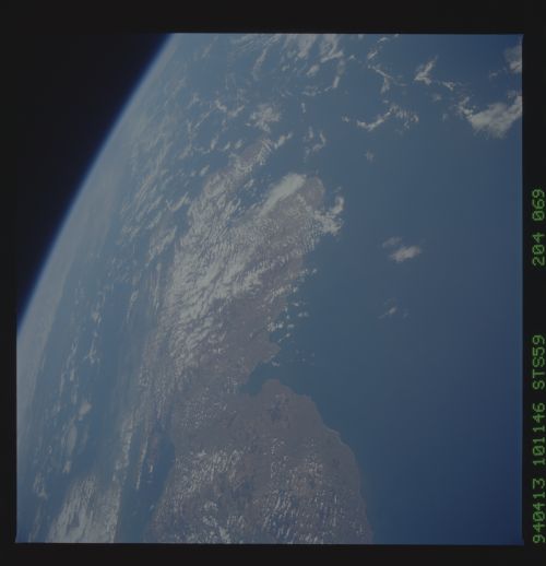
Spacecraft nadir point: 55.5° N, 0.3° E
Photo center point: 57.0° N, 1.0° W
Photo center point by machine learning:
Photo center point: 57.0° N, 1.0° W
Photo center point by machine learning:
Nadir to Photo Center: Northwest
Spacecraft Altitude: 116 nautical miles (215km)
Country or Geographic Name: | UK-SCOTLAND |
Features: | FIRTH OF FORTH, E COAST |
| Features Found Using Machine Learning: | |
Cloud Cover Percentage: | 10 (1-10)% |
Sun Elevation Angle: | 39° |
Sun Azimuth: | 145° |
Camera: | Hasselblad |
Focal Length: | 40mm |
Camera Tilt: | High Oblique |
Format: | 5048: Kodak, natural color positive, Lumiere 100x/5048, ASA 100x, standard base |
Film Exposure: | Normal |
| Additional Information | |
| Width | Height | Annotated | Cropped | Purpose | Links |
|---|---|---|---|---|---|
| 5700 pixels | 5900 pixels | No | No | Download Image | |
| 500 pixels | 518 pixels | No | No | Download Image | |
| 640 pixels | 480 pixels | No | No | Download Image | |
| 2545 pixels | 2550 pixels | Download Image |
Download Packaged File
Download a Google Earth KML for this Image
View photo footprint information
Download a GeoTIFF for this photo
Image Caption: none
