STS059-202-10
| NASA Photo ID | STS059-202-10 |
| Focal Length | 250mm |
| Date taken | 1994.04.11 |
| Time taken | 07:46:47 GMT |
Resolutions offered for this image:
4018 x 4018 pixels 639 x 639 pixels 5700 x 5900 pixels 500 x 518 pixels 640 x 480 pixels
4018 x 4018 pixels 639 x 639 pixels 5700 x 5900 pixels 500 x 518 pixels 640 x 480 pixels


Cloud masks available for this image:
Spacecraft nadir point: 55.7° N, 9.9° E
Photo center point: 57.0° N, 9.0° E
Photo center point by machine learning:
Photo center point: 57.0° N, 9.0° E
Photo center point by machine learning:
Nadir to Photo Center: Northwest
Spacecraft Altitude: 118 nautical miles (219km)
Country or Geographic Name: | DENMARK |
Features: | LIMSFJORDEN |
| Features Found Using Machine Learning: | |
Cloud Cover Percentage: | 0 (no clouds present) |
Sun Elevation Angle: | 27° |
Sun Azimuth: | 117° |
Camera: | Hasselblad |
Focal Length: | 250mm |
Camera Tilt: | 39 degrees |
Format: | 5048: Kodak, natural color positive, Lumiere 100x/5048, ASA 100x, standard base |
Film Exposure: | Normal |
| Additional Information | |
| Width | Height | Annotated | Cropped | Purpose | Links |
|---|---|---|---|---|---|
| 4018 pixels | 4018 pixels | No | No | Earth From Space collection | Download Image |
| 639 pixels | 639 pixels | No | No | Earth From Space collection | Download Image |
| 5700 pixels | 5900 pixels | No | No | Download Image | |
| 500 pixels | 518 pixels | No | No | Download Image | |
| 640 pixels | 480 pixels | No | No | Download Image |
Download Packaged File
Download a Google Earth KML for this Image
View photo footprint information
Download a GeoTIFF for this photo
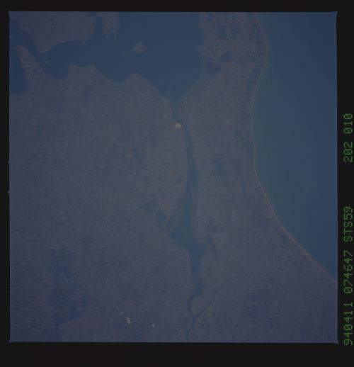
Image Caption: STS059-202-010 Lim Fjord, Denmark April 1994
A portion of Lim Fjord waterway can be seen in this north-looking view. The waterway is 110 miles (180 km) long and cuts across the northern Jutland Peninsula of Denmark eventually connecting the North Sea (not visible on the image) with the Kattegat (not visible on the image). The Lim Fjord is irregular in shape, forming the Logstor (left center), a lagoon 15 miles (24 km) wide, in its middle section. Jammer Bay is located along the upper left and center of the image.
A portion of Lim Fjord waterway can be seen in this north-looking view. The waterway is 110 miles (180 km) long and cuts across the northern Jutland Peninsula of Denmark eventually connecting the North Sea (not visible on the image) with the Kattegat (not visible on the image). The Lim Fjord is irregular in shape, forming the Logstor (left center), a lagoon 15 miles (24 km) wide, in its middle section. Jammer Bay is located along the upper left and center of the image.
