STS058-85-74
| NASA Photo ID | STS058-85-74 |
| Focal Length | 100mm |
| Date taken | 1993.10.__ |
| Time taken | GMT |
Resolutions offered for this image:
540 x 540 pixels 5700 x 5900 pixels 500 x 518 pixels 640 x 480 pixels 3391 x 3388 pixels 3388 x 3391 pixels 540 x 540 pixels
540 x 540 pixels 5700 x 5900 pixels 500 x 518 pixels 640 x 480 pixels 3391 x 3388 pixels 3388 x 3391 pixels 540 x 540 pixels


Cloud masks available for this image:
Spacecraft nadir point:
Photo center point: 42.5° N, 122.0° W
Photo center point by machine learning:
Photo center point: 42.5° N, 122.0° W
Photo center point by machine learning:
Nadir to Photo Center:
Spacecraft Altitude: nautical miles (0km)
Country or Geographic Name: | USA-OREGON |
Features: | KLAMATH BASIN |
| Features Found Using Machine Learning: | |
Cloud Cover Percentage: | 5 (1-10)% |
Sun Elevation Angle: | ° |
Sun Azimuth: | ° |
Camera: | Hasselblad |
Focal Length: | 100mm |
Camera Tilt: | Low Oblique |
Format: | 5017: Kodak, natural color positive, Ektachrome, X Professional, ASA 64, standard base |
Film Exposure: | Normal |
| Additional Information | |
| Width | Height | Annotated | Cropped | Purpose | Links |
|---|---|---|---|---|---|
| 540 pixels | 540 pixels | Yes | Yes | Earth From Space collection | Download Image |
| 5700 pixels | 5900 pixels | No | No | Download Image | |
| 500 pixels | 518 pixels | No | No | Download Image | |
| 640 pixels | 480 pixels | No | No | Download Image | |
| 3391 pixels | 3388 pixels | No | No | NASA's Earth Observatory web site | Download Image |
| 3388 pixels | 3391 pixels | Download Image | |||
| 540 pixels | 540 pixels | Yes | Yes | Photographic Highlights | Download Image |
Download Packaged File
Download a Google Earth KML for this Image
View photo footprint information
Download a GeoTIFF for this photo
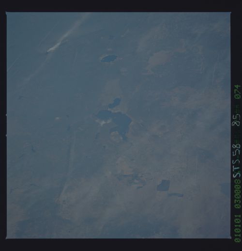
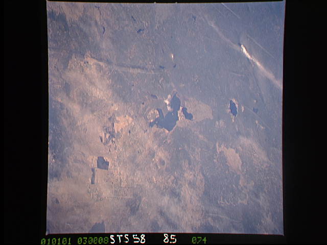
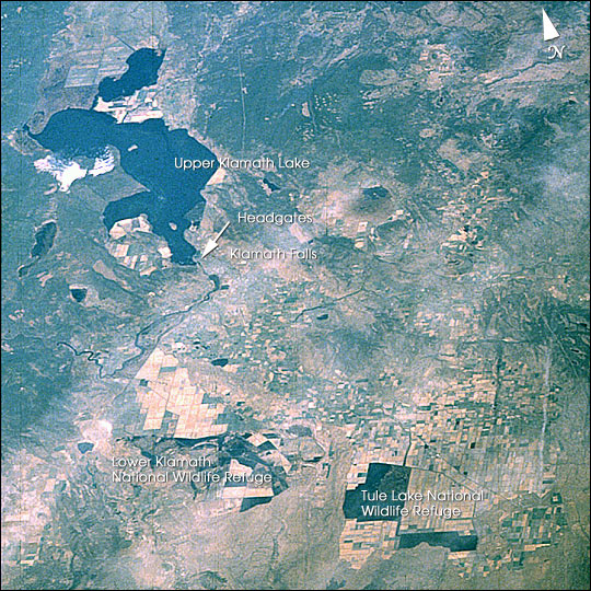
Image Caption: The Klamath Basin, on the California-Oregon border, has recently been in the news because of water shortages due to the ongoing drought in the United States' Pacific Northwest. Diverse interest groups have come into conflict over the limited availability of Klamath Project water this year. In order to protect endangered Sucker Fish and threatened Coho Salmon in Upper Klamath Lake, the U. S. Bureau of Reclamation cut off the flow of irrigation water to farmers in the project in April 2001. This action was supported by environmental groups, as well as commercial fisherman and Indian tribes that depend on Chinook Salmon. However, it also meant devastating losses for the farmers who require irrigation water from the Klamath Project, and potential adverse effects on wetland birds that rely on the Lower Klamath and Tule Lake marshes. Protests and civil disobedience by local farmers have focused on the project headgates at the south end of Upper Klamath Lake in the town of Klamath Falls. Citing a minor rise in the waters in Upper Klamath Lake, the Department of the Interior announced on July 25, 2001, that some water would be released to farmers.
This image shows the Klamath Basin in October 1993, as photographed by astronauts aboard the Space Shuttle. This year featured relatively normal conditions, although it followed immediately after a series of drought years. The larger square areas represent management units on the wildlife refuges; darker areas in the units are flooded. The smaller square areas are fields of irrigated agriculture.
This image shows the Klamath Basin in October 1993, as photographed by astronauts aboard the Space Shuttle. This year featured relatively normal conditions, although it followed immediately after a series of drought years. The larger square areas represent management units on the wildlife refuges; darker areas in the units are flooded. The smaller square areas are fields of irrigated agriculture.
