STS058-82-60
| NASA Photo ID | STS058-82-60 |
| Focal Length | 100mm |
| Date taken | 1993.10.30 |
| Time taken | 16:32:50 GMT |
Resolutions offered for this image:
3872 x 3872 pixels 639 x 639 pixels 5700 x 5900 pixels 500 x 518 pixels 640 x 480 pixels
3872 x 3872 pixels 639 x 639 pixels 5700 x 5900 pixels 500 x 518 pixels 640 x 480 pixels


Cloud masks available for this image:
Spacecraft nadir point: 35.1° N, 118.4° W
Photo center point: 36.5° N, 118.5° W
Photo center point by machine learning:
Photo center point: 36.5° N, 118.5° W
Photo center point by machine learning:
Nadir to Photo Center: North
Spacecraft Altitude: 143 nautical miles (265km)
Country or Geographic Name: | USA-CALIFORNIA |
Features: | SIERRA NEVADA MOUNTAINS |
| Features Found Using Machine Learning: | |
Cloud Cover Percentage: | 0 (no clouds present) |
Sun Elevation Angle: | 24° |
Sun Azimuth: | 130° |
Camera: | Hasselblad |
Focal Length: | 100mm |
Camera Tilt: | 30 degrees |
Format: | 5017: Kodak, natural color positive, Ektachrome, X Professional, ASA 64, standard base |
Film Exposure: | Normal |
| Additional Information | |
| Width | Height | Annotated | Cropped | Purpose | Links |
|---|---|---|---|---|---|
| 3872 pixels | 3872 pixels | No | No | Earth From Space collection | Download Image |
| 639 pixels | 639 pixels | No | No | Earth From Space collection | Download Image |
| 5700 pixels | 5900 pixels | No | No | Download Image | |
| 500 pixels | 518 pixels | No | No | Download Image | |
| 640 pixels | 480 pixels | No | No | Download Image |
Download Packaged File
Download a Google Earth KML for this Image
View photo footprint information
Download a GeoTIFF for this photo
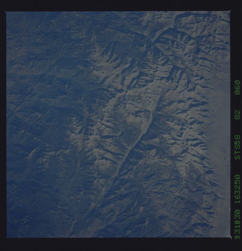
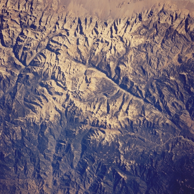
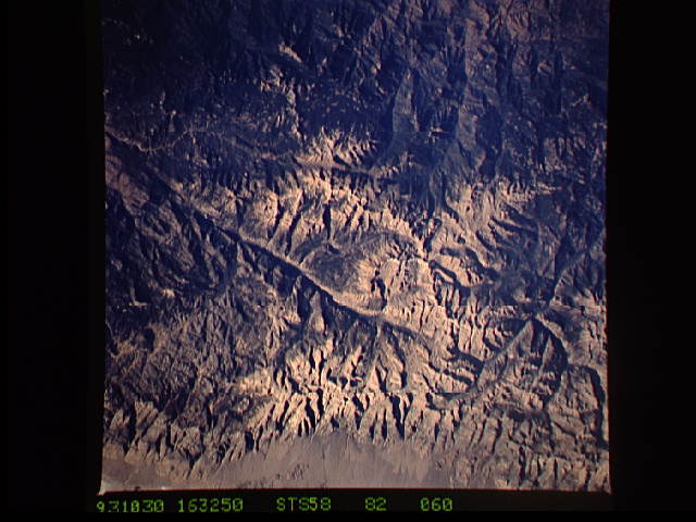
Image Caption: STS058-082-060 Mount Whitney and Sierra Nevada Mountains, California, U.S.A. October 1993
Mount Whitney [(14 491 feet) (4417 meters)], part of the snowcapped Sierra Nevada Mountains, is the highest peak in the contiguous 48 states. The sharp crest lines of the granite rocks are vivid evidence that these mountains were carved by past ice age glaciers. The north-south-aligned, U-shaped Kern River Valley, easily recognizable by the deep shadows cast on the valley walls, is actually a fault where glaciation further modified and produced a valley. The headwaters of Kings River Canyon, an east-west feature, lies north of the source for the Kern River.
Mount Whitney [(14 491 feet) (4417 meters)], part of the snowcapped Sierra Nevada Mountains, is the highest peak in the contiguous 48 states. The sharp crest lines of the granite rocks are vivid evidence that these mountains were carved by past ice age glaciers. The north-south-aligned, U-shaped Kern River Valley, easily recognizable by the deep shadows cast on the valley walls, is actually a fault where glaciation further modified and produced a valley. The headwaters of Kings River Canyon, an east-west feature, lies north of the source for the Kern River.
