STS058-74-10
| NASA Photo ID | STS058-74-10 |
| Focal Length | 100mm |
| Date taken | 1993.10.20 |
| Time taken | 03:02:45 GMT |
Resolutions offered for this image:
5303 x 5303 pixels 640 x 640 pixels 5700 x 5900 pixels 500 x 518 pixels 640 x 480 pixels
5303 x 5303 pixels 640 x 640 pixels 5700 x 5900 pixels 500 x 518 pixels 640 x 480 pixels


Cloud masks available for this image:
Spacecraft nadir point: 32.0° N, 95.0° E
Photo center point: 31.5° N, 88.0° E
Photo center point by machine learning:
Photo center point: 31.5° N, 88.0° E
Photo center point by machine learning:
Nadir to Photo Center: West
Spacecraft Altitude: 155 nautical miles (287km)
Country or Geographic Name: | CHINA |
Features: | PAN-TIBETAN PLAT, LAKES |
| Features Found Using Machine Learning: | |
Cloud Cover Percentage: | 0 (no clouds present) |
Sun Elevation Angle: | 36° |
Sun Azimuth: | 135° |
Camera: | Hasselblad |
Focal Length: | 100mm |
Camera Tilt: | High Oblique |
Format: | 5017: Kodak, natural color positive, Ektachrome, X Professional, ASA 64, standard base |
Film Exposure: | Normal |
| Additional Information | |
| Width | Height | Annotated | Cropped | Purpose | Links |
|---|---|---|---|---|---|
| 5303 pixels | 5303 pixels | No | No | Earth From Space collection | Download Image |
| 640 pixels | 640 pixels | No | No | Earth From Space collection | Download Image |
| 5700 pixels | 5900 pixels | No | No | Download Image | |
| 500 pixels | 518 pixels | No | No | Download Image | |
| 640 pixels | 480 pixels | No | No | Download Image |
Download Packaged File
Download a Google Earth KML for this Image
View photo footprint information
Download a GeoTIFF for this photo
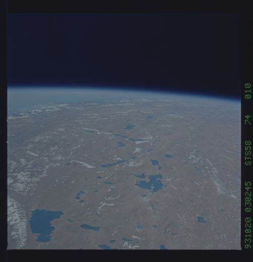
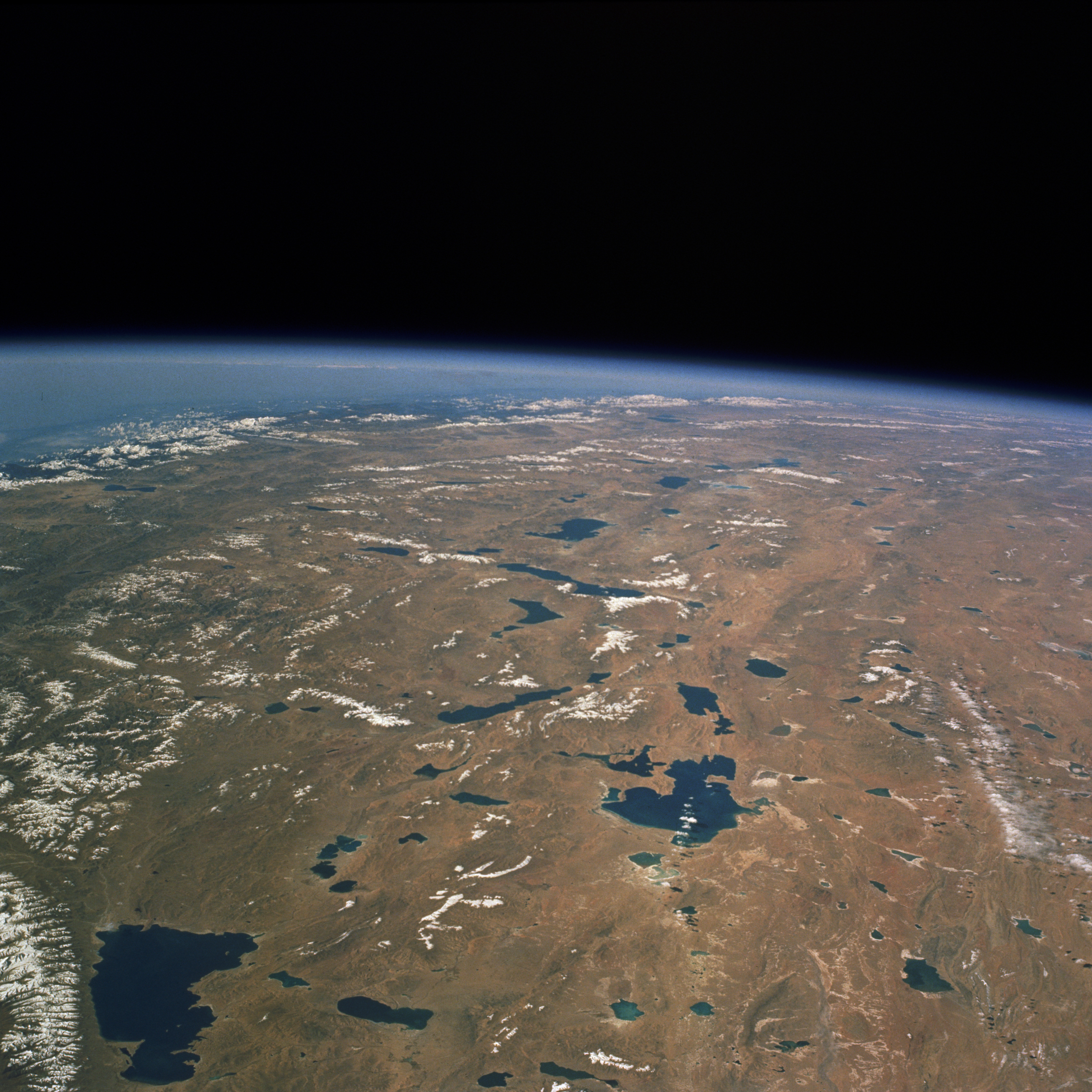
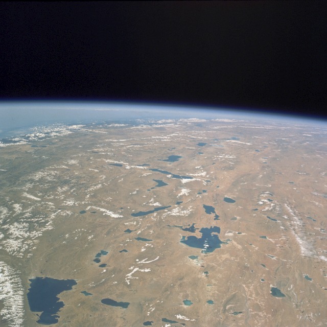
Image Caption: STS058-074-010 Tibetan Plateau, China October 1993
The southeast portion of the high Tibetan Plateau, called the Northern Plain by the Chinese, is seen in this southwest-looking, high-oblique photograph. The plateau, with elevations between 13 000 and 16 000 feet (4000 and 4900 meters), stretches for 800 miles (1300 kilometers) and is surrounded by massive mountain ranges. Many great rivers originate in the Tibetan Plateau--Indus, Brahmaputra, Sutlej, Salween, Mekong, Yangtze, and Yellow. The plateau has no river system; however, it has numerous brackish lakes, some of which are visible in this photograph. Saline Nam Co Lake (southeast corner of photograph), the largest lake in Tibet, covers 950 square miles (2461 square kilometers) and sits at an altitude of 15 180 feet (4630 meters). Although the plateau is a barren wasteland with virtually no trees or bushes, the light precipitation--averaging between 5 and 15 inches (125 and 380 centimeters) annually--does produce a summer grass crop that is vital for grazing. Some grain crops, primarily barley and buckwheat, are grown in the valleys. The Tibetan Plateau has large deposits of gold, copper, and radioactive ores, but mining is prohibited for religious reasons.
The southeast portion of the high Tibetan Plateau, called the Northern Plain by the Chinese, is seen in this southwest-looking, high-oblique photograph. The plateau, with elevations between 13 000 and 16 000 feet (4000 and 4900 meters), stretches for 800 miles (1300 kilometers) and is surrounded by massive mountain ranges. Many great rivers originate in the Tibetan Plateau--Indus, Brahmaputra, Sutlej, Salween, Mekong, Yangtze, and Yellow. The plateau has no river system; however, it has numerous brackish lakes, some of which are visible in this photograph. Saline Nam Co Lake (southeast corner of photograph), the largest lake in Tibet, covers 950 square miles (2461 square kilometers) and sits at an altitude of 15 180 feet (4630 meters). Although the plateau is a barren wasteland with virtually no trees or bushes, the light precipitation--averaging between 5 and 15 inches (125 and 380 centimeters) annually--does produce a summer grass crop that is vital for grazing. Some grain crops, primarily barley and buckwheat, are grown in the valleys. The Tibetan Plateau has large deposits of gold, copper, and radioactive ores, but mining is prohibited for religious reasons.
