STS058-111-84

| NASA Photo ID | STS058-111-84 |
| Focal Length | 250mm |
| Date taken | 1993.10.21 |
| Time taken | 00:03:04 GMT |
Resolutions offered for this image:
5266 x 5214 pixels 639 x 633 pixels 5700 x 5900 pixels 500 x 518 pixels 640 x 480 pixels
5266 x 5214 pixels 639 x 633 pixels 5700 x 5900 pixels 500 x 518 pixels 640 x 480 pixels
Cloud masks available for this image:
Spacecraft nadir point: 30.9° N, 130.3° E
Photo center point: 31.5° N, 130.5° E
Photo center point by machine learning:
Photo center point: 31.5° N, 130.5° E
Photo center point by machine learning:
Nadir to Photo Center: North
Spacecraft Altitude: 152 nautical miles (282km)
Country or Geographic Name: | JAPAN |
Features: | SAKURA-JIMA VOLCANO |
| Features Found Using Machine Learning: | |
Cloud Cover Percentage: | 0 (no clouds present) |
Sun Elevation Angle: | 30° |
Sun Azimuth: | 126° |
Camera: | Hasselblad |
Focal Length: | 250mm |
Camera Tilt: | 14 degrees |
Format: | 2443: Kodak Aerochrome 2443, color IR, thin base, EA-5 process thru June 1999, E-6 process afterward |
Film Exposure: | Normal |
| Additional Information | |
| Width | Height | Annotated | Cropped | Purpose | Links |
|---|---|---|---|---|---|
| 5266 pixels | 5214 pixels | No | No | Earth From Space collection | Download Image |
| 639 pixels | 633 pixels | No | No | Earth From Space collection | Download Image |
| 5700 pixels | 5900 pixels | No | No | Download Image | |
| 500 pixels | 518 pixels | No | No | Download Image | |
| 640 pixels | 480 pixels | No | No | Download Image |
Download Packaged File
Download a Google Earth KML for this Image
View photo footprint information
Download a GeoTIFF for this photo
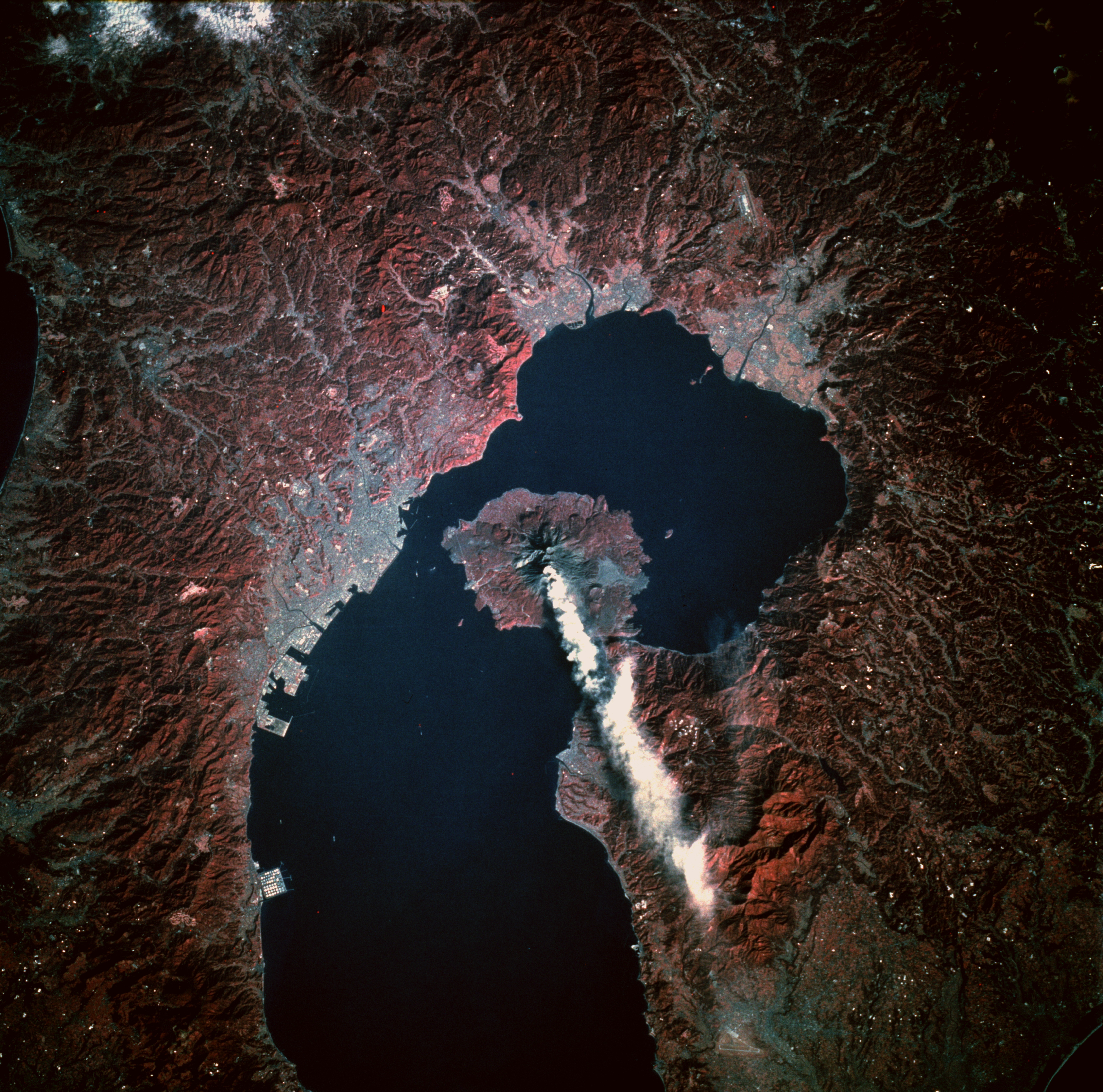
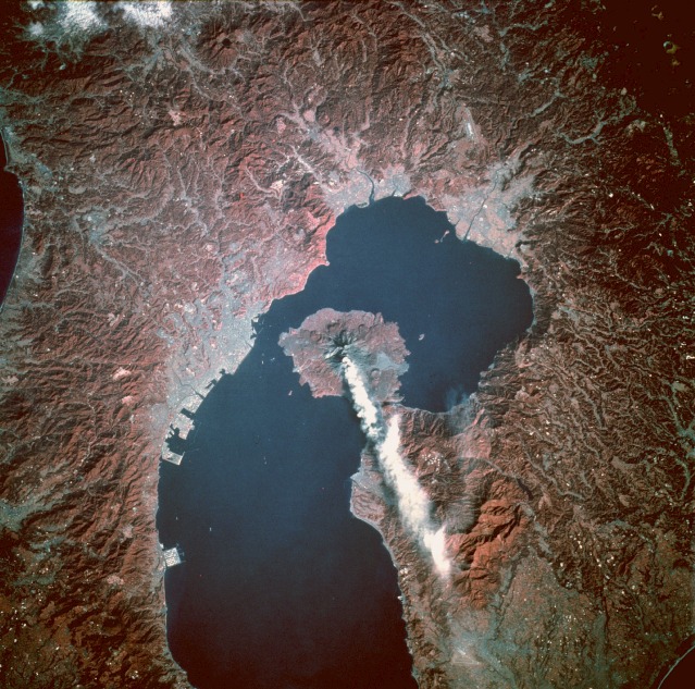
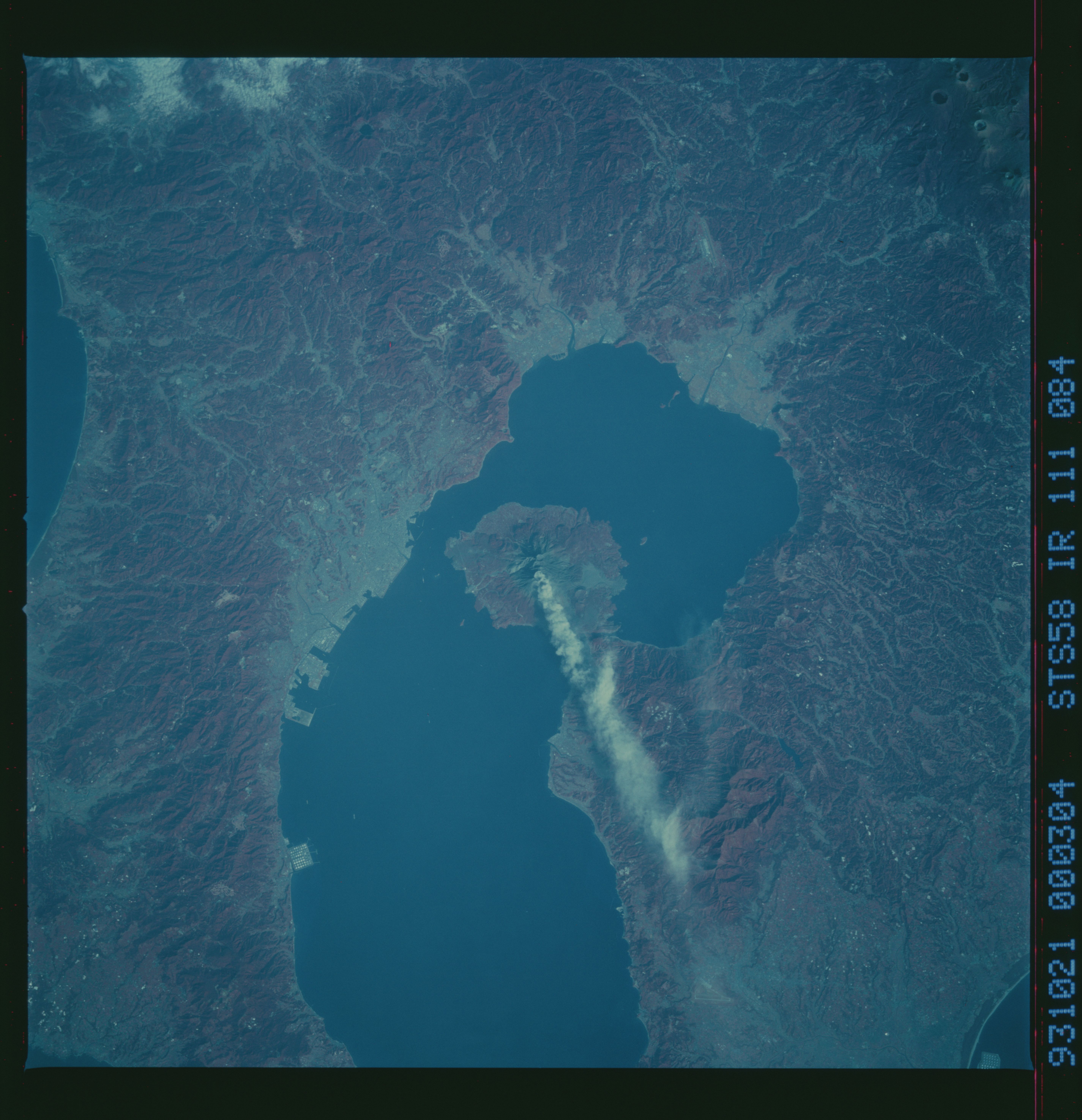
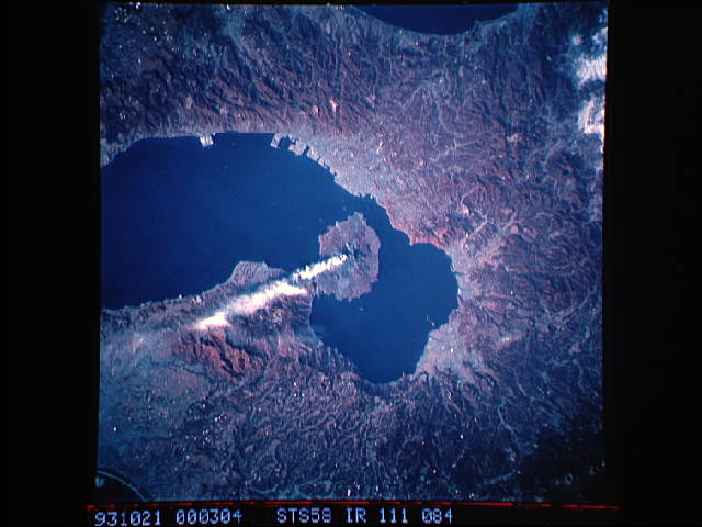
Image Caption: STS058-111-84 Sakura-jima Volcano, Kyushu, Japan October 1993
Sakura-jima, a very active stratovolcano rising 3665 feet (1117 meters) above sea level, is located on a small peninsula near the northern end of Kagoshima Bay along the southern coast of Kyushu Island. This closeup, near-vertical, infrared photograph shows two craters---one with an ash plume along the volcano's southern flank and another farther north. The absence of red coloring, indicating little or no vegetation, confirms that the most recent lava flows occurred on the eastern flank of the volcano. The volcano's Minami-dake crater produces an eruption with a minimal ash plume almost daily. The characteristic radial drainage pattern for most stratovolcanoes is observed for Sakura-jima. The infrared film helps accentuate the blue-gray urban areas and the pink agricultural and forested areas. Visible are the larger port city of Kagoshima west of Sakura-jima Volcano, the two smaller cities of Kajiki and Kokubu, and an airport with one runway along the northern end of Kagoshima Bay.
Sakura-jima, a very active stratovolcano rising 3665 feet (1117 meters) above sea level, is located on a small peninsula near the northern end of Kagoshima Bay along the southern coast of Kyushu Island. This closeup, near-vertical, infrared photograph shows two craters---one with an ash plume along the volcano's southern flank and another farther north. The absence of red coloring, indicating little or no vegetation, confirms that the most recent lava flows occurred on the eastern flank of the volcano. The volcano's Minami-dake crater produces an eruption with a minimal ash plume almost daily. The characteristic radial drainage pattern for most stratovolcanoes is observed for Sakura-jima. The infrared film helps accentuate the blue-gray urban areas and the pink agricultural and forested areas. Visible are the larger port city of Kagoshima west of Sakura-jima Volcano, the two smaller cities of Kajiki and Kokubu, and an airport with one runway along the northern end of Kagoshima Bay.
