STS058-109-39
| NASA Photo ID | STS058-109-39 |
| Focal Length | 250mm |
| Date taken | 1993.10.21 |
| Time taken | 10:43:50 GMT |
Resolutions offered for this image:
4084 x 4084 pixels 639 x 639 pixels 5700 x 5900 pixels 500 x 518 pixels 640 x 480 pixels
4084 x 4084 pixels 639 x 639 pixels 5700 x 5900 pixels 500 x 518 pixels 640 x 480 pixels


Cloud masks available for this image:
Spacecraft nadir point: 38.9° N, 16.9° E
Photo center point: 38.5° N, 16.5° E
Photo center point by machine learning:
Photo center point: 38.5° N, 16.5° E
Photo center point by machine learning:
Nadir to Photo Center: Southwest
Spacecraft Altitude: 151 nautical miles (280km)
Country or Geographic Name: | ITALY |
Features: | POINT STILO |
| Features Found Using Machine Learning: | |
Cloud Cover Percentage: | 5 (1-10)% |
Sun Elevation Angle: | 40° |
Sun Azimuth: | 182° |
Camera: | Hasselblad |
Focal Length: | 250mm |
Camera Tilt: | 13 degrees |
Format: | 2443: Kodak Aerochrome 2443, color IR, thin base, EA-5 process thru June 1999, E-6 process afterward |
Film Exposure: | Normal |
| Additional Information | |
| Width | Height | Annotated | Cropped | Purpose | Links |
|---|---|---|---|---|---|
| 4084 pixels | 4084 pixels | No | No | Earth From Space collection | Download Image |
| 639 pixels | 639 pixels | No | No | Earth From Space collection | Download Image |
| 5700 pixels | 5900 pixels | No | No | Download Image | |
| 500 pixels | 518 pixels | No | No | Download Image | |
| 640 pixels | 480 pixels | No | No | Download Image |
Download Packaged File
Download a Google Earth KML for this Image
View photo footprint information
Download a GeoTIFF for this photo
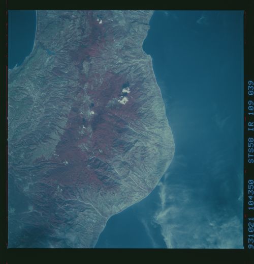
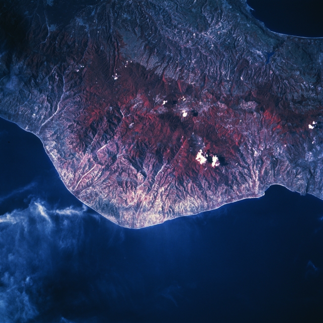
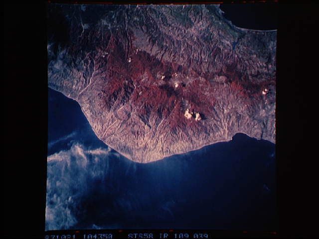
Image Caption: STS058-109-039 Point Stilo, Italy October 1993
The color infrared image (green vegetation is portrayed as shades of red) accentuates the heavily forested mountainous terrain (center of image), known as the Serre, in the Calabria region of southern Italy. Forest species include firs, beeches, and chestnut trees. Mt. Pecorara, highest peak in the Serre Mountains (4668 feet-1422 meters), is located near the center of the picture. Many scenic gorges have been carved out of the mountains by swift-flowing, short rivers that drain to the southeast into the Ionian Sea (bottom). Part of the narrowest point (22 miles-35 km) in Italy, the isthmus of Marcellinara, can be seen along the north (right) edge of the image. A small section of the Tyrrhenian Sea is visible as a dark feature in the top right corner (upper right). Because of the ruggedness of the terrain this region is sparsely populated. Some clouds are visible just south of Point Stilo (lower left quadrant of the image).
The color infrared image (green vegetation is portrayed as shades of red) accentuates the heavily forested mountainous terrain (center of image), known as the Serre, in the Calabria region of southern Italy. Forest species include firs, beeches, and chestnut trees. Mt. Pecorara, highest peak in the Serre Mountains (4668 feet-1422 meters), is located near the center of the picture. Many scenic gorges have been carved out of the mountains by swift-flowing, short rivers that drain to the southeast into the Ionian Sea (bottom). Part of the narrowest point (22 miles-35 km) in Italy, the isthmus of Marcellinara, can be seen along the north (right) edge of the image. A small section of the Tyrrhenian Sea is visible as a dark feature in the top right corner (upper right). Because of the ruggedness of the terrain this region is sparsely populated. Some clouds are visible just south of Point Stilo (lower left quadrant of the image).
