STS056-80-10
| NASA Photo ID | STS056-80-10 |
| Focal Length | 250mm |
| Date taken | 1993.04.10 |
| Time taken | 10:39:06 GMT |
Resolutions offered for this image:
5700 x 6000 pixels 500 x 526 pixels 640 x 480 pixels 398 x 449 pixels
5700 x 6000 pixels 500 x 526 pixels 640 x 480 pixels 398 x 449 pixels


Cloud masks available for this image:
Spacecraft nadir point: 46.5° N, 52.8° W
Photo center point: 47.0° N, 53.0° W
Photo center point by machine learning:
Photo center point: 47.0° N, 53.0° W
Photo center point by machine learning:
Nadir to Photo Center: North
Spacecraft Altitude: 164 nautical miles (304km)
Country or Geographic Name: | CANADA-N |
Features: | AVALON PEN., ICE FLOWS |
| Features Found Using Machine Learning: | |
Cloud Cover Percentage: | 30 (26-50)% |
Sun Elevation Angle: | 17° |
Sun Azimuth: | 96° |
Camera: | Hasselblad |
Focal Length: | 250mm |
Camera Tilt: | 11 degrees |
Format: | 5017: Kodak, natural color positive, Ektachrome, X Professional, ASA 64, standard base |
Film Exposure: | Normal |
| Additional Information | |
| Width | Height | Annotated | Cropped | Purpose | Links |
|---|---|---|---|---|---|
| 5700 pixels | 6000 pixels | No | No | Download Image | |
| 500 pixels | 526 pixels | No | No | Download Image | |
| 640 pixels | 480 pixels | No | No | Download Image | |
| 398 pixels | 449 pixels | No | No | Download Image |
Download Packaged File
Download a Google Earth KML for this Image
View photo footprint information
Download a GeoTIFF for this photo
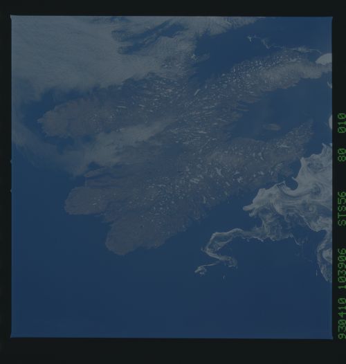
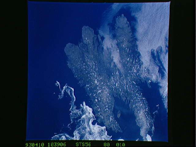
Image Caption: STS056-80-10 The Avalon Peninsula
This is a detailed view of the folded landscape of the Avalon
Peninsula. Thousands of lakes (mostly snow-covered) sit between the
ridges. Numerous fjords finger inward from the coast and create deep
embayments. The Avalon Peninsula frequently marks the southern
boundary of the sea ice of the Labrador Sea. T284B
