STS056-78-91
| NASA Photo ID | STS056-78-91 |
| Focal Length | 250mm |
| Date taken | 1993.04.10 |
| Time taken | 09:12:34 GMT |
Resolutions offered for this image:
4096 x 4096 pixels 640 x 640 pixels 5700 x 6000 pixels 500 x 526 pixels 640 x 480 pixels
4096 x 4096 pixels 640 x 640 pixels 5700 x 6000 pixels 500 x 526 pixels 640 x 480 pixels


Cloud masks available for this image:
Spacecraft nadir point: 35.8° N, 15.6° W
Photo center point: 32.5° N, 17.0° W
Photo center point by machine learning:
Photo center point: 32.5° N, 17.0° W
Photo center point by machine learning:
Nadir to Photo Center: South
Spacecraft Altitude: 162 nautical miles (300km)
Country or Geographic Name: | MADEIRA ISLANDS |
Features: | MADIERA ISLAND |
| Features Found Using Machine Learning: | |
Cloud Cover Percentage: | 30 (26-50)% |
Sun Elevation Angle: | 31° |
Sun Azimuth: | 103° |
Camera: | Hasselblad |
Focal Length: | 250mm |
Camera Tilt: | 53 degrees |
Format: | 5017: Kodak, natural color positive, Ektachrome, X Professional, ASA 64, standard base |
Film Exposure: | Normal |
| Additional Information | |
| Width | Height | Annotated | Cropped | Purpose | Links |
|---|---|---|---|---|---|
| 4096 pixels | 4096 pixels | No | No | Earth From Space collection | Download Image |
| 640 pixels | 640 pixels | No | No | Earth From Space collection | Download Image |
| 5700 pixels | 6000 pixels | No | No | Download Image | |
| 500 pixels | 526 pixels | No | No | Download Image | |
| 640 pixels | 480 pixels | No | No | Download Image |
Download Packaged File
Download a Google Earth KML for this Image
View photo footprint information
Download a GeoTIFF for this photo
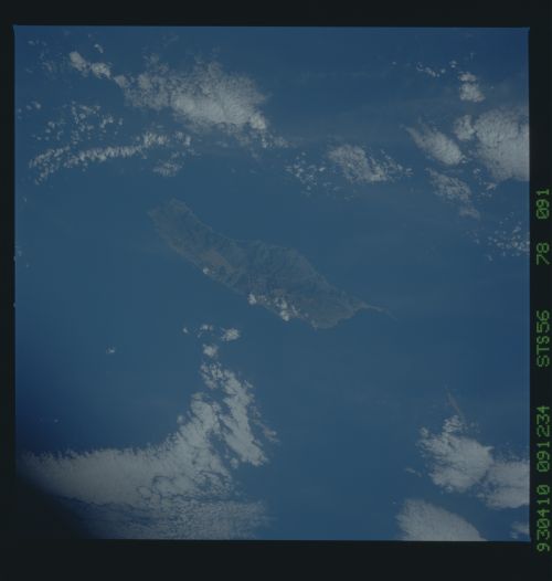
Image Caption: STS056-078-091 Madeira Island, Portugal April 1993
Located in the Atlantic Ocean 350 miles (565 km) off the west coast of Morocco, Madeira Island can be seen in this southeast-looking view. Madeira Island is 34 miles (55 km) long and 12 miles (19 km) wide. The island has deep ravines and rugged mountains, with the highest point being Ruivo Peak near the center of the island at 6106 feet (1862 meters). The north coast of the island is particularly steep and very wild. The island produces wine, sugar, bananas, tropical fruits, and potatoes. Fishing, handicrafts, and tourism are other industries. Funchal, located on the southeast coast, is the main city on the island.
Located in the Atlantic Ocean 350 miles (565 km) off the west coast of Morocco, Madeira Island can be seen in this southeast-looking view. Madeira Island is 34 miles (55 km) long and 12 miles (19 km) wide. The island has deep ravines and rugged mountains, with the highest point being Ruivo Peak near the center of the island at 6106 feet (1862 meters). The north coast of the island is particularly steep and very wild. The island produces wine, sugar, bananas, tropical fruits, and potatoes. Fishing, handicrafts, and tourism are other industries. Funchal, located on the southeast coast, is the main city on the island.
