STS056-152-52

| NASA Photo ID | STS056-152-52 |
| Focal Length | 250mm |
| Date taken | 1993.04.__ |
| Time taken | GMT |

Cloud masks available for this image:
Spacecraft nadir point:
Photo center point: 27.5° N, 84.5° E
Photo center point by machine learning:
Photo center point: 27.5° N, 84.5° E
Photo center point by machine learning:
Nadir to Photo Center:
Spacecraft Altitude: nautical miles (0km)
Country or Geographic Name: | NEPAL |
Features: | JHAWANI AREA, FOOTHILLS |
| Features Found Using Machine Learning: | |
Cloud Cover Percentage: | 0 (no clouds present) |
Sun Elevation Angle: | ° |
Sun Azimuth: | ° |
Camera: | Linhof |
Focal Length: | 250mm |
Camera Tilt: | Low Oblique |
Format: | QX868: Kodak, natural color positive, Ektachrome QX868(5017 emulsion), ASA 64, thin base |
Film Exposure: | Normal |
| Additional Information | |
| Width | Height | Annotated | Cropped | Purpose | Links |
|---|---|---|---|---|---|
| 4472 pixels | 5661 pixels | No | No | Earth From Space collection | Download Image |
| 505 pixels | 640 pixels | No | No | Earth From Space collection | Download Image |
| 640 pixels | 480 pixels | No | No | ISD 1 | Download Image |
Download Packaged File
Download a Google Earth KML for this Image
View photo footprint information
Download a GeoTIFF for this photo
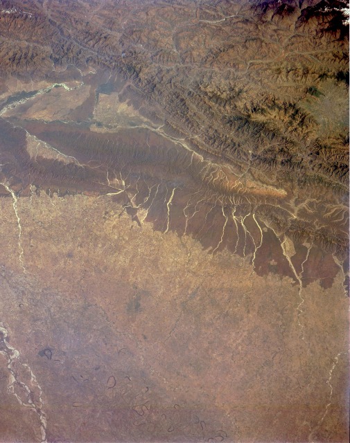
Image Caption: STS056-152-052 Himalayan Foothills and Valleys, Nepal April 1993
The brown area near the center of the photograph is a section of the east-west trending Himalayan foothills [average elevation of 2000 feet (610 meters)] with north-south flowing rivers and deep valleys. South of these foothills, the Tarai, a subtropical, fertile lowland, merges into part of the northern plains of the Ganges River in northern India. A small section of the southeast-flowing, multichanneled Gandak River of northeast India is visible near the southwestern corner of the photograph. Many oxbow lakes and meander scars northeast of the present watercourse denote the former stream channels for this river. A northwest-southeast canal pattern that looks like very narrow black lines traverses the plains. North of the foothills appear mountains with deeply incised river valleys and elevations ranging between 8000 and 9000 feet (2440 and 2740 meters) above sea level. Part of the capital, Kathmandu (estimated population of 385 000), is visible in a valley along the eastern edge of the photograph. Deforestation has removed approximately one-third of Nepal's alpine woodlands since the 1960s. Space Shuttle photography provides a tool to monitor and map land use change and the rate of deforestation.
The brown area near the center of the photograph is a section of the east-west trending Himalayan foothills [average elevation of 2000 feet (610 meters)] with north-south flowing rivers and deep valleys. South of these foothills, the Tarai, a subtropical, fertile lowland, merges into part of the northern plains of the Ganges River in northern India. A small section of the southeast-flowing, multichanneled Gandak River of northeast India is visible near the southwestern corner of the photograph. Many oxbow lakes and meander scars northeast of the present watercourse denote the former stream channels for this river. A northwest-southeast canal pattern that looks like very narrow black lines traverses the plains. North of the foothills appear mountains with deeply incised river valleys and elevations ranging between 8000 and 9000 feet (2440 and 2740 meters) above sea level. Part of the capital, Kathmandu (estimated population of 385 000), is visible in a valley along the eastern edge of the photograph. Deforestation has removed approximately one-third of Nepal's alpine woodlands since the 1960s. Space Shuttle photography provides a tool to monitor and map land use change and the rate of deforestation.
