STS056-101-64

| NASA Photo ID | STS056-101-64 |
| Focal Length | 250mm |
| Date taken | 1993.04.12 |
| Time taken | 00:49:12 GMT |
Resolutions offered for this image:
4796 x 4796 pixels 639 x 639 pixels 5700 x 6000 pixels 500 x 526 pixels 640 x 480 pixels
4796 x 4796 pixels 639 x 639 pixels 5700 x 6000 pixels 500 x 526 pixels 640 x 480 pixels
Cloud masks available for this image:
Spacecraft nadir point: 45.7° S, 170.2° E
Photo center point: 44.0° S, 170.5° E
Photo center point by machine learning:
Photo center point: 44.0° S, 170.5° E
Photo center point by machine learning:
Nadir to Photo Center: North
Spacecraft Altitude: 168 nautical miles (311km)
Country or Geographic Name: | NEW ZEALAND-SI |
Features: | LAKE TEKAPO, LAKE PUKAKI |
| Features Found Using Machine Learning: | |
Cloud Cover Percentage: | 5 (1-10)% |
Sun Elevation Angle: | 36° |
Sun Azimuth: | 357° |
Camera: | Hasselblad |
Focal Length: | 250mm |
Camera Tilt: | 32 degrees |
Format: | 5017: Kodak, natural color positive, Ektachrome, X Professional, ASA 64, standard base |
Film Exposure: | Normal |
| Additional Information | |
| Width | Height | Annotated | Cropped | Purpose | Links |
|---|---|---|---|---|---|
| 4796 pixels | 4796 pixels | No | No | Earth From Space collection | Download Image |
| 639 pixels | 639 pixels | No | No | Earth From Space collection | Download Image |
| 5700 pixels | 6000 pixels | No | No | Download Image | |
| 500 pixels | 526 pixels | No | No | Download Image | |
| 640 pixels | 480 pixels | No | No | Download Image |
Download Packaged File
Download a Google Earth KML for this Image
View photo footprint information
Download a GeoTIFF for this photo
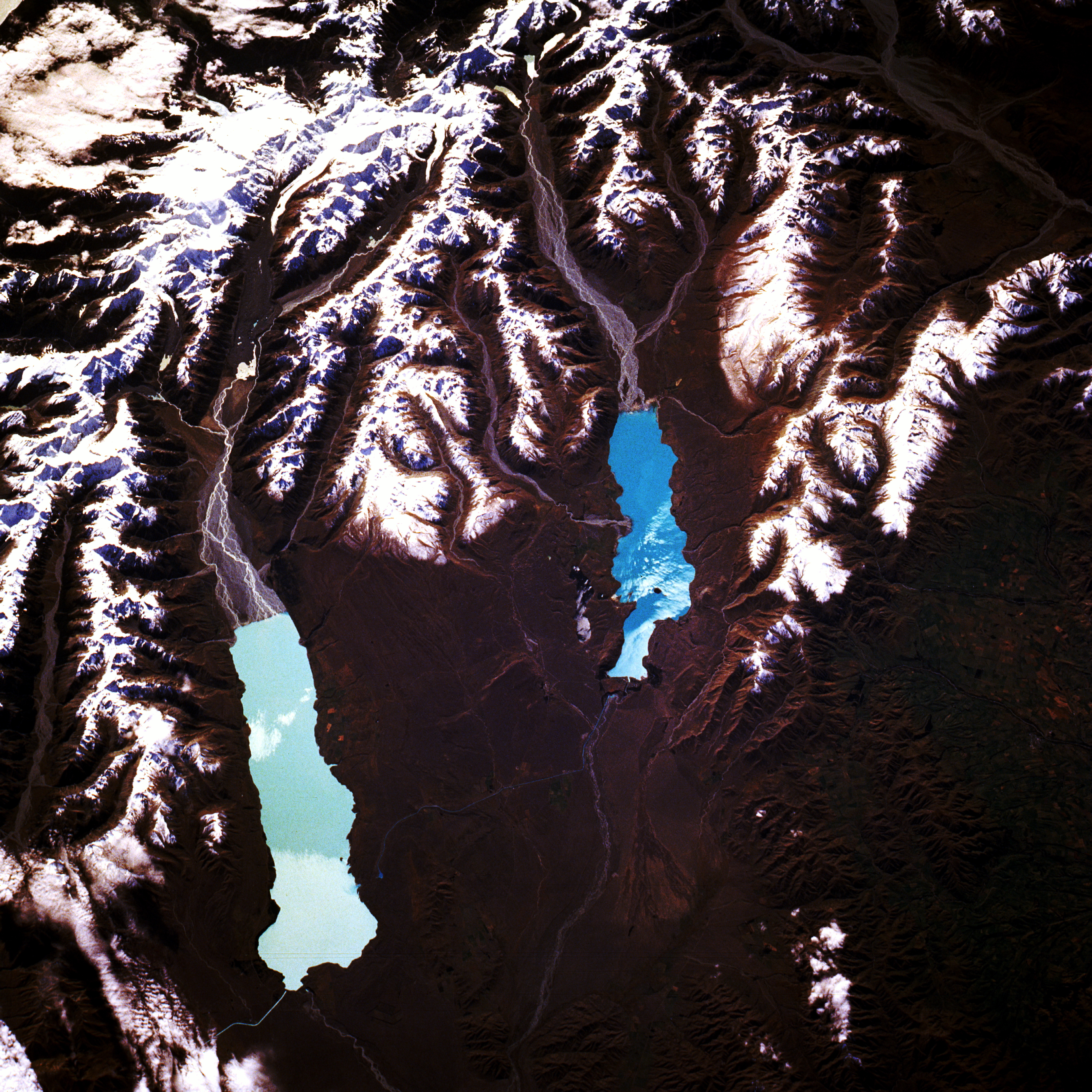
Image Caption: STS056-101-064 Lake Pukaki and Lake Tekapo, South Island, New Zealand April 1993
This spectacular, north-northeast-looking, low-oblique photograph shows the high country of the Southern Alps and two glacier-fed lakes, Pukaki and Tekapo. Visible near the northwest corner of the photograph is Mount Cook, the highest peak in the Southern Alps at 12 349 feet (3766 meters). East of Mount Cook is the largest glacier in New Zealand, the Tasman Glacier, 18 miles (29 kilometers) long and more than 1 mile (2 kilometers) wide. The Southern Alps, paralleling the west coast of South Island, are extensively glaciated with many deep gorges. Of the 3155 active glaciers in the Southern Alps, most are within 100 miles (160 kilometers) of Mount Cook. From Tasman Glacier, the braided Tasman River can be seen flowing southward into beautiful Lake Pukaki. The lake is more than 9 miles (15 kilometers) long and covers 32 square miles (83 square kilometers). Its brilliant turquoise color results from finely ground "rock flour" being suspended in the water. East of the Tasman River, the braided Godley River flows into Lake Tekapo, a beautiful lake occupying a vast hollow in downs and terraces of golden tussock grass. Though a hydroelectric control structure now contains the waters of the lake at its southern end, Lake Tekapo owes its origin to the natural dam of an old moraine. East of Lake Tekapo, the agricultural lands of the fertile Canterbury Plain spread toward the coast.
This spectacular, north-northeast-looking, low-oblique photograph shows the high country of the Southern Alps and two glacier-fed lakes, Pukaki and Tekapo. Visible near the northwest corner of the photograph is Mount Cook, the highest peak in the Southern Alps at 12 349 feet (3766 meters). East of Mount Cook is the largest glacier in New Zealand, the Tasman Glacier, 18 miles (29 kilometers) long and more than 1 mile (2 kilometers) wide. The Southern Alps, paralleling the west coast of South Island, are extensively glaciated with many deep gorges. Of the 3155 active glaciers in the Southern Alps, most are within 100 miles (160 kilometers) of Mount Cook. From Tasman Glacier, the braided Tasman River can be seen flowing southward into beautiful Lake Pukaki. The lake is more than 9 miles (15 kilometers) long and covers 32 square miles (83 square kilometers). Its brilliant turquoise color results from finely ground "rock flour" being suspended in the water. East of the Tasman River, the braided Godley River flows into Lake Tekapo, a beautiful lake occupying a vast hollow in downs and terraces of golden tussock grass. Though a hydroelectric control structure now contains the waters of the lake at its southern end, Lake Tekapo owes its origin to the natural dam of an old moraine. East of Lake Tekapo, the agricultural lands of the fertile Canterbury Plain spread toward the coast.
