STS055-92-84

| NASA Photo ID | STS055-92-84 |
| Focal Length | 250mm |
| Date taken | 1993.04.27 |
| Time taken | 05:59:01 GMT |
Resolutions offered for this image:
4096 x 4096 pixels 640 x 640 pixels 5700 x 6000 pixels 500 x 526 pixels 640 x 480 pixels 633 x 639 pixels
4096 x 4096 pixels 640 x 640 pixels 5700 x 6000 pixels 500 x 526 pixels 640 x 480 pixels 633 x 639 pixels


Cloud masks available for this image:
Spacecraft nadir point: 28.5° N, 50.8° E
Photo center point: 29.5° N, 50.5° E
Photo center point by machine learning:
Photo center point: 29.5° N, 50.5° E
Photo center point by machine learning:
Nadir to Photo Center: North
Spacecraft Altitude: 163 nautical miles (302km)
Country or Geographic Name: | IRAN |
Features: | KHARG ISLAND, TANKERS |
| Features Found Using Machine Learning: | |
Cloud Cover Percentage: | 5 (1-10)% |
Sun Elevation Angle: | 51° |
Sun Azimuth: | 104° |
Camera: | Hasselblad |
Focal Length: | 250mm |
Camera Tilt: | 21 degrees |
Format: | VELVI: Fuji, natural color positive, Velvia 50, CS 135-36, ASA 32, standard base |
Film Exposure: | Normal |
| Additional Information | |
| Width | Height | Annotated | Cropped | Purpose | Links |
|---|---|---|---|---|---|
| 4096 pixels | 4096 pixels | No | No | Earth From Space collection | Download Image |
| 640 pixels | 640 pixels | No | No | Earth From Space collection | Download Image |
| 5700 pixels | 6000 pixels | No | No | Download Image | |
| 500 pixels | 526 pixels | No | No | Download Image | |
| 640 pixels | 480 pixels | No | No | Download Image | |
| 633 pixels | 639 pixels | No | No | Download Image |
Download Packaged File
Download a Google Earth KML for this Image
View photo footprint information
Download a GeoTIFF for this photo
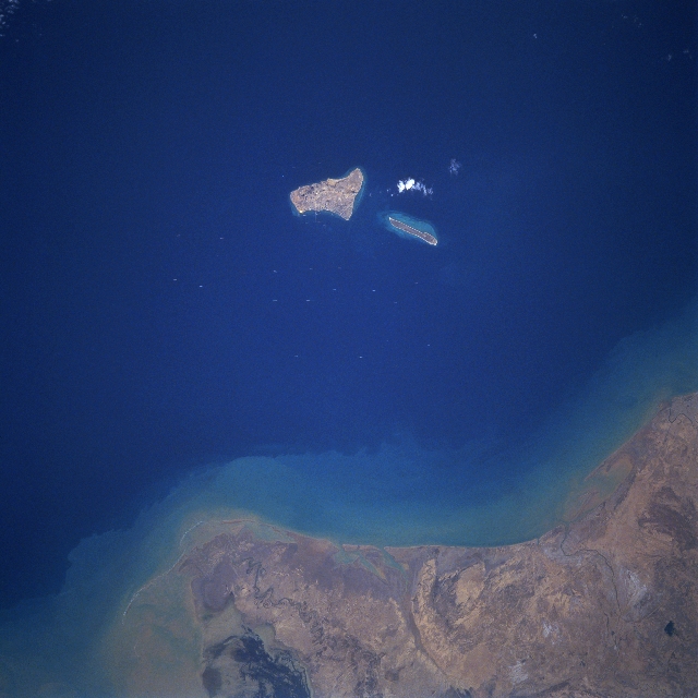
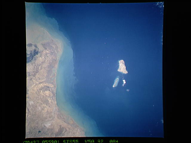
Image Caption: STS055-092-084 Kharg Island, Iran April 1993
Kharg Island, as seen in this near-nadir view, is located in the northeastern Persian Gulf, 16 miles (25 km) off the coast of Iran and 300 miles (483 km) north of the Strait of Hormuz. Once the world's largest offshore crude oil terminal and the principal sea terminal for Iranian oil, the Kharg Island facilities were put out of commission in the fall of 1986. Heavy bombing of the Kharg Island facilities from 1982 through 1986 by the air forces of the government of Iraq during the Iran-Iraq War all but destroyed most of the terminal facilities. Kharg Island was situated in the middle of the Darius Oilfield, also destroyed by the intensive bombing. Repair to all facilities has been very slow, even after the war ended in 1988, due to continued hostile intentions by the Iraqi Government and the Gulf War or 1990-1991.
Kharg Island, as seen in this near-nadir view, is located in the northeastern Persian Gulf, 16 miles (25 km) off the coast of Iran and 300 miles (483 km) north of the Strait of Hormuz. Once the world's largest offshore crude oil terminal and the principal sea terminal for Iranian oil, the Kharg Island facilities were put out of commission in the fall of 1986. Heavy bombing of the Kharg Island facilities from 1982 through 1986 by the air forces of the government of Iraq during the Iran-Iraq War all but destroyed most of the terminal facilities. Kharg Island was situated in the middle of the Darius Oilfield, also destroyed by the intensive bombing. Repair to all facilities has been very slow, even after the war ended in 1988, due to continued hostile intentions by the Iraqi Government and the Gulf War or 1990-1991.
