STS053-96-83
| NASA Photo ID | STS053-96-83 |
| Focal Length | 250mm |
| Date taken | 1992.12.05 |
| Time taken | 22:19:18 GMT |
Resolutions offered for this image:
3942 x 3963 pixels 636 x 640 pixels 5700 x 6000 pixels 500 x 526 pixels 640 x 480 pixels 960 x 945 pixels
3942 x 3963 pixels 636 x 640 pixels 5700 x 6000 pixels 500 x 526 pixels 640 x 480 pixels 960 x 945 pixels


Cloud masks available for this image:
Spacecraft nadir point: 50.9° N, 160.5° E
Photo center point: 52.0° N, 157.5° E
Photo center point by machine learning:
Photo center point: 52.0° N, 157.5° E
Photo center point by machine learning:
Nadir to Photo Center: West
Spacecraft Altitude: 182 nautical miles (337km)
Country or Geographic Name: | RUSSIAN FEDERATION |
Features: | KAMCHATKA PEN., SNOW |
| Features Found Using Machine Learning: | |
Cloud Cover Percentage: | 30 (26-50)% |
Sun Elevation Angle: | 8° |
Sun Azimuth: | 141° |
Camera: | Hasselblad |
Focal Length: | 250mm |
Camera Tilt: | 47 degrees |
Format: | 5017: Kodak, natural color positive, Ektachrome, X Professional, ASA 64, standard base |
Film Exposure: | Normal |
| Additional Information | |
| Width | Height | Annotated | Cropped | Purpose | Links |
|---|---|---|---|---|---|
| 3942 pixels | 3963 pixels | No | No | Earth From Space collection | Download Image |
| 636 pixels | 640 pixels | No | No | Earth From Space collection | Download Image |
| 5700 pixels | 6000 pixels | No | No | Download Image | |
| 500 pixels | 526 pixels | No | No | Download Image | |
| 640 pixels | 480 pixels | No | No | Download Image | |
| 960 pixels | 945 pixels | Yes | No | Download Image |
Download Packaged File
Download a Google Earth KML for this Image
View photo footprint information
Download a GeoTIFF for this photo
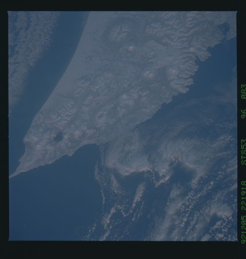
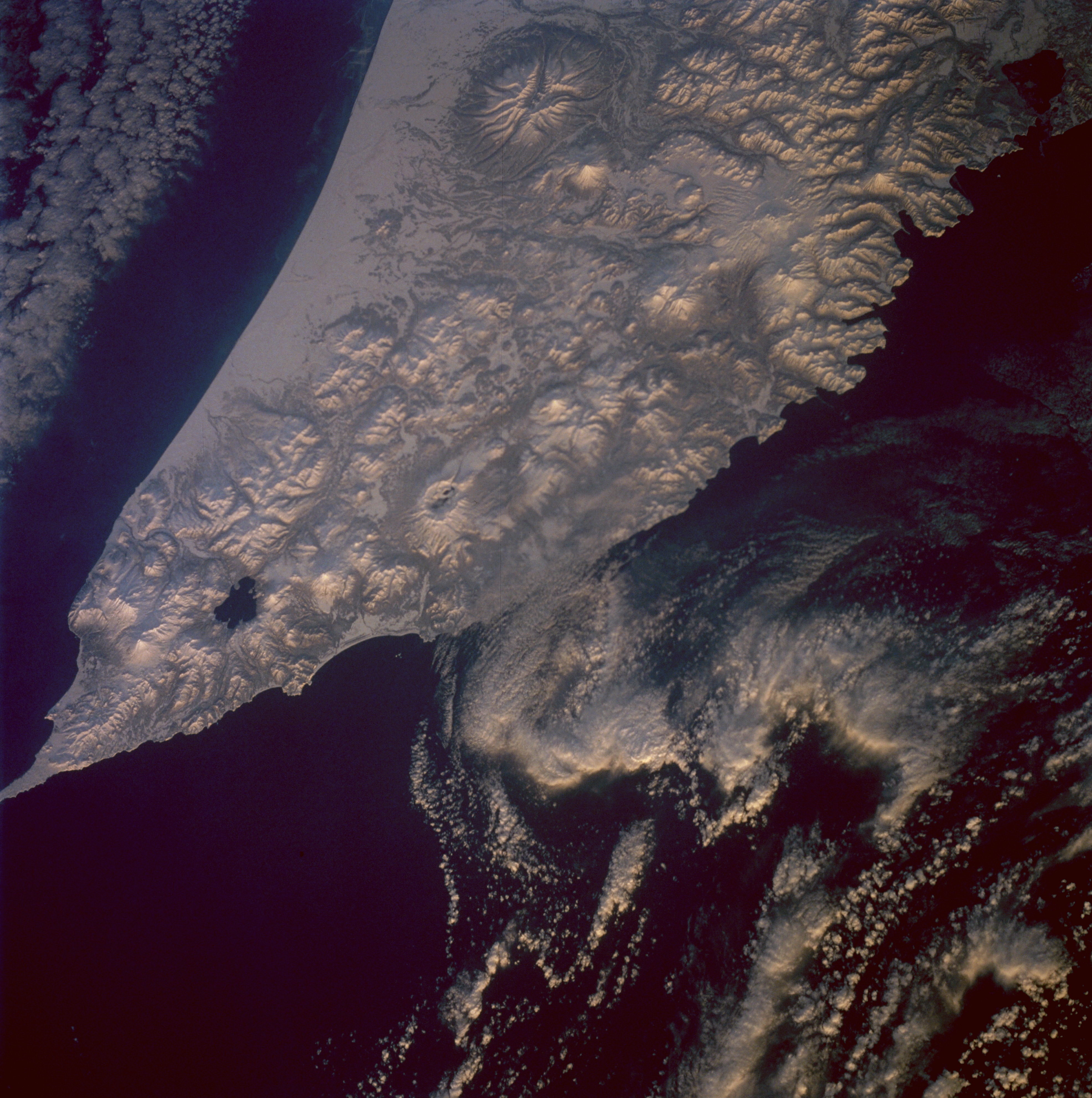
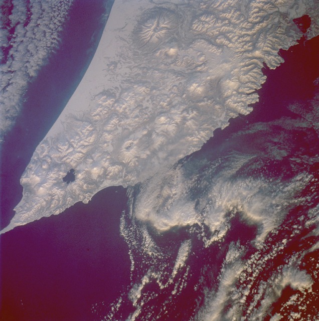
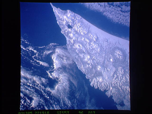
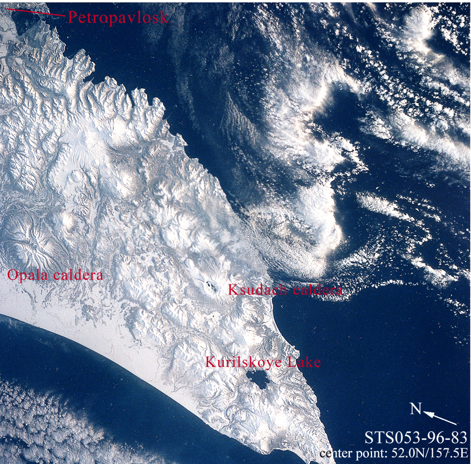
Image Caption: STS053-96-83 Volcanoes, Kamchatka Peninsula, Russia December 1992
No volcanoes appear to be active at the time this photograph was taken of the southern tip of snow-covered Kamchatka Peninsula. The snow-covered terrain actually increases the clarity of the volcanic landscape for the viewer. Except for the plains along the west coast of Kamchatka, a variety of volcanic landforms (stratovolcanoes, shield volcanoes, complex volcanoes, cinder cones, and calderas) covers almost the entire Kamchatka Peninsula. Three prominent volcanic features appear in the photograph--the massive but severely eroded volcano along the northwest side of the photograph, approximately 30 miles (50 kilometers) in diameter at its base; the lake near the southern end of Kamchatka (Kurile Lake), which is actually a water-filled caldera from an older volcano (Pauzhetka Volcano); and a large caldera (Ksudach Volcano) northeast of Lake Kurile that reveals just a small area of open water. The peaks of several of the taller stratovolcanoes in this photograph exceed 6000 feet (1800 meters) above sea level. The Kamchatka Peninsula is bounded by the Bering Sea on the east and the Sea of Okhotsk on the west.
No volcanoes appear to be active at the time this photograph was taken of the southern tip of snow-covered Kamchatka Peninsula. The snow-covered terrain actually increases the clarity of the volcanic landscape for the viewer. Except for the plains along the west coast of Kamchatka, a variety of volcanic landforms (stratovolcanoes, shield volcanoes, complex volcanoes, cinder cones, and calderas) covers almost the entire Kamchatka Peninsula. Three prominent volcanic features appear in the photograph--the massive but severely eroded volcano along the northwest side of the photograph, approximately 30 miles (50 kilometers) in diameter at its base; the lake near the southern end of Kamchatka (Kurile Lake), which is actually a water-filled caldera from an older volcano (Pauzhetka Volcano); and a large caldera (Ksudach Volcano) northeast of Lake Kurile that reveals just a small area of open water. The peaks of several of the taller stratovolcanoes in this photograph exceed 6000 feet (1800 meters) above sea level. The Kamchatka Peninsula is bounded by the Bering Sea on the east and the Sea of Okhotsk on the west.
