STS052-77-2
| NASA Photo ID | STS052-77-2 |
| Focal Length | 250mm |
| Date taken | 1992.10.29 |
| Time taken | 22:17:13 GMT |


Cloud masks available for this image:
Spacecraft nadir point: 15.1° N, 156.0° W
Photo center point: 19.5° N, 155.5° W
Photo center point by machine learning:
Photo center point: 19.5° N, 155.5° W
Photo center point by machine learning:
Nadir to Photo Center: North
Spacecraft Altitude: 157 nautical miles (291km)
Country or Geographic Name: | USA-HAWAII |
Features: | HAWAII |
| Features Found Using Machine Learning: | |
Cloud Cover Percentage: | 10 (1-10)% |
Sun Elevation Angle: | 61° |
Sun Azimuth: | 185° |
Camera: | Hasselblad |
Focal Length: | 250mm |
Camera Tilt: | Low Oblique |
Format: | 5017: Kodak, natural color positive, Ektachrome, X Professional, ASA 64, standard base |
Film Exposure: | Normal |
| Additional Information | |
| Width | Height | Annotated | Cropped | Purpose | Links |
|---|---|---|---|---|---|
| 5700 pixels | 6000 pixels | No | No | Download Image | |
| 500 pixels | 526 pixels | No | No | Download Image | |
| 640 pixels | 480 pixels | No | No | Download Image |
Download Packaged File
Download a Google Earth KML for this Image
View photo footprint information
Download a GeoTIFF for this photo
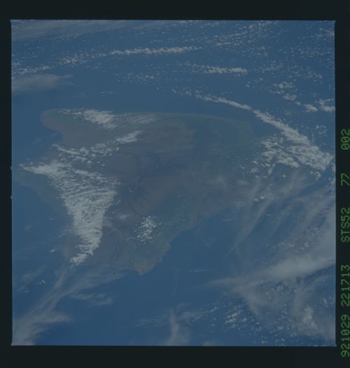
Image Caption: The three main volcanoes which make up the island of Hawaii (19.5N, 155.5W) include the older large shield volcanoes Mauna Loa, Mauna Kea and the more recent Kilauea. The rift zones of Mauna Loa and Mauna Kea are delineated by the black lava flows whereas the smaler Kilauea can be seen venting steam. This color image is one of a pair (see STS052-95-037) to compare the differences between color film and color infrared film.
