STS052-74-58
| NASA Photo ID | STS052-74-58 |
| Focal Length | 50mm |
| Date taken | 1992.10.23 |
| Time taken | 11:26:05 GMT |
Resolutions offered for this image:
5300 x 5194 pixels 640 x 627 pixels 5700 x 6000 pixels 500 x 526 pixels 640 x 480 pixels
5300 x 5194 pixels 640 x 627 pixels 5700 x 6000 pixels 500 x 526 pixels 640 x 480 pixels


Cloud masks available for this image:
Spacecraft nadir point: 25.2° N, 31.4° E
Photo center point: 30.0° N, 32.5° E
Photo center point by machine learning:
Photo center point: 30.0° N, 32.5° E
Photo center point by machine learning:
Nadir to Photo Center: North
Spacecraft Altitude: 163 nautical miles (302km)
Country or Geographic Name: | EGYPT |
Features: | SUEZ CANAL AREA |
| Features Found Using Machine Learning: | |
Cloud Cover Percentage: | 0 (no clouds present) |
Sun Elevation Angle: | 45° |
Sun Azimuth: | 219° |
Camera: | Hasselblad |
Focal Length: | 50mm |
Camera Tilt: | Low Oblique |
Format: | 5017: Kodak, natural color positive, Ektachrome, X Professional, ASA 64, standard base |
Film Exposure: | Normal |
| Additional Information | |
| Width | Height | Annotated | Cropped | Purpose | Links |
|---|---|---|---|---|---|
| 5300 pixels | 5194 pixels | No | No | Earth From Space collection | Download Image |
| 640 pixels | 627 pixels | No | No | Earth From Space collection | Download Image |
| 5700 pixels | 6000 pixels | No | No | Download Image | |
| 500 pixels | 526 pixels | No | No | Download Image | |
| 640 pixels | 480 pixels | No | No | Download Image |
Download Packaged File
Download a Google Earth KML for this Image
View photo footprint information
Download a GeoTIFF for this photo
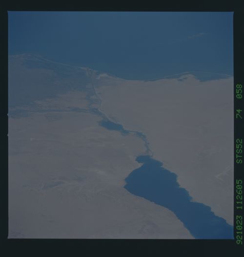
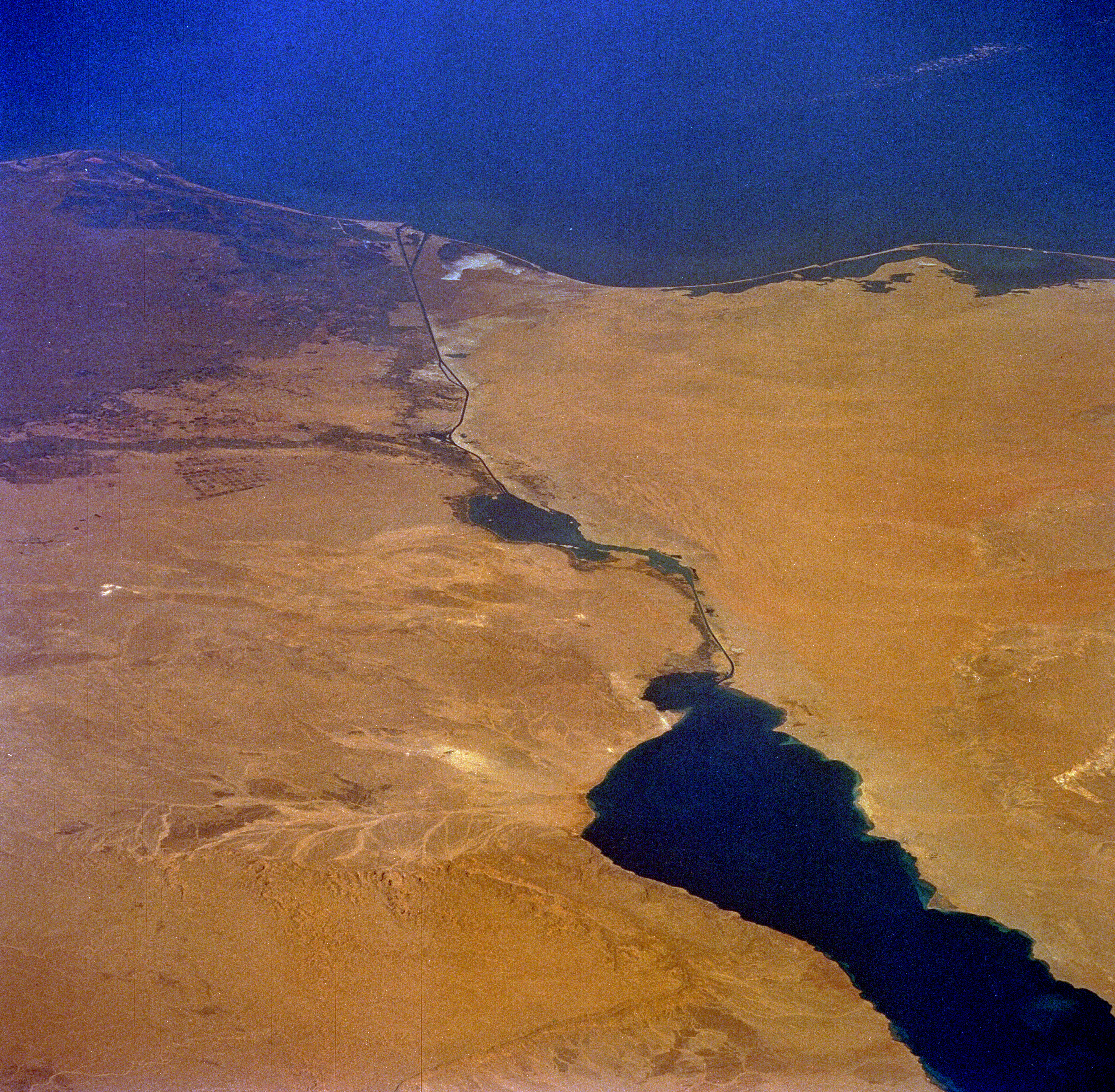
Image Caption: STS052-074-058 Suez Canal, Egypt October 1992
The entire length of Egypt's Suez Canal (dark north-south line) is visible in this low-oblique, northeast-looking photograph. Extending from the port city of Suez in the south to Port Said in the north, a distance of approximately 100 miles (160 kilometers), the canal connects the Red Sea with the eastern Mediterranean Sea. The minimum width of the canal is 179 feet (55 meters), and the minimum depth of the channel is 40 feet (12 meters). Ships entering the canal from the south pass through the Gulf of Suez, Little Bitter Lake, Great Bitter Lake, and into the main body of the canal. The sandy desert of the northwest Sinai Peninsula occupies the territory east of the canal, and the large dark area west of the canal is the eastern extent of the Nile River Delta. The dendrite drainage feature along the northwest side of the Gulf of Suez is Khafuri Wadi. The narrow swath of green extending east-west on the west side of the canal is a strip of irrigated farmland that borders the Ismailia Canal, which connects Cairo with the Suez Canal at the city of Ismailia. Many center-pivot irrigation field patterns are visible in a roughly rectangular area south of the Ismailia Canal.
The entire length of Egypt's Suez Canal (dark north-south line) is visible in this low-oblique, northeast-looking photograph. Extending from the port city of Suez in the south to Port Said in the north, a distance of approximately 100 miles (160 kilometers), the canal connects the Red Sea with the eastern Mediterranean Sea. The minimum width of the canal is 179 feet (55 meters), and the minimum depth of the channel is 40 feet (12 meters). Ships entering the canal from the south pass through the Gulf of Suez, Little Bitter Lake, Great Bitter Lake, and into the main body of the canal. The sandy desert of the northwest Sinai Peninsula occupies the territory east of the canal, and the large dark area west of the canal is the eastern extent of the Nile River Delta. The dendrite drainage feature along the northwest side of the Gulf of Suez is Khafuri Wadi. The narrow swath of green extending east-west on the west side of the canal is a strip of irrigated farmland that borders the Ismailia Canal, which connects Cairo with the Suez Canal at the city of Ismailia. Many center-pivot irrigation field patterns are visible in a roughly rectangular area south of the Ismailia Canal.
