STS052-153-212
| NASA Photo ID | STS052-153-212 |
| Focal Length | 90mm |
| Date taken | 1992.10.28 |
| Time taken | 10:15:55 GMT |
Resolutions offered for this image:
640 x 480 pixels
640 x 480 pixels
Cloud masks available for this image:
Spacecraft nadir point: 12.4° N, 42.8° E
Photo center point: 11.5° N, 42.5° E
Photo center point by machine learning:
Photo center point: 11.5° N, 42.5° E
Photo center point by machine learning:
Nadir to Photo Center: South
Spacecraft Altitude: 157 nautical miles (291km)
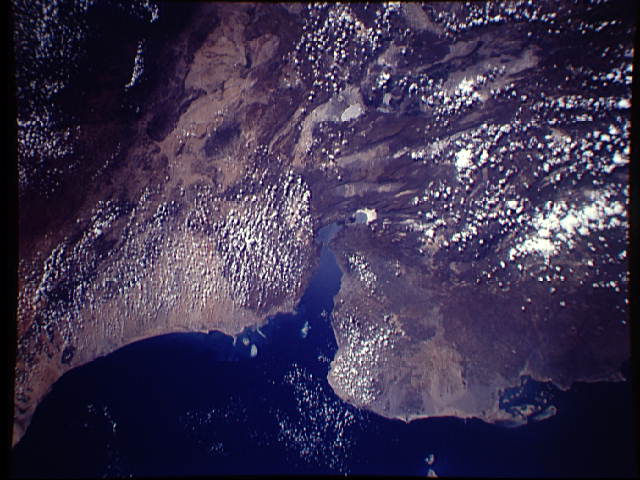
Country or Geographic Name: | DJIBOUTI |
Features: | GULF OF TADJOURA, COAST |
| Features Found Using Machine Learning: | |
Cloud Cover Percentage: | 25 (11-25)% |
Sun Elevation Angle: | 57° |
Sun Azimuth: | 219° |
Camera: | Linhof |
Focal Length: | 90mm |
Camera Tilt: | 20 degrees |
Format: | QX868: Kodak, natural color positive, Ektachrome QX868(5017 emulsion), ASA 64, thin base |
Film Exposure: | Normal |
| Additional Information | |
| Width | Height | Annotated | Cropped | Purpose | Links |
|---|---|---|---|---|---|
| 640 pixels | 480 pixels | No | No | ISD 1 | Download Image |
Download Packaged File
Download a Google Earth KML for this Image
View photo footprint information
Download a GeoTIFF for this photo
Image Caption: The Afar Triangle of Ethiopia (11.5N, 42.5E) is a very active plate tectonic region. The region is stressed by Saudi Arabia moving away from Africa and East Africa tearing itself away from the rest of Africa. Because of the plate movements in three different directions, The Afar Triangle is stretched thin and torn resulting in a series of faults seen as long parallel valleys. There is frequent volcanic activity and lava flows occur along the faults.
