STS052-153-102
| NASA Photo ID | STS052-153-102 |
| Focal Length | 90mm |
| Date taken | 1992.10.26 |
| Time taken | 17:35:21 GMT |

Cloud masks available for this image:
Spacecraft nadir point: 23.2° N, 80.5° W
Photo center point: 24.0° N, 77.0° W
Photo center point by machine learning:
Photo center point: 24.0° N, 77.0° W
Photo center point by machine learning:
Nadir to Photo Center: East
Spacecraft Altitude: 158 nautical miles (293km)
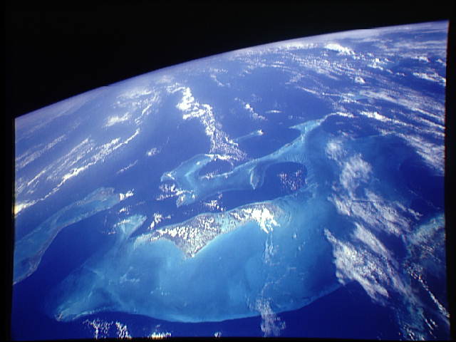
Country or Geographic Name: | BAHAMAS |
Features: | CENTERED ON ANDROS I. |
| Features Found Using Machine Learning: | |
Cloud Cover Percentage: | 70 (51-75)% |
Sun Elevation Angle: | 53° |
Sun Azimuth: | 192° |
Camera: | Linhof |
Focal Length: | 90mm |
Camera Tilt: | High Oblique |
Format: | QX868: Kodak, natural color positive, Ektachrome QX868(5017 emulsion), ASA 64, thin base |
Film Exposure: | Normal |
| Additional Information | |
| Width | Height | Annotated | Cropped | Purpose | Links |
|---|---|---|---|---|---|
| 8000 pixels | 6356 pixels | No | No | Publisher Request | Download Image |
| 640 pixels | 480 pixels | No | No | ISD 1 | Download Image |
Download Packaged File
Download a Google Earth KML for this Image
View photo footprint information
Download a GeoTIFF for this photo
Image Caption: The light blue shallow water platforms of the Bahamas, (24.0N, 77.0W) which are separated by very deep dark blue channels make for a striking scene. In the foreground is Andros Island and in the background are the Tongue of the Ocean, the Exuma Islands, Exuma Sound and the Atlantic Ocean. The Bahamas are one of the few regions where calcium carbonate precipitates directly out of the water, as the mineral aragonite, to form the coral reef islands.
