STS052-153-101
| NASA Photo ID | STS052-153-101 |
| Focal Length | 90mm |
| Date taken | 1992.10.26 |
| Time taken | 17:35:12 GMT |
Resolutions offered for this image:
640 x 480 pixels
640 x 480 pixels
Cloud masks available for this image:
Spacecraft nadir point: 23.4° N, 81.1° W
Photo center point: 27.0° N, 81.0° W
Photo center point by machine learning:
Photo center point: 27.0° N, 81.0° W
Photo center point by machine learning:
Nadir to Photo Center: North
Spacecraft Altitude: 158 nautical miles (293km)
Country or Geographic Name: | USA-FLORIDA |
Features: | FL. PENINSULA, VIEW N |
| Features Found Using Machine Learning: | |
Cloud Cover Percentage: | 40 (26-50)% |
Sun Elevation Angle: | 53° |
Sun Azimuth: | 191° |
Camera: | Linhof |
Focal Length: | 90mm |
Camera Tilt: | 54 degrees |
Format: | QX868: Kodak, natural color positive, Ektachrome QX868(5017 emulsion), ASA 64, thin base |
Film Exposure: | Normal |
| Additional Information | |
| Width | Height | Annotated | Cropped | Purpose | Links |
|---|---|---|---|---|---|
| 640 pixels | 480 pixels | No | No | ISD 1 | Download Image |
Download Packaged File
Download a Google Earth KML for this Image
View photo footprint information
Download a GeoTIFF for this photo
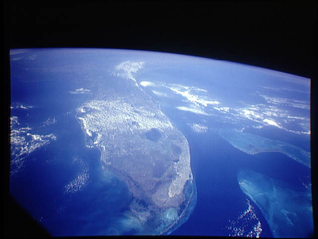
Image Caption: This oblique view documents conditions in South Florida (27.0N, 81.0W) in the aftermath of Hurricane Andrew that severly mauled south Florida on 24 Aug 92, battering Dade County with a 16.9 ft. storm surge and wind gusts of up to 169 mph. An additional feature is the band of haze running across the central portion of the state The band of air pollution has been drawn from the north by a weak cold front and was focused along the east/west axis of the front.
