STS052-151-12
| NASA Photo ID | STS052-151-12 |
| Focal Length | 250mm |
| Date taken | 1992.10.23 |
| Time taken | 18:48:49 GMT |
Resolutions offered for this image:
640 x 480 pixels
640 x 480 pixels
Cloud masks available for this image:
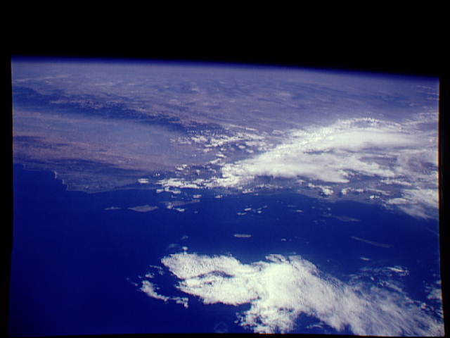
Spacecraft nadir point: 28.2° N, 122.1° W
Photo center point: 35.0° N, 119.0° W
Photo center point by machine learning:
Photo center point: 35.0° N, 119.0° W
Photo center point by machine learning:
Nadir to Photo Center: North
Spacecraft Altitude: 157 nautical miles (291km)
Country or Geographic Name: | USA-CALIFORNIA |
Features: | PAN, SAN JOAQUIN V, COAST |
| Features Found Using Machine Learning: | |
Cloud Cover Percentage: | 40 (26-50)% |
Sun Elevation Angle: | 47° |
Sun Azimuth: | 156° |
Camera: | Linhof |
Focal Length: | 250mm |
Camera Tilt: | High Oblique |
Format: | QX868: Kodak, natural color positive, Ektachrome QX868(5017 emulsion), ASA 64, thin base |
Film Exposure: | Normal |
| Additional Information | |
| Width | Height | Annotated | Cropped | Purpose | Links |
|---|---|---|---|---|---|
| 640 pixels | 480 pixels | No | No | ISD 1 | Download Image |
Download Packaged File
Download a Google Earth KML for this Image
View photo footprint information
Download a GeoTIFF for this photo
Image Caption: This distant and very oblique image of the south Central California Coastline and Channel Islands (35.0N, 119.0W) offers a spectacular and scenic view of the southern west coast, the central San Joaquin Valley, the entire Sierra Nevada Range and across the southwest to the Rocky Mountains on the horizon.
