STS051-102-88
| NASA Photo ID | STS051-102-88 |
| Focal Length | 250mm |
| Date taken | 1993.09.15 |
| Time taken | 18:12:08 GMT |


Cloud masks available for this image:
Spacecraft nadir point: 19.5° N, 153.3° W
Photo center point: 19.5° N, 155.0° W
Photo center point by machine learning:
Photo center point: 19.5° N, 155.0° W
Photo center point by machine learning:
Nadir to Photo Center: West
Spacecraft Altitude: 161 nautical miles (298km)
Country or Geographic Name: | USA-HAWAII |
Features: | HAWAII I., LAVA PLUMES |
| Features Found Using Machine Learning: | |
Cloud Cover Percentage: | 20 (11-25)% |
Sun Elevation Angle: | 30° |
Sun Azimuth: | 98° |
Camera: | Hasselblad |
Focal Length: | 250mm |
Camera Tilt: | 32 degrees |
Format: | VELVI: Fuji, natural color positive, Velvia 50, CS 135-36, ASA 32, standard base |
Film Exposure: | Normal |
| Additional Information | |
| Width | Height | Annotated | Cropped | Purpose | Links |
|---|---|---|---|---|---|
| 5700 pixels | 5900 pixels | No | No | Download Image | |
| 500 pixels | 518 pixels | No | No | Download Image | |
| 640 pixels | 480 pixels | No | No | Download Image |
Download Packaged File
Download a Google Earth KML for this Image
View photo footprint information
Download a GeoTIFF for this photo
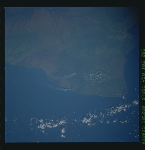
Image Caption: STS051-102-88 Kilauea Volcano, Hawaii During an early morning pass
over the Hawaiian Islands, the STS-51 crew had a rare crystal-clear
view of the erupting Kilauea Volcano. Kilauea, on the southeast side
of the island of Hawaii, has been erupting almost continuously since
January 1983. Kilauea's summit caldera, with the smaller Halemaumau
Crater nestled within it (just above the center of this
southwest-looking picture) is highlighted by the early morning
sunlight. A string of craters extends eastward along the East Rift
Zone, site of the current eruption. Steam blows south from the main
crater lake, Pu'u O'o, now filled with basaltic lava. The hot lava
travels downhill to the ocean through lava tubes and enters the ocean
along the eastern side of the newly built (less than a year old)
Kamoamoa Delta. Where the hot lava (roughly 1150 degrees C) meets the
cool ocean water (22 degrees C), an acid-rich steam plume forms and is
carried to the south and west. The lava flows that covered roads and
subdivisions between 1983 and 1990 can be seen as dark flows to the
east (toward the lower left) of the steam plumes in this photo. The
summit crater and lava flows of Mauna Loa Volcano fill the right side
of the photo. The clarity of this photograph is remarkable. Features
like Volcano House and the Kilauea Visitor Center on the edge of the
caldera, the small subdivisions east of the summit, the Ola'a Rain
Forest north of the summit, and the agricultural land along the coast
are easily identifie
