STS050-81-27
| NASA Photo ID | STS050-81-27 |
| Focal Length | 40mm |
| Date taken | 1992.07.02 |
| Time taken | 13:59:11 GMT |


Cloud masks available for this image:
Spacecraft nadir point: 26.8° N, 81.3° W
Photo center point: 27.0° N, 81.0° W
Photo center point by machine learning:
Photo center point: 27.0° N, 81.0° W
Photo center point by machine learning:
Nadir to Photo Center: Northeast
Spacecraft Altitude: 162 nautical miles (300km)
Country or Geographic Name: | USA-FLORIDA |
Features: | L. OKEECHOBEE, MIAMI, CB |
| Features Found Using Machine Learning: | |
Cloud Cover Percentage: | 20 (11-25)% |
Sun Elevation Angle: | 42° |
Sun Azimuth: | 82° |
Camera: | Hasselblad |
Focal Length: | 40mm |
Camera Tilt: | 8 degrees |
Format: | 5017: Kodak, natural color positive, Ektachrome, X Professional, ASA 64, standard base |
Film Exposure: | Normal |
| Additional Information | |
| Width | Height | Annotated | Cropped | Purpose | Links |
|---|---|---|---|---|---|
| 5700 pixels | 6000 pixels | No | No | Download Image | |
| 500 pixels | 526 pixels | No | No | Download Image | |
| 640 pixels | 480 pixels | No | No | Download Image |
Download Packaged File
Download a Google Earth KML for this Image
View photo footprint information
Download a GeoTIFF for this photo
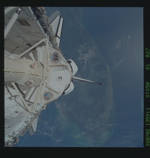
Image Caption: Most of south Florida and the space shuttle payload bay (27.0N, 81.0W) can be seen in this view. The first United States Microgravity Laboratory (USML-1) module is pictured in the payload bay of the earth-orbiting Columbia in this scene over the southern two-thirds of the Florida peninsula. The Kennedy Space Center, where the mission began, can be seen just above Columbia's starboard wing.
