STS049-97-020
| NASA Photo ID | STS049-97-020 |
| Focal Length | 250mm |
| Date taken | 1992.05.12 |
| Time taken | 22:21:28 GMT |

Cloud masks available for this image:
Spacecraft nadir point: 27.5° N, 82.8° W
Photo center point: 28.0° N, 82.5° W
Photo center point by machine learning:
Photo center point: 28.0° N, 82.5° W
Photo center point by machine learning:
Nadir to Photo Center: Northeast
Spacecraft Altitude: 196 nautical miles (363km)
Country or Geographic Name: | USA-FLORIDA |
Features: | CLEARWATER, ST. PETE |
| Features Found Using Machine Learning: | |
Cloud Cover Percentage: | 5 (1-10)% |
Sun Elevation Angle: | 23° |
Sun Azimuth: | 280° |
Camera: | Hasselblad |
Focal Length: | 250mm |
Camera Tilt: | 10 degrees |
Format: | 5017: Kodak, natural color positive, Ektachrome, X Professional, ASA 64, standard base |
Film Exposure: | Normal |
| Additional Information | |
| Width | Height | Annotated | Cropped | Purpose | Links |
|---|---|---|---|---|---|
| 5700 pixels | 6000 pixels | No | No | Download Image | |
| 500 pixels | 526 pixels | No | No | Download Image | |
| 640 pixels | 480 pixels | No | No | Download Image |
Download Packaged File
Download a Google Earth KML for this Image
View photo footprint information
Download a GeoTIFF for this photo
Image Caption:
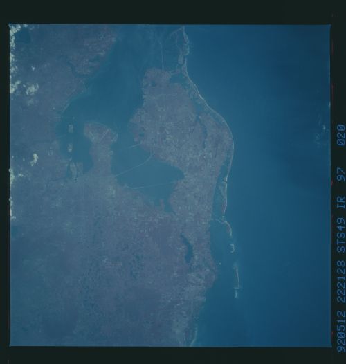
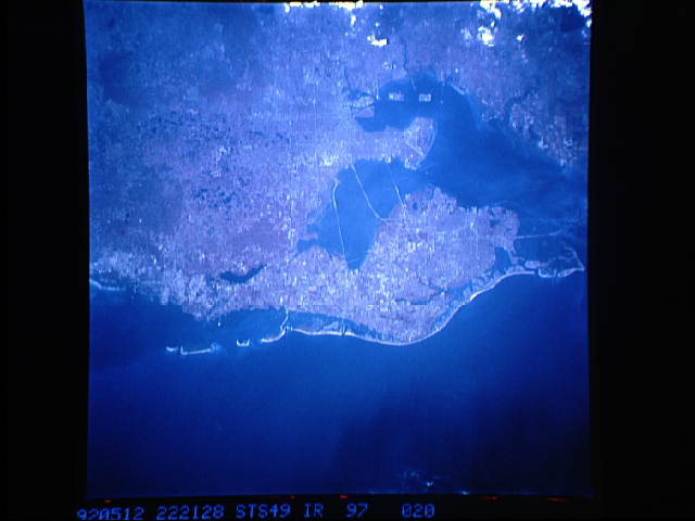
STS049-92-017 (CVIS) & STS049-97-020 (CIR) - Tampa Bay
Color (CVIS) and color infrared (CIR) photographs of Tampa Bay,
Florida, provide different information about the natural and
built features of the area. The city of Tampa is to the east;
bridges linking it to St. Petersburg show clearly, as do runways
at MacDill Air Force Base at the end of the peninsula projecting
into the bay. The color photograph lacks the apparent clarity of
the color infrared photo taken at the same time. For example,
land-water boundaries, while discernible on both film types, are
much easier to discriminate on the CIR photograph. The haze
penetration capability of the CIR film is also evident. The
color film does tend to convey slightly more information on water
color and sedimentation than does the CIR film.
This photo of the Tampa Bay, St. Petersburg, Florida (28.0N, 82.5W) is one of a pair (see STS049-92-017) to compare the differences between color film and color infrared film. In the color image above, the scene appears as it would to the human eye. The city of St. Petersburg can be seen even though there is atmospheric haze obscuring the image. Color infrared film filters out the haze and portrays vegetation as shades of red or pink.
