STS049-94-23
| NASA Photo ID | STS049-94-23 |
| Focal Length | 250mm |
| Date taken | 1992.05.09 |
| Time taken | 05:21:36 GMT |
Resolutions offered for this image:
3955 x 3918 pixels 640 x 634 pixels 5700 x 6000 pixels 500 x 526 pixels 640 x 480 pixels
3955 x 3918 pixels 640 x 634 pixels 5700 x 6000 pixels 500 x 526 pixels 640 x 480 pixels
Cloud masks available for this image:
Spacecraft nadir point: 19.7° S, 55.7° E
Photo center point: 21.0° S, 55.5° E
Photo center point by machine learning:
Photo center point: 21.0° S, 55.5° E
Photo center point by machine learning:
Nadir to Photo Center: South
Spacecraft Altitude: 178 nautical miles (330km)
Country or Geographic Name: | REUNION |
Features: | WHOLE ISLAND |
| Features Found Using Machine Learning: | |
Cloud Cover Percentage: | 30 (26-50)% |
Sun Elevation Angle: | 34° |
Sun Azimuth: | 52° |
Camera: | Hasselblad |
Focal Length: | 250mm |
Camera Tilt: | 24 degrees |
Format: | 5017: Kodak, natural color positive, Ektachrome, X Professional, ASA 64, standard base |
Film Exposure: | Normal |
| Additional Information | |
| Width | Height | Annotated | Cropped | Purpose | Links |
|---|---|---|---|---|---|
| 3955 pixels | 3918 pixels | No | No | Earth From Space collection | Download Image |
| 640 pixels | 634 pixels | No | No | Earth From Space collection | Download Image |
| 5700 pixels | 6000 pixels | No | No | Download Image | |
| 500 pixels | 526 pixels | No | No | Download Image | |
| 640 pixels | 480 pixels | No | No | Download Image |
Download Packaged File
Download a Google Earth KML for this Image
View photo footprint information
Download a GeoTIFF for this photo
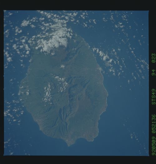
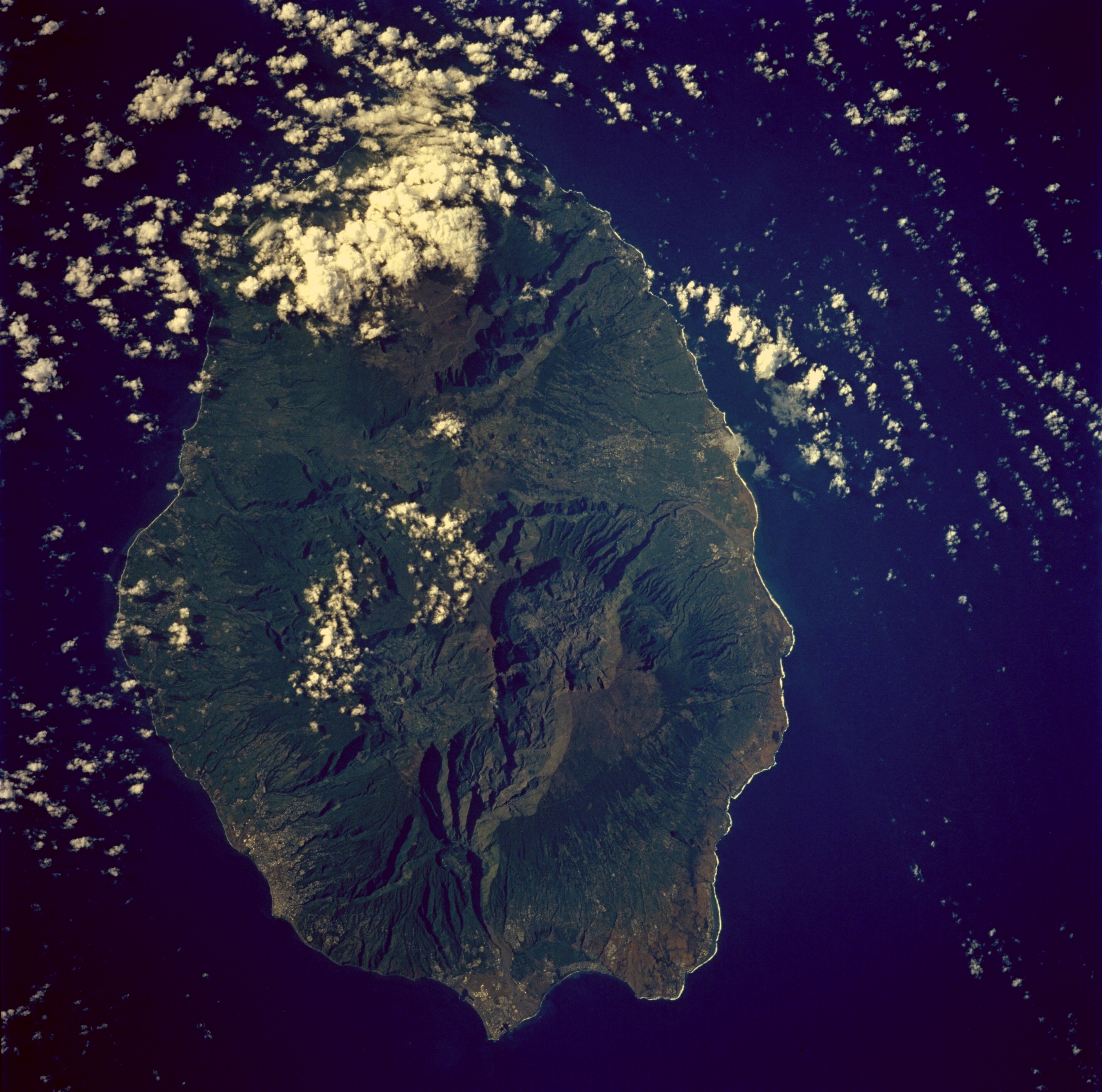
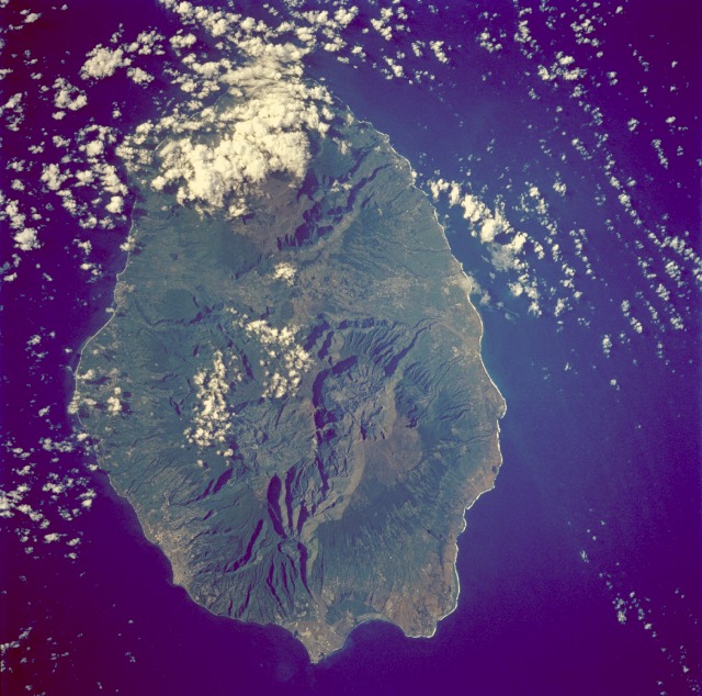
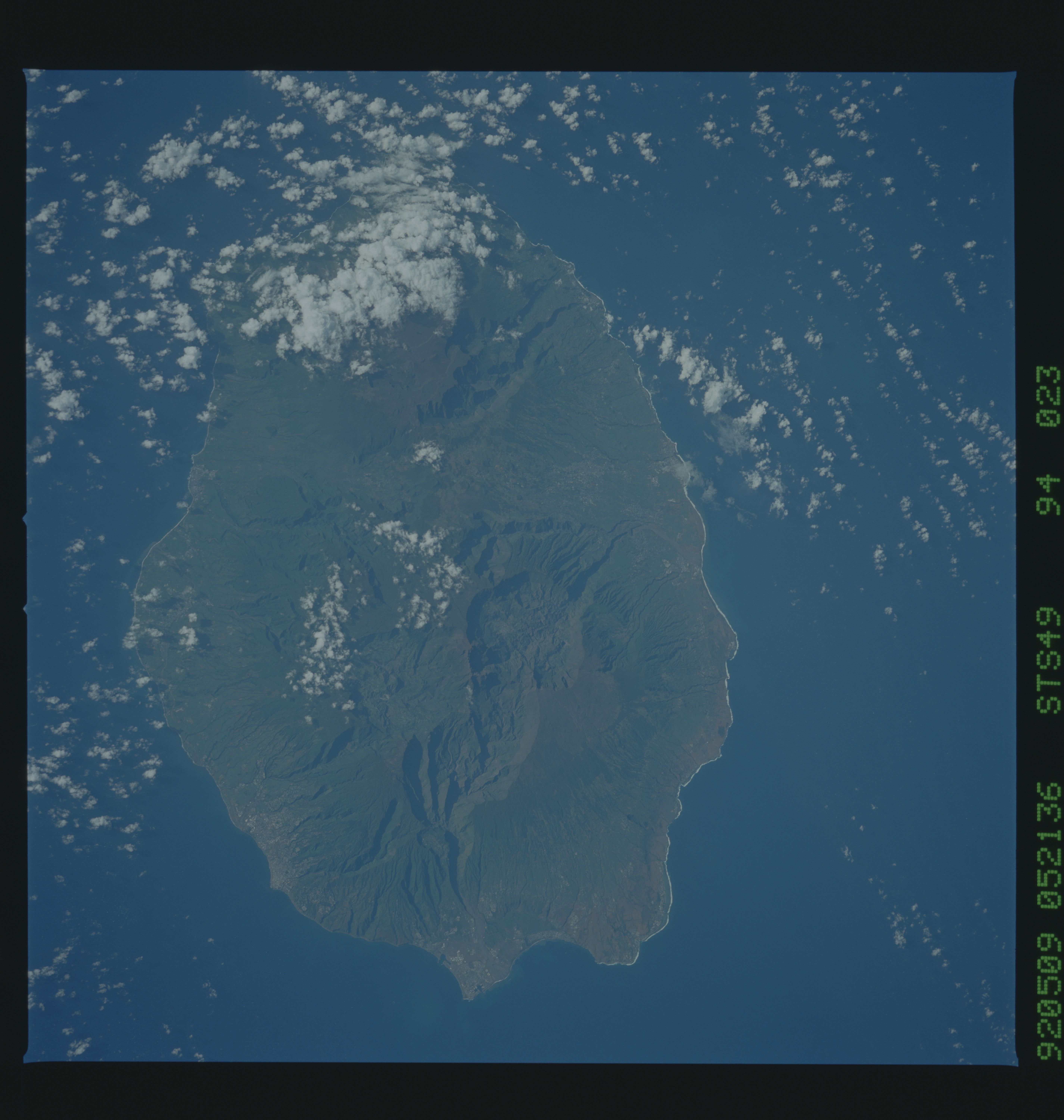
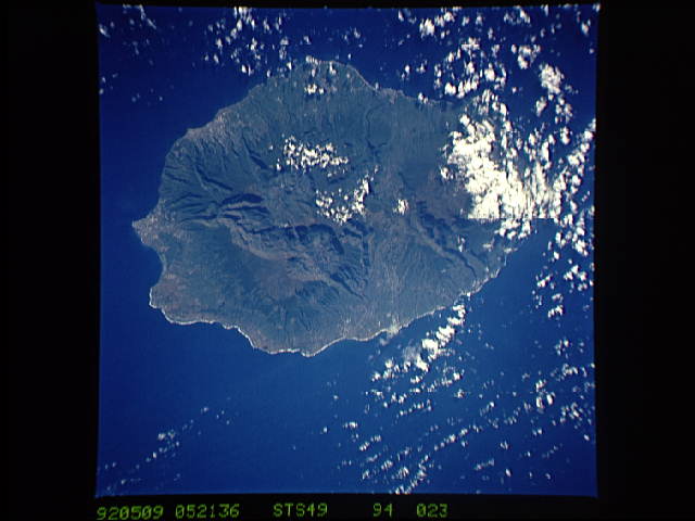
Image Caption: STS049-094-023 Réunion Island May 1992
Oval-shaped Réunion Island, one of the Mascarene Islands, is shown in this low-oblique, southeast-looking photograph. The island is 39 miles (63 kilometers) long, is 28 miles (45 kilometers) wide, and covers 970 square miles (2150 square kilometers). The island is similar to the big island of Hawaii because both are located above hot spots in the Earth's crust. Piton de la Fournaise, a shield volcano on the eastern end of Réunion Island, is partially obscured by clouds in this photograph. The volcano, which rises more than 8565 feet (2611 meters) above sea level and is sometimes called a sister to Hawaiian volcanoes because of the similarity of climate and volcanic nature, has erupted more than 100 times since 1640. The brown volcanic flows are visible in the photograph. Piton des Neiges Volcano, the highest point on the island at 10 069 feet (3070 meters) above sea level, is west of Piton de la Fournaise Volcano near the center of the photograph. Collapsed calderas and canyons are southwest of the mountain. Like Mauna Kea on the big island of Hawaii, Piton des Neiges is extinct. The slopes of both volcanoes are heavily forested (dark green). Cultivated land and cities like the capital city of Saint-Denis are concentrated on the surrounding coastal lowlands. Sugar is the chief agricultural product and export.
Oval-shaped Réunion Island, one of the Mascarene Islands, is shown in this low-oblique, southeast-looking photograph. The island is 39 miles (63 kilometers) long, is 28 miles (45 kilometers) wide, and covers 970 square miles (2150 square kilometers). The island is similar to the big island of Hawaii because both are located above hot spots in the Earth's crust. Piton de la Fournaise, a shield volcano on the eastern end of Réunion Island, is partially obscured by clouds in this photograph. The volcano, which rises more than 8565 feet (2611 meters) above sea level and is sometimes called a sister to Hawaiian volcanoes because of the similarity of climate and volcanic nature, has erupted more than 100 times since 1640. The brown volcanic flows are visible in the photograph. Piton des Neiges Volcano, the highest point on the island at 10 069 feet (3070 meters) above sea level, is west of Piton de la Fournaise Volcano near the center of the photograph. Collapsed calderas and canyons are southwest of the mountain. Like Mauna Kea on the big island of Hawaii, Piton des Neiges is extinct. The slopes of both volcanoes are heavily forested (dark green). Cultivated land and cities like the capital city of Saint-Denis are concentrated on the surrounding coastal lowlands. Sugar is the chief agricultural product and export.
