STS048-152-7
| NASA Photo ID | STS048-152-7 |
| Focal Length | 250mm |
| Date taken | 1991.09.14 |
| Time taken | 08:04:25 GMT |
Resolutions offered for this image:
640 x 480 pixels
640 x 480 pixels
Cloud masks available for this image:
Spacecraft nadir point: 53.6° S, 3.0° E
Photo center point:
Photo center point by machine learning:
Photo center point:
Photo center point by machine learning:
Nadir to Photo Center:
Spacecraft Altitude: 314 nautical miles (582km)
Camera: | Linhof |
Focal Length: | 250mm |
Camera Tilt: | Low Oblique |
Format: | QX868: Kodak, natural color positive, Ektachrome QX868(5017 emulsion), ASA 64, thin base |
Film Exposure: | Normal |
| Additional Information | |
| Width | Height | Annotated | Cropped | Purpose | Links |
|---|---|---|---|---|---|
| 640 pixels | 480 pixels | No | No | ISD 1 | Download Image |
Download Packaged File
Download a Google Earth KML for this Image
View photo footprint information
Download a GeoTIFF for this photo
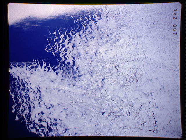
Image Caption: Breakup of Pack Ice along the periphery of the Antarctic Ice Shelf (53.5S, 3.0E) produced this mosaic of ice floes off the Antarctic Ice Shelf. Strong offshore winds, probably associated with strong katabatic downdrafts from the interior of the continent, are seen peeling off the edges of the ice shelf into long filamets of sea ice, icebergs, bergy bits and growlers to flow northward into the South Atlantic Ocean. 53.5S, 3.0E
