STS047-153-271
| NASA Photo ID | STS047-153-271 |
| Focal Length | 90mm |
| Date taken | 1992.09.16 |
| Time taken | 06:03:27 GMT |
Resolutions offered for this image:
640 x 480 pixels
640 x 480 pixels
Cloud masks available for this image:
Spacecraft nadir point: 36.2° N, 32.7° E
Photo center point: 35.5° N, 33.0° E
Photo center point by machine learning:
Photo center point: 35.5° N, 33.0° E
Photo center point by machine learning:
Nadir to Photo Center: South
Spacecraft Altitude: 167 nautical miles (309km)
Country or Geographic Name: | CYPRUS |
Features: | ENTIRE I., CIRCULAR CL. |
| Features Found Using Machine Learning: | |
Cloud Cover Percentage: | 5 (1-10)% |
Sun Elevation Angle: | 21° |
Sun Azimuth: | 97° |
Camera: | Linhof |
Focal Length: | 90mm |
Camera Tilt: | 15 degrees |
Format: | QX868: Kodak, natural color positive, Ektachrome QX868(5017 emulsion), ASA 64, thin base |
Film Exposure: | Normal |
| Additional Information | |
| Width | Height | Annotated | Cropped | Purpose | Links |
|---|---|---|---|---|---|
| 640 pixels | 480 pixels | No | No | ISD 1 | Download Image |
Download Packaged File
Download a Google Earth KML for this Image
View photo footprint information
Download a GeoTIFF for this photo
Image Caption:
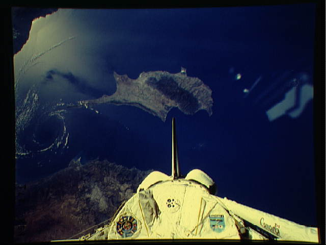
Cloud-Free Vortex Near Cyprus STS047-153-271 (east)
STS047-153-271 (west) 9/16/92
06:03:27GMT Cloud-free meteorological phenomena are almost never
observed in the environmental satellite imagery. Shuttle color
photography and the human observer are uniquely qualified to
identify and document these subtle features which would otherwise
go unnoticed.
