STS047-151-643
| NASA Photo ID | STS047-151-643 |
| Focal Length | 90mm |
| Date taken | 1992.09.19 |
| Time taken | 12:36:31 GMT |
Resolutions offered for this image:
640 x 480 pixels
640 x 480 pixels
Cloud masks available for this image:
Spacecraft nadir point: 48.0° N, 66.1° W
Photo center point:
Photo center point by machine learning:
Photo center point:
Photo center point by machine learning:
Nadir to Photo Center:
Spacecraft Altitude: 168 nautical miles (311km)
Camera: | Linhof |
Focal Length: | 90mm |
Camera Tilt: | High Oblique |
Format: | QX868: Kodak, natural color positive, Ektachrome QX868(5017 emulsion), ASA 64, thin base |
Film Exposure: | Normal |
| Additional Information | |
| Width | Height | Annotated | Cropped | Purpose | Links |
|---|---|---|---|---|---|
| 640 pixels | 480 pixels | No | No | ISD 1 | Download Image |
Download Packaged File
Download a Google Earth KML for this Image
View photo footprint information
Download a GeoTIFF for this photo
Image Caption:
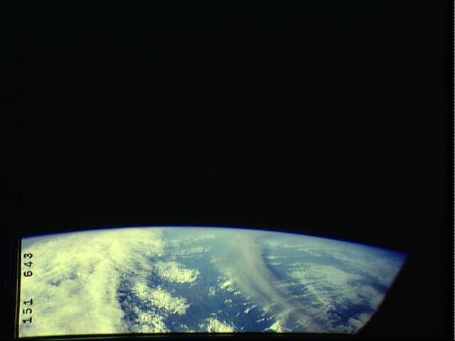
STS047-151-643 Mt Spurr ash GMT 9/19 12:36:31. Mt Spurr, on the
northern end of the Alaskan Peninsula, erupted on September 17,
1992. The large ash plume was easily visible on environmental sa-
tellites, and started to move east from the mountain. Although
the STS047 south-looking attitude prevented the crew from viewing
the ash right after the eruption, they caught up with the long,
dark ash cloud roughly 2 days later. This photograph of the ash
cloud was taken over eastern Quebec and views west.
Mt. Spurr Volcano Ash Pall
STS047-151-643
9/19/92 12:36:31GMT
Mt Spurr (61.3N 152.2W) erupted on Sep 16th at 06:36 and 08:04GMT
ejecting an ash pall which came into the Shuttle's fields of view
on the 19th as shown here. (see also graphic)
