STS045-87-3
| NASA Photo ID | STS045-87-3 |
| Focal Length | 50mm |
| Date taken | 1992.03.30 |
| Time taken | 05:09:36 GMT |


Cloud masks available for this image:
Spacecraft nadir point: 55.3° N, 99.9° E
Photo center point: 51.0° N, 100.0° E
Photo center point by machine learning:
Photo center point: 51.0° N, 100.0° E
Photo center point by machine learning:
Nadir to Photo Center: South
Spacecraft Altitude: 164 nautical miles (304km)
Country or Geographic Name: | MONGOLIA |
Features: | PAN-RIVERS, LAKE BAIKAL |
| Features Found Using Machine Learning: | |
Cloud Cover Percentage: | 60 (51-75)% |
Sun Elevation Angle: | 38° |
Sun Azimuth: | 175° |
Camera: | Hasselblad |
Focal Length: | 50mm |
Camera Tilt: | High Oblique |
Format: | 5017: Kodak, natural color positive, Ektachrome, X Professional, ASA 64, standard base |
Film Exposure: | Normal |
| Additional Information | |
| Width | Height | Annotated | Cropped | Purpose | Links |
|---|---|---|---|---|---|
| 5700 pixels | 6000 pixels | No | No | Download Image | |
| 500 pixels | 526 pixels | No | No | Download Image | |
| 640 pixels | 480 pixels | No | No | Download Image |
Download Packaged File
Download a Google Earth KML for this Image
View photo footprint information
Download a GeoTIFF for this photo
Image Caption:
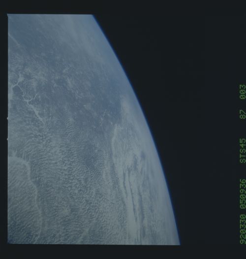
STS045-87-003: Upper Lena River Basin, Eastern Siberia Upper
Lena River basin (eastern Siberia) is seen here through a very
clear atmosphere which shows the great bend of the Lena at 60! N
and points at least three degrees further north. The Lena flows
into the Arctic Ocean. Lake Baikal appears right with the Stana-
voi Range. In the foreground is the Ust'-Ilimskiy Reservoir on
the Angora River, a tributary of the Lena.
