STS045-78-16
| NASA Photo ID | STS045-78-16 |
| Focal Length | 100mm |
| Date taken | 1992.03.26 |
| Time taken | 21:32:07 GMT |

Cloud masks available for this image:
Spacecraft nadir point: 25.8° N, 76.0° W
Photo center point: 26.5° N, 80.0° W
Photo center point by machine learning:
Photo center point: 26.5° N, 80.0° W
Photo center point by machine learning:
Nadir to Photo Center: West
Spacecraft Altitude: 162 nautical miles (300km)
Camera: | Hasselblad |
Focal Length: | 100mm |
Camera Tilt: | High Oblique |
Format: | 5017: Kodak, natural color positive, Ektachrome, X Professional, ASA 64, standard base |
Film Exposure: | Normal |
| Additional Information | |
| Width | Height | Annotated | Cropped | Purpose | Links |
|---|---|---|---|---|---|
| 5700 pixels | 6000 pixels | No | No | Download Image | |
| 500 pixels | 526 pixels | No | No | Download Image | |
| 640 pixels | 480 pixels | No | No | Download Image |
Download Packaged File
Download a Google Earth KML for this Image
View photo footprint information
Download a GeoTIFF for this photo
Image Caption:
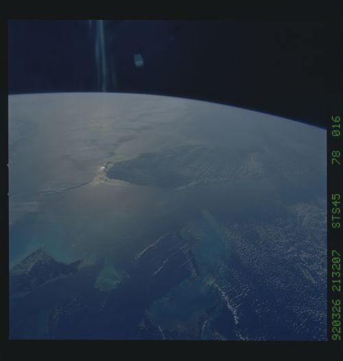
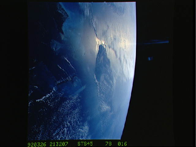
STS045-78-016: Bahamas and Florida The view is westward into the
sunglint. The Bahama Banks are in the foreground; from left to
right, Andros Island, the Berry Islands, and Grand Bahama Island
are surrounded by shallow limestone banks. Bimini is the double
dark spot on the edge of the Straits of Florida, with the penin-
sula of Florida within the sunglint. Cuba can be seen to the
upper left.
This view is of the Bahamas and Florida (26.5N, 80.0W) looking westward into the sunglint of the setting sun. The Bahama Banks are in the foreground; from left to right, Andros Island (the largest), the Berry Islands and Grand Bahama Island are surrounded by the shallow limestone banks. Bimini is the two small islands between Florida and the Bahamas. The western tip of Cuba is at the edge of the scene.
