STS045-152-192
| NASA Photo ID | STS045-152-192 |
| Focal Length | 250mm |
| Date taken | 1992.03.30 |
| Time taken | 15:34:34 GMT |
Resolutions offered for this image:
640 x 480 pixels
640 x 480 pixels
Cloud masks available for this image:
Spacecraft nadir point: 53.3° N, 109.2° W
Photo center point: 48.0° N, 115.0° W
Photo center point by machine learning:
Photo center point: 48.0° N, 115.0° W
Photo center point by machine learning:
Nadir to Photo Center: Southwest
Spacecraft Altitude: 162 nautical miles (300km)
Country or Geographic Name: | USA-MONTANA |
Features: | FLATHEAD MTS., VERY DARK |
| Features Found Using Machine Learning: | |
Cloud Cover Percentage: | 15 (11-25)% |
Sun Elevation Angle: | 23° |
Sun Azimuth: | 115° |
Camera: | Linhof |
Focal Length: | 250mm |
Camera Tilt: | High Oblique |
Format: | QX868: Kodak, natural color positive, Ektachrome QX868(5017 emulsion), ASA 64, thin base |
Film Exposure: | Under Exposed |
| Additional Information | |
| Width | Height | Annotated | Cropped | Purpose | Links |
|---|---|---|---|---|---|
| 640 pixels | 480 pixels | No | No | ISD 1 | Download Image |
Download Packaged File
Download a Google Earth KML for this Image
View photo footprint information
Download a GeoTIFF for this photo
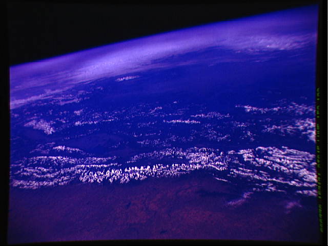
Image Caption:
STS045-152-192: Rocky Mountain Front Range A view southwestward
across the Rocky Mountains in northern Montana and southern
Alberta. Glacier National Park is in the center of the snow-
covered Front Range. Beyond and to the left, Flathead Lake, sur-
rounded by dark forest, can barely be made out within the light-
colored valley. The view extends across the Columbia River Basin
in Oregon to the eastern Cascades. Fallow wheat land on the
northern High Plains in the foreground awaits the spring.
STS-45 Earth observation taken onboard Atlantis, Orbiter Vehicle (OV) 104, is of the Rocky Mountains in northern Montana and southern Alberta. Glacier National Park is in the center of the snow-covered Front Range. Beyond and to the left, Flathead Lake, surrounded by dark forest, can barely be made out within the light-colored valley. This view extends across the Columbia River Basin in Oregon to the eastern Cascades. Fallow wheat land on the northern High Plains is visible in the foreground.
