STS041-83-98
| NASA Photo ID | STS041-83-98 |
| Focal Length | 50mm |
| Date taken | 1990.10.10 |
| Time taken | 06:26:50 GMT |

Cloud masks available for this image:
Spacecraft nadir point: 9.1° N, 42.8° E
Photo center point: 11.5° N, 40.5° E
Photo center point by machine learning:
Photo center point: 11.5° N, 40.5° E
Photo center point by machine learning:
Nadir to Photo Center: Northwest
Spacecraft Altitude: 162 nautical miles (300km)
Country or Geographic Name: | DJIBOUTI |
Features: | AFAR DEPRESSION |
| Features Found Using Machine Learning: | |
Cloud Cover Percentage: | 10 (1-10)% |
Sun Elevation Angle: | 49° |
Sun Azimuth: | 111° |
Camera: | Hasselblad |
Focal Length: | 50mm |
Camera Tilt: | 51 degrees |
Format: | 5017: Kodak, natural color positive, Ektachrome, X Professional, ASA 64, standard base |
Film Exposure: | Normal |
| Additional Information | |
| Width | Height | Annotated | Cropped | Purpose | Links |
|---|---|---|---|---|---|
| 5614 pixels | 6000 pixels | No | No | Download Image | |
| 500 pixels | 534 pixels | No | No | Download Image | |
| 640 pixels | 480 pixels | No | No | Download Image |
Download Packaged File
Download a Google Earth KML for this Image
View photo footprint information
Download a GeoTIFF for this photo
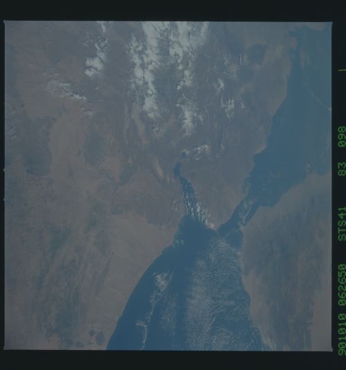
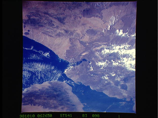
Image Caption: STS41-83-098 and STS029-87-070 Bab el Mandeb Strait These two views
show the Bab el Mandeb ("The Gate of Tears"), the strategic strait
that separates the Red Sea from the Gulf of Aden. Perm Island (1),
visible on the bottom left view, divides the strait in two: Large
Strait and Small Strait. For most ship traffic, Large Strait is used
because it is much safer to navigate. The Bab el Mandeb is 27.4 km
wide and in Large Strait, 322 meters deep. The straits' strategic
importance began with the opening of the Suez Canal. The strait takes
in territorial waters of four coastal states: North and South Yemen,
Djibouti, and Ethiopia. About 60 ships a day pass through, but only 15
percent of Western Europe's oil supplies are transported via the
strait. The strait is of great importance to the Suez Canal, to Israel
for the port of Eilat, and to the Red Sea littoral States.
