STS041-75-31
| NASA Photo ID | STS041-75-31 |
| Focal Length | 250mm |
| Date taken | 1990.10.07 |
| Time taken | 09:12:55 GMT |


Cloud masks available for this image:
Spacecraft nadir point: 17.3° N, 8.0° E
Photo center point: 17.5° N, 8.5° E
Photo center point by machine learning:
Photo center point: 17.5° N, 8.5° E
Photo center point by machine learning:
Nadir to Photo Center: East
Spacecraft Altitude: 161 nautical miles (298km)
Country or Geographic Name: | NIGER |
Features: | AIR MOUNTAINS |
| Features Found Using Machine Learning: | |
Cloud Cover Percentage: | 0 (no clouds present) |
Sun Elevation Angle: | 52° |
Sun Azimuth: | 124° |
Camera: | Hasselblad |
Focal Length: | 250mm |
Camera Tilt: | 11 degrees |
Format: | 5017: Kodak, natural color positive, Ektachrome, X Professional, ASA 64, standard base |
Film Exposure: | Normal |
| Additional Information | |
| Width | Height | Annotated | Cropped | Purpose | Links |
|---|---|---|---|---|---|
| 5700 pixels | 5900 pixels | No | No | Download Image | |
| 500 pixels | 518 pixels | No | No | Download Image | |
| 640 pixels | 480 pixels | No | No | Download Image |
Download Packaged File
Download a Google Earth KML for this Image
View photo footprint information
Download a GeoTIFF for this photo
Image Caption:
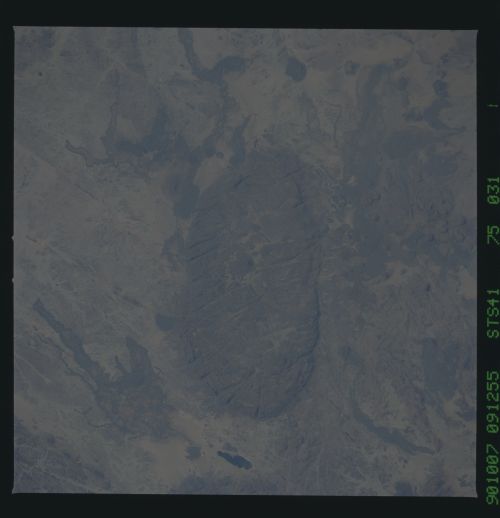
Mount Bagzan, Air Mountains T39
Mount Bagzan in the Southern Air Mountains can be seen in this
near vertical view taken in October, 1990. Several lava flows
and much faulting are also visible. Mount Bagzan is unique among
the Air Mountains because it has good water resources and sup-
ports a permanent farming population. Its irrigation system
dates back to ancient times. Winds and occasional heavy summer
rains help continue the ongoing erosion process. (S41-75-031)
