STS041-152-90
| NASA Photo ID | STS041-152-90 |
| Focal Length | 250mm |
| Date taken | 1990.10.09 |
| Time taken | 06:47:40 GMT |

Cloud masks available for this image:
Spacecraft nadir point: 27.5° S, 136.5° E
Photo center point: 28.5° S, 137.0° E
Photo center point by machine learning:
Photo center point: 28.5° S, 137.0° E
Photo center point by machine learning:
Nadir to Photo Center: South
Spacecraft Altitude: 159 nautical miles (294km)
Country or Geographic Name: | AUSTRALIA-SA |
Features: | NEALES R, N. LAKE EYRE. |
| Features Found Using Machine Learning: | |
Cloud Cover Percentage: | 0 (no clouds present) |
Sun Elevation Angle: | 28° |
Sun Azimuth: | 277° |
Camera: | Linhof |
Focal Length: | 250mm |
Camera Tilt: | 23 degrees |
Format: | QX868: Kodak, natural color positive, Ektachrome QX868(5017 emulsion), ASA 64, thin base |
Film Exposure: | Normal |
| Additional Information | |
| Width | Height | Annotated | Cropped | Purpose | Links |
|---|---|---|---|---|---|
| 5056 pixels | 3968 pixels | No | No | Earth From Space collection | Download Image |
| 640 pixels | 502 pixels | No | No | Earth From Space collection | Download Image |
| 640 pixels | 480 pixels | No | No | ISD 1 | Download Image |
Download Packaged File
Download a Google Earth KML for this Image
View photo footprint information
Download a GeoTIFF for this photo
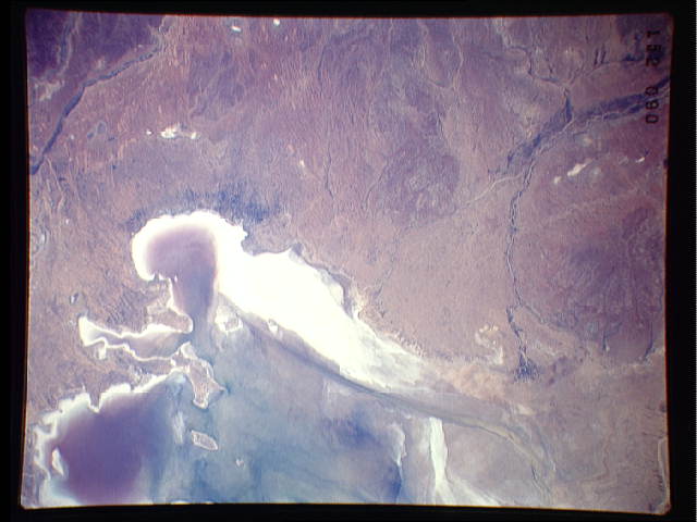
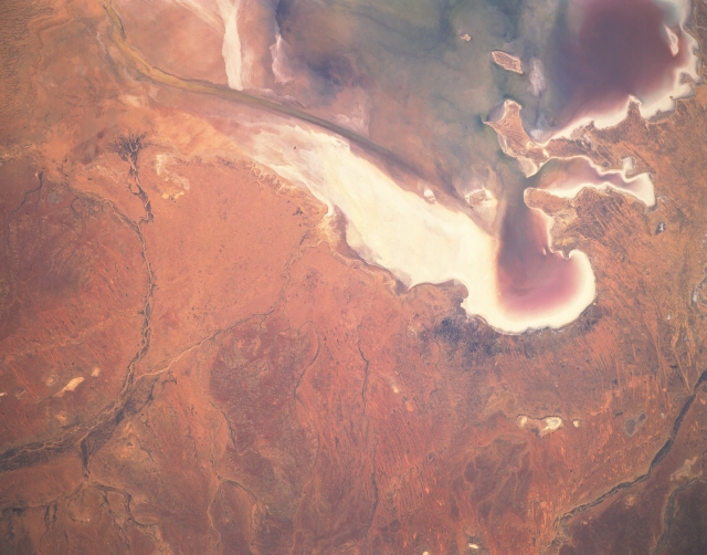
Image Caption: STS041-152-090 Lake Eyre, South Australia, Australia October 1990
The normally dry lake bed of Lake Eyre forms a 50-mile (80 km) long salt flat in the southwestern Simpson Desert of South Australia. This picture shows the three bays that are located along the southern end of the northern basin of Lake Eyre: Madigan Bay is the largest (southeast); Belt Bay is in the southwest corner of the lake; and Jackboot Bay is the smaller, elongate feature between the other two. The darker colors within each of the bays shows that moisture, perhaps even some standing water, is present in several parts of the lake, especially in the three bays. The darker, smooth-looking, narrow feature near the western edge of the lake and terminates in Belt Bay is known as the "Warburton Groove". The groove is a fault-controlled stream channel that transports water from the northern to the southern part of the lake. The curving, dark line along the left side of the image is the Neales River, an intermittent stream that periodically feeds water into the northwest side of Lake Eyre. Notice that this river has even built a fan-shaped delta (dark pattern) near the north end of Warburton Groove. The highly reflective surfaces are salt deposits resulting from evaporation of saline waters from the shallow lake.
The normally dry lake bed of Lake Eyre forms a 50-mile (80 km) long salt flat in the southwestern Simpson Desert of South Australia. This picture shows the three bays that are located along the southern end of the northern basin of Lake Eyre: Madigan Bay is the largest (southeast); Belt Bay is in the southwest corner of the lake; and Jackboot Bay is the smaller, elongate feature between the other two. The darker colors within each of the bays shows that moisture, perhaps even some standing water, is present in several parts of the lake, especially in the three bays. The darker, smooth-looking, narrow feature near the western edge of the lake and terminates in Belt Bay is known as the "Warburton Groove". The groove is a fault-controlled stream channel that transports water from the northern to the southern part of the lake. The curving, dark line along the left side of the image is the Neales River, an intermittent stream that periodically feeds water into the northwest side of Lake Eyre. Notice that this river has even built a fan-shaped delta (dark pattern) near the north end of Warburton Groove. The highly reflective surfaces are salt deposits resulting from evaporation of saline waters from the shallow lake.
