STS040-80-16

| NASA Photo ID | STS040-80-16 |
| Focal Length | 250mm |
| Date taken | 1991.06.10 |
| Time taken | 16:51:03 GMT |
Resolutions offered for this image:
3948 x 3962 pixels 637 x 639 pixels 5700 x 6000 pixels 500 x 526 pixels 640 x 480 pixels
3948 x 3962 pixels 637 x 639 pixels 5700 x 6000 pixels 500 x 526 pixels 640 x 480 pixels

Cloud masks available for this image:
Spacecraft nadir point: 39.1° N, 119.5° W
Photo center point: 39.0° N, 120.0° W
Photo center point by machine learning:
Photo center point: 39.0° N, 120.0° W
Photo center point by machine learning:
Nadir to Photo Center: West
Spacecraft Altitude: 153 nautical miles (283km)
Country or Geographic Name: | USA-NEVADA |
Features: | LAKE TAHOE AREA |
| Features Found Using Machine Learning: | |
Cloud Cover Percentage: | 0 (no clouds present) |
Sun Elevation Angle: | 47° |
Sun Azimuth: | 97° |
Camera: | Hasselblad |
Focal Length: | 250mm |
Camera Tilt: | 11 degrees |
Format: | 5017: Kodak, natural color positive, Ektachrome, X Professional, ASA 64, standard base |
Film Exposure: | Normal |
| Additional Information | |
| Width | Height | Annotated | Cropped | Purpose | Links |
|---|---|---|---|---|---|
| 3948 pixels | 3962 pixels | No | No | Earth From Space collection | Download Image |
| 637 pixels | 639 pixels | No | No | Earth From Space collection | Download Image |
| 5700 pixels | 6000 pixels | No | No | Download Image | |
| 500 pixels | 526 pixels | No | No | Download Image | |
| 640 pixels | 480 pixels | No | No | Download Image |
Download Packaged File
Download a Google Earth KML for this Image
View photo footprint information
Download a GeoTIFF for this photo
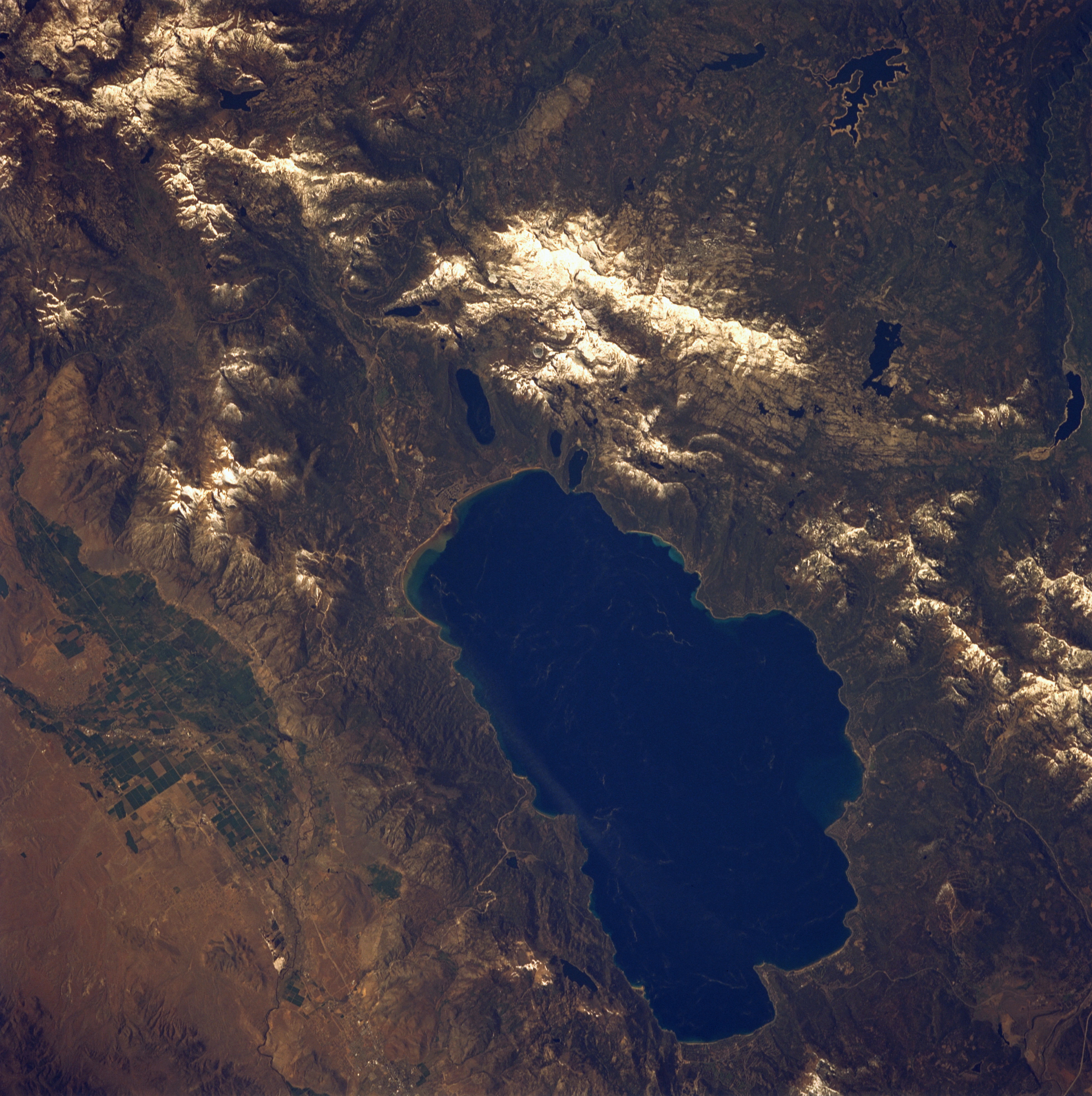
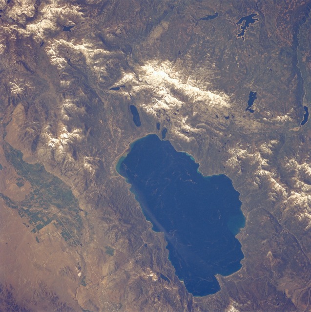
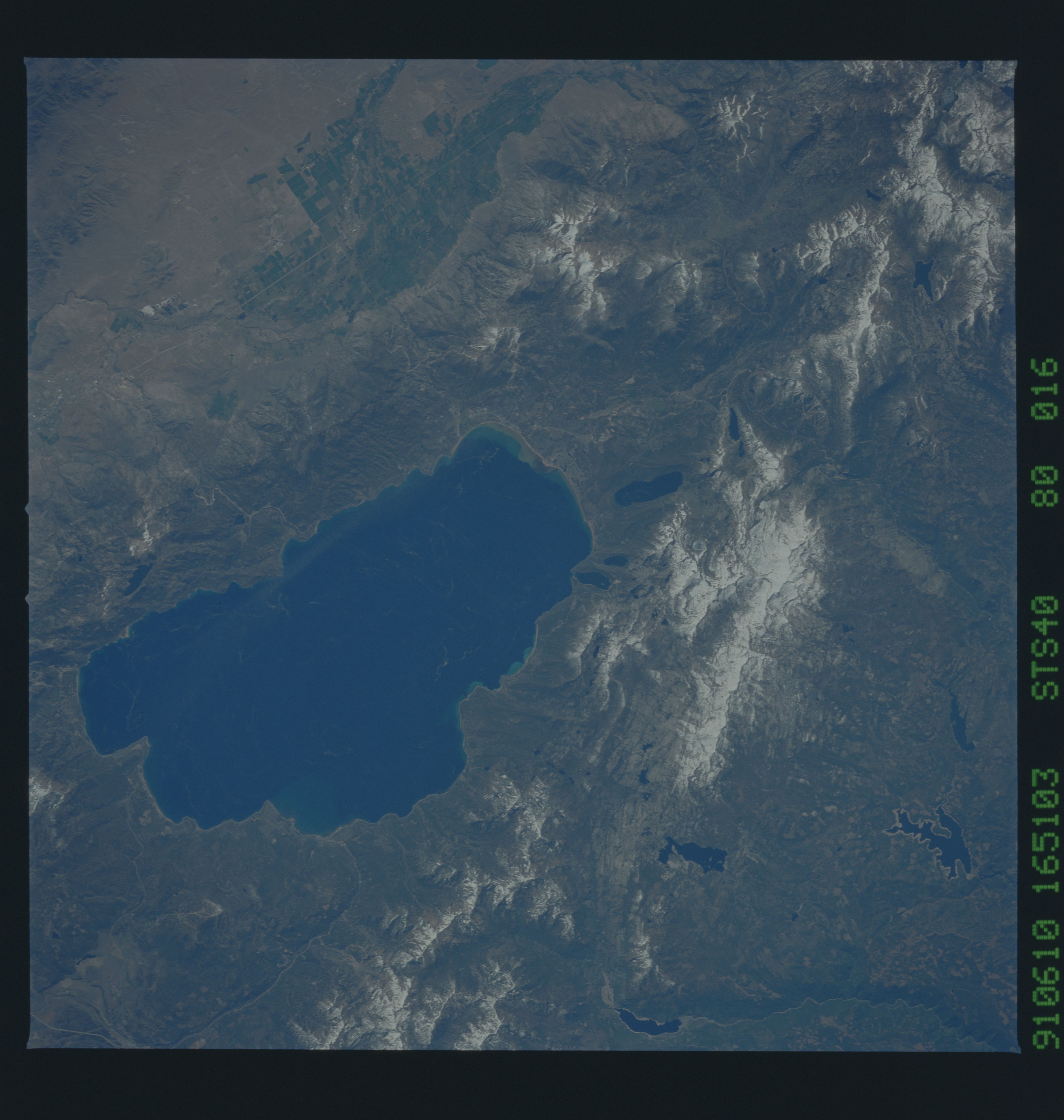
Image Caption: STS040-80-16 Lake Tahoe, California and Nevada, U.S.A. June 1991
The dark blue waters of Lake Tahoe are emphasized in this low-oblique, southwest-looking photograph of a world-famous resort and recreational area. Lake Tahoe is 22 miles (35 kilometers) long and 10 miles (16 kilometers) wide, and it covers 193 square miles (500 square kilometers) on the California-Nevada border. The lake occupies a basin in the forested Sierra Nevada Range, which has snow covering the higher peaks. The lake lies at an altitude of 6228 feet (1900 meters) above sea level; at 1645 feet (502 meters), it is rather deep for a small lake. The Truckee River drains the lake at its northwest end. Visible are irrigated agricultural fields (green) east of Lake Tahoe; Loon Lake west of Lake Tahoe; and Union Valley Reservoir, with its exposed shoreline indicating lowered water levels, southwest of Loon Lake.
The dark blue waters of Lake Tahoe are emphasized in this low-oblique, southwest-looking photograph of a world-famous resort and recreational area. Lake Tahoe is 22 miles (35 kilometers) long and 10 miles (16 kilometers) wide, and it covers 193 square miles (500 square kilometers) on the California-Nevada border. The lake occupies a basin in the forested Sierra Nevada Range, which has snow covering the higher peaks. The lake lies at an altitude of 6228 feet (1900 meters) above sea level; at 1645 feet (502 meters), it is rather deep for a small lake. The Truckee River drains the lake at its northwest end. Visible are irrigated agricultural fields (green) east of Lake Tahoe; Loon Lake west of Lake Tahoe; and Union Valley Reservoir, with its exposed shoreline indicating lowered water levels, southwest of Loon Lake.
