STS040-77-57

| NASA Photo ID | STS040-77-57 |
| Focal Length | 50mm |
| Date taken | 1991.06.06 |
| Time taken | 19:46:29 GMT |
Resolutions offered for this image:
3904 x 3901 pixels 639 x 639 pixels 5700 x 6000 pixels 500 x 526 pixels 640 x 480 pixels
3904 x 3901 pixels 639 x 639 pixels 5700 x 6000 pixels 500 x 526 pixels 640 x 480 pixels


Cloud masks available for this image:
Spacecraft nadir point: 37.8° N, 118.7° W
Photo center point: 37.5° N, 119.0° W
Photo center point by machine learning:
Photo center point: 37.5° N, 119.0° W
Photo center point by machine learning:
Nadir to Photo Center: Southwest
Spacecraft Altitude: 157 nautical miles (291km)
Country or Geographic Name: | USA-CALIFORNIA |
Features: | SIERRA NEVADAS-MONO LAKE |
| Features Found Using Machine Learning: | |
Cloud Cover Percentage: | 0 (no clouds present) |
Sun Elevation Angle: | 74° |
Sun Azimuth: | 173° |
Camera: | Hasselblad |
Focal Length: | 50mm |
Camera Tilt: | 9 degrees |
Format: | 5017: Kodak, natural color positive, Ektachrome, X Professional, ASA 64, standard base |
Film Exposure: | Normal |
| Additional Information | |
| Width | Height | Annotated | Cropped | Purpose | Links |
|---|---|---|---|---|---|
| 3904 pixels | 3901 pixels | No | No | Earth From Space collection | Download Image |
| 639 pixels | 639 pixels | No | No | Earth From Space collection | Download Image |
| 5700 pixels | 6000 pixels | No | No | Download Image | |
| 500 pixels | 526 pixels | No | No | Download Image | |
| 640 pixels | 480 pixels | No | No | Download Image |
Download Packaged File
Download a Google Earth KML for this Image
View photo footprint information
Download a GeoTIFF for this photo
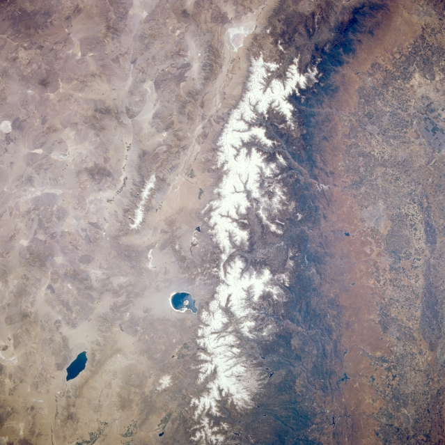
Image Caption: STS040-077-057 Sierra Nevada Mountains, San Joaquin Valley, and Mono Lake, California and Nevada, U.S.A. June 1991
The northwest-southeast-trending, snow-covered Sierra Nevada Mountains are visible in this low-oblique, southeast-looking, synoptic photograph. The western high Sierra Nevadas gently slope downward to the agriculturally rich San Joaquin Valley, evident along the right quarter of the photograph. Near the top center of the photograph are the northern part of the Owens River Valley and Owens Dry Lake. Spring-fed Mono Lake lies east of the snow-covered Sierra Nevadas. The dark blue saline water of Walter Lake is visible near the bottom left of the photograph. Along the left side of the photograph, the basin and range region of western Nevada is discernible.
The northwest-southeast-trending, snow-covered Sierra Nevada Mountains are visible in this low-oblique, southeast-looking, synoptic photograph. The western high Sierra Nevadas gently slope downward to the agriculturally rich San Joaquin Valley, evident along the right quarter of the photograph. Near the top center of the photograph are the northern part of the Owens River Valley and Owens Dry Lake. Spring-fed Mono Lake lies east of the snow-covered Sierra Nevadas. The dark blue saline water of Walter Lake is visible near the bottom left of the photograph. Along the left side of the photograph, the basin and range region of western Nevada is discernible.
