STS040-614-3
| NASA Photo ID | STS040-614-3 |
| Focal Length | 100mm |
| Date taken | 1991.06.__ |
| Time taken | GMT |
Resolutions offered for this image:
3936 x 3901 pixels 639 x 634 pixels 5700 x 6000 pixels 500 x 526 pixels 640 x 480 pixels
3936 x 3901 pixels 639 x 634 pixels 5700 x 6000 pixels 500 x 526 pixels 640 x 480 pixels


Cloud masks available for this image:
Spacecraft nadir point:
Photo center point: 34.5° N, 116.0° W
Photo center point by machine learning:
Photo center point: 34.5° N, 116.0° W
Photo center point by machine learning:
Nadir to Photo Center:
Spacecraft Altitude: nautical miles (0km)
Country or Geographic Name: | USA-CALIFORNIA |
Features: | LK. MEAD, MOJAVE DESERT |
| Features Found Using Machine Learning: | |
Cloud Cover Percentage: | 5 (1-10)% |
Sun Elevation Angle: | ° |
Sun Azimuth: | ° |
Camera: | Rolleiflex |
Focal Length: | 100mm |
Camera Tilt: | Low Oblique |
Format: | 5017: Kodak, natural color positive, Ektachrome, X Professional, ASA 64, standard base |
Film Exposure: | Normal |
| Additional Information | |
| Width | Height | Annotated | Cropped | Purpose | Links |
|---|---|---|---|---|---|
| 3936 pixels | 3901 pixels | No | No | Earth From Space collection | Download Image |
| 639 pixels | 634 pixels | No | No | Earth From Space collection | Download Image |
| 5700 pixels | 6000 pixels | No | No | Download Image | |
| 500 pixels | 526 pixels | No | No | Download Image | |
| 640 pixels | 480 pixels | No | No | Download Image |
Download Packaged File
Download a Google Earth KML for this Image
View photo footprint information
Download a GeoTIFF for this photo
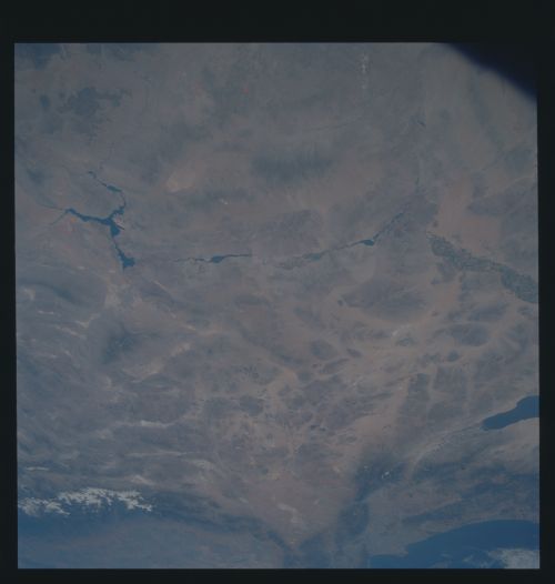
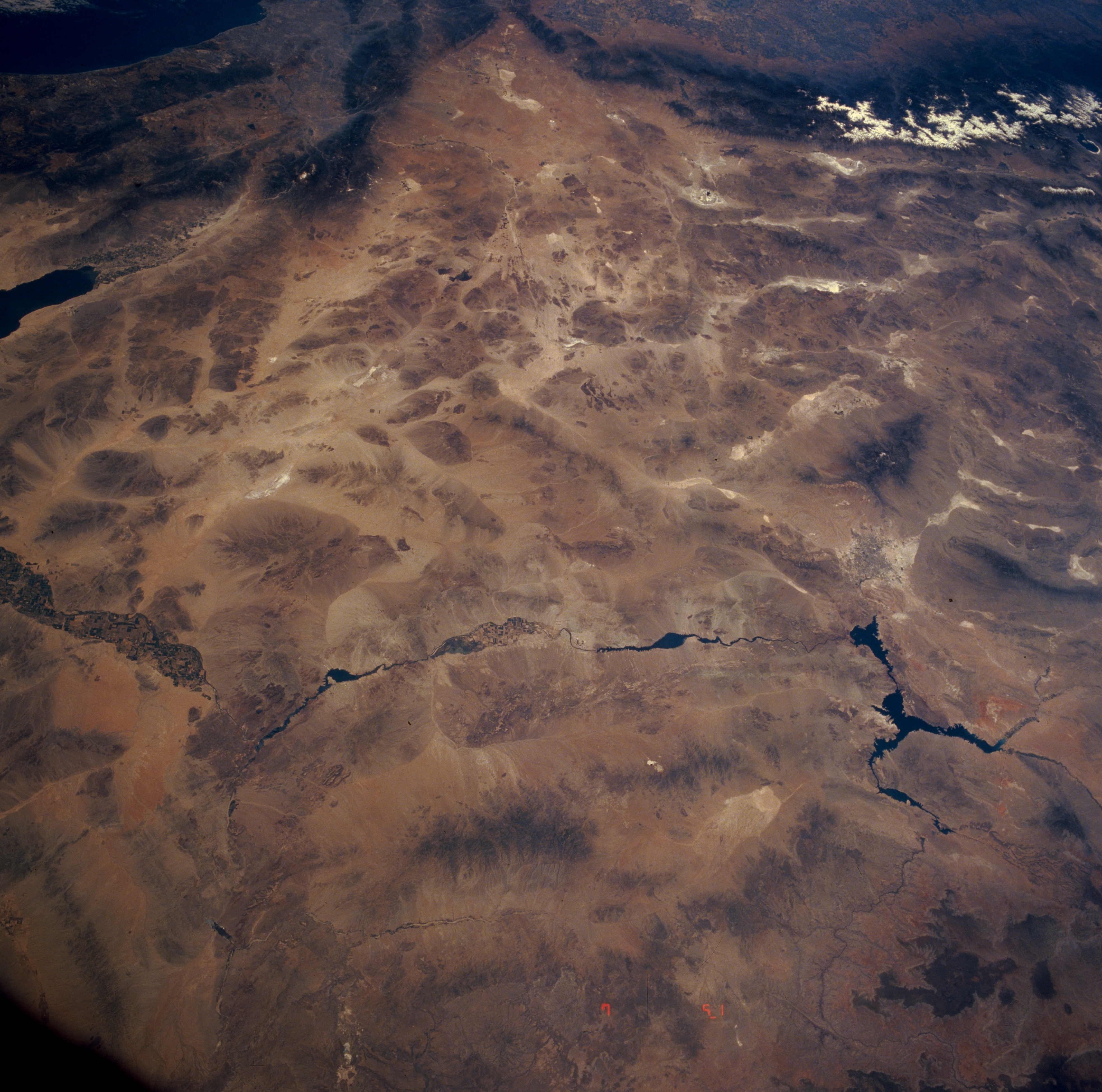
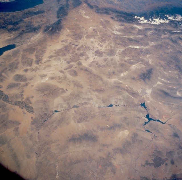
Image Caption: STS040-614-003 Mojave (Mohave) Desert and Colorado River, Arizona, California, and Nevada, U.S.A. June 1991
This west-looking, low-oblique photograph shows a portion of the southern Great Basin of the United States. Visible near the center of the photograph is the great expanse of the Mojave (Mohave) Desert, a region of flat valleys and low, barren mountains with altitudes of 5000 feet (1525 meters). The desert, covering 15 000 square miles (38 850 square kilometers), was part of an ancient, interior sea and was formed by volcanic action and material deposited by the Colorado River. The Mojave, shadowed by the Coast Ranges, receives an average annual rainfall of 5 inches (13 centimeters), most of which occurs during the winter months. Juniper and Joshua trees live on the higher slopes, while desert vegetation and numerous intermittent lakes and streams are present in the valleys. Minerals found in the desert include borax and other salines, gold, silver, and iron. Near the western edge of the photograph, the dry bed of Rogers Lake, the landing site of the Space Shuttle, can be seen. The lower Colorado River, from Lake Mead (near the northern edge of the photograph) to near Yuma, is visible. The Colorado River, 1450 miles (2333 kilometers) long, rises in the Rocky Mountains of northern Colorado and flows generally to the southwest, emptying into the Gulf of California. Today, hardly any water passes through the lower reaches of the Colorado River unless a valve is opened. The Colorado River system of dams and reservoirs controls floods, generates sizable amounts of electricity, provides irrigation and municipal supplies of water, and supports an important recreation industry. Controversies over water rights on the Colorado have long raged between the United States and Mexico, as well as among the bordering states. Treaties and compacts now regulate the river's use.
This west-looking, low-oblique photograph shows a portion of the southern Great Basin of the United States. Visible near the center of the photograph is the great expanse of the Mojave (Mohave) Desert, a region of flat valleys and low, barren mountains with altitudes of 5000 feet (1525 meters). The desert, covering 15 000 square miles (38 850 square kilometers), was part of an ancient, interior sea and was formed by volcanic action and material deposited by the Colorado River. The Mojave, shadowed by the Coast Ranges, receives an average annual rainfall of 5 inches (13 centimeters), most of which occurs during the winter months. Juniper and Joshua trees live on the higher slopes, while desert vegetation and numerous intermittent lakes and streams are present in the valleys. Minerals found in the desert include borax and other salines, gold, silver, and iron. Near the western edge of the photograph, the dry bed of Rogers Lake, the landing site of the Space Shuttle, can be seen. The lower Colorado River, from Lake Mead (near the northern edge of the photograph) to near Yuma, is visible. The Colorado River, 1450 miles (2333 kilometers) long, rises in the Rocky Mountains of northern Colorado and flows generally to the southwest, emptying into the Gulf of California. Today, hardly any water passes through the lower reaches of the Colorado River unless a valve is opened. The Colorado River system of dams and reservoirs controls floods, generates sizable amounts of electricity, provides irrigation and municipal supplies of water, and supports an important recreation industry. Controversies over water rights on the Colorado have long raged between the United States and Mexico, as well as among the bordering states. Treaties and compacts now regulate the river's use.
