STS040-151-243
| NASA Photo ID | STS040-151-243 |
| Focal Length | 90mm |
| Date taken | 1991.06.11 |
| Time taken | 10:59:37 GMT |
Resolutions offered for this image:
640 x 480 pixels
640 x 480 pixels
Cloud masks available for this image:
Spacecraft nadir point: 32.5° N, 1.6° W
Photo center point:
Photo center point by machine learning:
Photo center point:
Photo center point by machine learning:
Nadir to Photo Center:
Spacecraft Altitude: 153 nautical miles (283km)
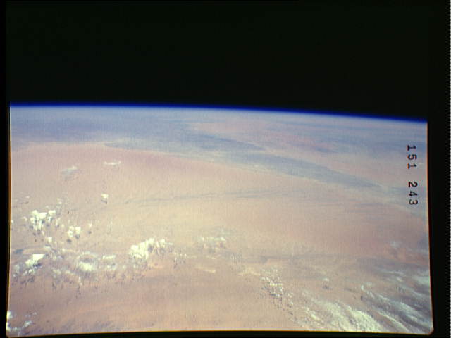
Country or Geographic Name: | ALGERIA |
Features: | GRAND ERG OCCIDENTAL |
| Features Found Using Machine Learning: | |
Cloud Cover Percentage: | 20 (11-25)% |
Sun Elevation Angle: | 72° |
Sun Azimuth: | 118° |
Camera: | Linhof |
Focal Length: | 90mm |
Camera Tilt: | High Oblique |
Format: | QX868: Kodak, natural color positive, Ektachrome QX868(5017 emulsion), ASA 64, thin base |
Film Exposure: | Normal |
| Additional Information | |
| Width | Height | Annotated | Cropped | Purpose | Links |
|---|---|---|---|---|---|
| 640 pixels | 480 pixels | No | No | ISD 1 | Download Image |
Download Packaged File
Download a Google Earth KML for this Image
View photo footprint information
Download a GeoTIFF for this photo
Image Caption: STS040-152-139 & STS040-151-243: African Dust
This African dust series is a good example of the vast amount of dust transported over the northern tropical Atlantic. Nadir-viewing Space Shuttle photography identifies the source points of dust over Algeria, Mali, and Mauritania, while oblique Space Shuttle photos and environmental satellite imagery show the horizontal coverage of the dust, stretching from the western Sahara Desert to the western Caribbean Sea. During STS-40, surface stations in Mali observed a horizontal visibility in dust of less than 1,000 meters (surface winds from the northeast with velocities of 16 knots).
This African dust series is a good example of the vast amount of dust transported over the northern tropical Atlantic. Nadir-viewing Space Shuttle photography identifies the source points of dust over Algeria, Mali, and Mauritania, while oblique Space Shuttle photos and environmental satellite imagery show the horizontal coverage of the dust, stretching from the western Sahara Desert to the western Caribbean Sea. During STS-40, surface stations in Mali observed a horizontal visibility in dust of less than 1,000 meters (surface winds from the northeast with velocities of 16 knots).
