STS040-151-116
| NASA Photo ID | STS040-151-116 |
| Focal Length | 90mm |
| Date taken | 1991.06.09 |
| Time taken | 15:13:25 GMT |

Cloud masks available for this image:
Spacecraft nadir point: 36.1° N, 115.8° W
Photo center point: 34.5° N, 116.5° W
Photo center point by machine learning:
Photo center point: 34.5° N, 116.5° W
Photo center point by machine learning:
Nadir to Photo Center: South
Spacecraft Altitude: 152 nautical miles (282km)
Country or Geographic Name: | USA-CALIFORNIA |
Features: | BARSTOW TO SALTON SEA |
| Features Found Using Machine Learning: | |
Cloud Cover Percentage: | 0 (no clouds present) |
Sun Elevation Angle: | 31° |
Sun Azimuth: | 82° |
Camera: | Linhof |
Focal Length: | 90mm |
Camera Tilt: | 35 degrees |
Format: | QX868: Kodak, natural color positive, Ektachrome QX868(5017 emulsion), ASA 64, thin base |
Film Exposure: | Normal |
| Additional Information | |
| Width | Height | Annotated | Cropped | Purpose | Links |
|---|---|---|---|---|---|
| 5056 pixels | 3968 pixels | No | No | Earth From Space collection | Download Image |
| 640 pixels | 502 pixels | No | No | Earth From Space collection | Download Image |
| 640 pixels | 480 pixels | No | No | ISD 1 | Download Image |
Download Packaged File
Download a Google Earth KML for this Image
View photo footprint information
Download a GeoTIFF for this photo
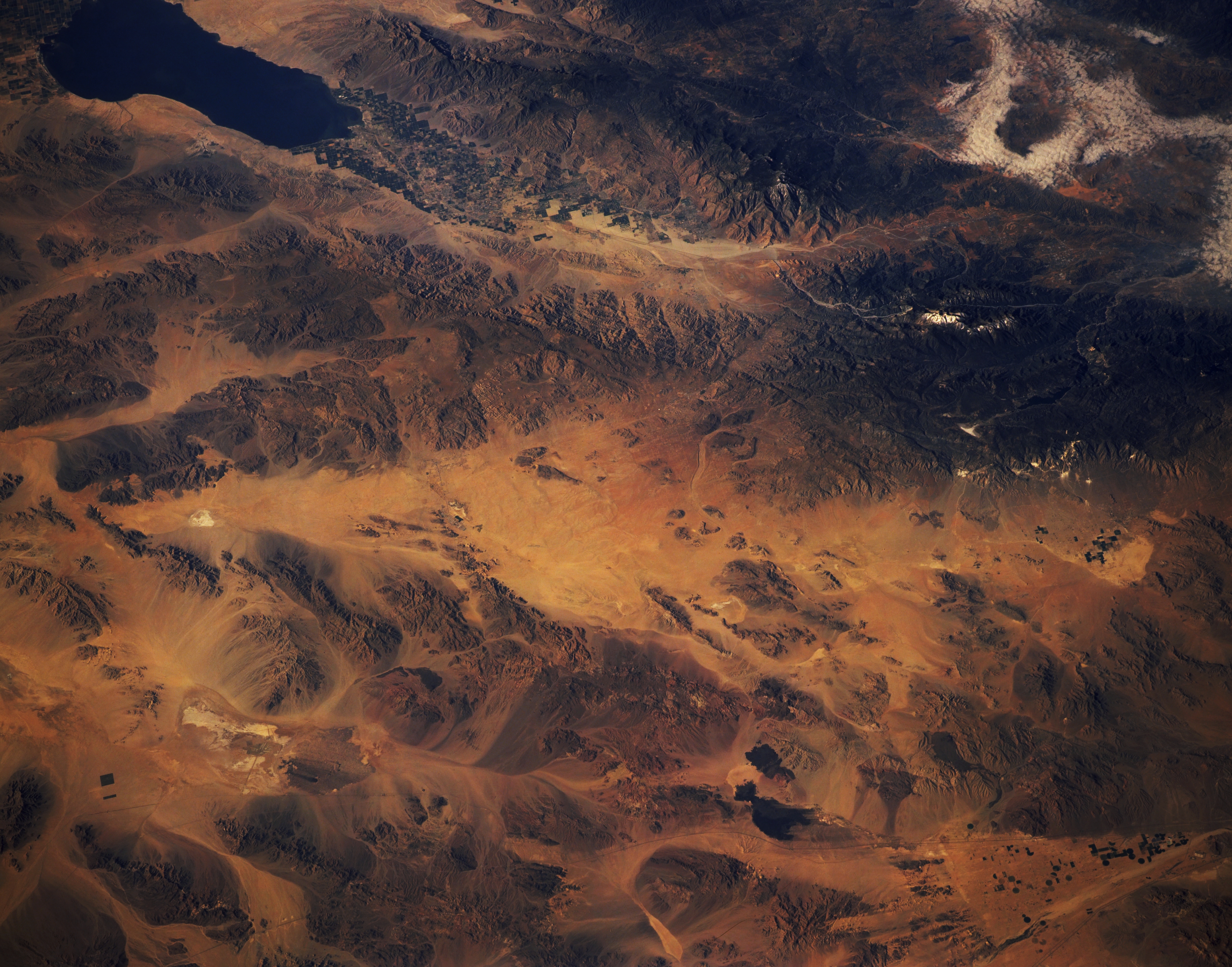
Image Caption: STS040-151-116 Southeastern California, U.S.A. June 1991
This southwest-looking, oblique photograph of southeastern California from the Salton Sea in the south to the southeastern Mojave Desert reveals the browns, tans, and yellows of this arid region. The only extensive area of vegetation lies in the cultivated northern Imperial Valley northwest of the Salton Sea. The dark, irrigated field patterns are barely discernible in the valley between the Santa Rosa Mountains (southwest of the valley) and the southeastern extension of the San Bernardino Mountains (north-northeast side of the valley). Mountains of various elevations and sizes stand in marked contrast with the sandy valleys between the ranges. The isolated, reflective white areas are dry lakebeds. The two darker, irregular features near the lower right side of the photograph are exposed lava beds.
This southwest-looking, oblique photograph of southeastern California from the Salton Sea in the south to the southeastern Mojave Desert reveals the browns, tans, and yellows of this arid region. The only extensive area of vegetation lies in the cultivated northern Imperial Valley northwest of the Salton Sea. The dark, irrigated field patterns are barely discernible in the valley between the Santa Rosa Mountains (southwest of the valley) and the southeastern extension of the San Bernardino Mountains (north-northeast side of the valley). Mountains of various elevations and sizes stand in marked contrast with the sandy valleys between the ranges. The isolated, reflective white areas are dry lakebeds. The two darker, irregular features near the lower right side of the photograph are exposed lava beds.
