STS040-151-115
| NASA Photo ID | STS040-151-115 |
| Focal Length | 90mm |
| Date taken | 1991.06.09 |
| Time taken | 15:13:12 GMT |

Cloud masks available for this image:
Spacecraft nadir point: 35.9° N, 116.8° W
Photo center point: 34.5° N, 116.0° W
Photo center point by machine learning:
Photo center point: 34.5° N, 116.0° W
Photo center point by machine learning:
Nadir to Photo Center: Southeast
Spacecraft Altitude: 152 nautical miles (282km)
Country or Geographic Name: | USA-CALIFORNIA |
Features: | AREA E. BARSTOW |
| Features Found Using Machine Learning: | |
Cloud Cover Percentage: | 0 (no clouds present) |
Sun Elevation Angle: | 30° |
Sun Azimuth: | 82° |
Camera: | Linhof |
Focal Length: | 90mm |
Camera Tilt: | 32 degrees |
Format: | QX868: Kodak, natural color positive, Ektachrome QX868(5017 emulsion), ASA 64, thin base |
Film Exposure: | Normal |
| Additional Information | |
| Width | Height | Annotated | Cropped | Purpose | Links |
|---|---|---|---|---|---|
| 5088 pixels | 3968 pixels | No | No | Earth From Space collection | Download Image |
| 640 pixels | 499 pixels | No | No | Earth From Space collection | Download Image |
| 640 pixels | 480 pixels | No | No | ISD 1 | Download Image |
Download Packaged File
Download a Google Earth KML for this Image
View photo footprint information
Download a GeoTIFF for this photo
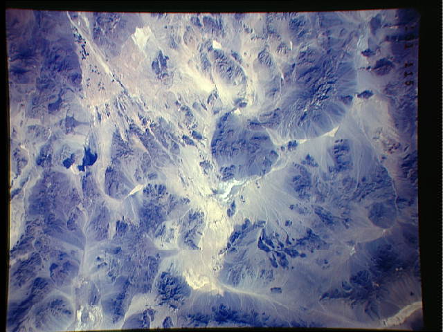
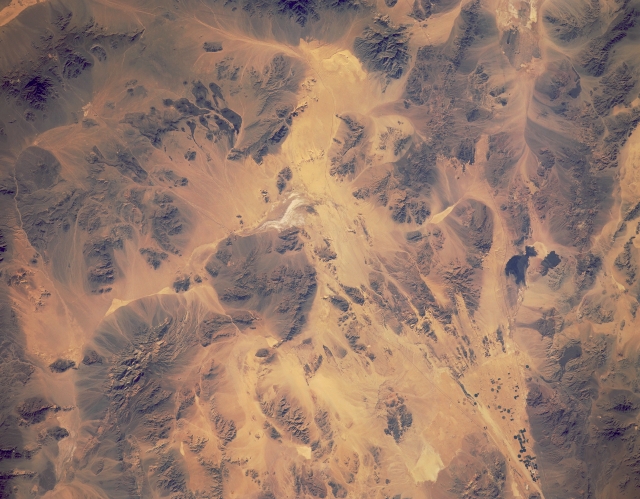
Image Caption: STS040-151-115 Mojave Desert, California, U.S.A. June 1991
Indications of human activity in this part of the Mojave Desert east of Barstow, California, are few. Some cultivated fields (small, darker areas) are visible within a triangular alluvial fan north of which lies Coyote Lake, a large, white dry lake. Interstate Highway 15, which connects Los Angeles, California, with Las Vegas, Nevada, and Interstate Highway 40 traversing California and Arizona appear as two thin, dark lines. The two larger, dark, irregular areas southeast of the fan are exposed lava beds. The remainder of the photograph shows eroding mountains and sandy intermontane valleys.
Indications of human activity in this part of the Mojave Desert east of Barstow, California, are few. Some cultivated fields (small, darker areas) are visible within a triangular alluvial fan north of which lies Coyote Lake, a large, white dry lake. Interstate Highway 15, which connects Los Angeles, California, with Las Vegas, Nevada, and Interstate Highway 40 traversing California and Arizona appear as two thin, dark lines. The two larger, dark, irregular areas southeast of the fan are exposed lava beds. The remainder of the photograph shows eroding mountains and sandy intermontane valleys.
