STS040-151-1
| NASA Photo ID | STS040-151-1 |
| Focal Length | 90mm |
| Date taken | 1991.06.07 |
| Time taken | 16:40:12 GMT |

Cloud masks available for this image:
Spacecraft nadir point: 36.7° N, 120.1° W
Photo center point: 36.0° N, 120.0° W
Photo center point by machine learning:
Photo center point: 36.0° N, 120.0° W
Photo center point by machine learning:
Nadir to Photo Center: South
Spacecraft Altitude: 153 nautical miles (283km)
Country or Geographic Name: | USA-CALIFORNIA |
Features: | SAN JOAQUIN VLY, FRESNO |
| Features Found Using Machine Learning: | |
Cloud Cover Percentage: | 30 (26-50)% |
Sun Elevation Angle: | 45° |
Sun Azimuth: | 93° |
Camera: | Linhof |
Focal Length: | 90mm |
Camera Tilt: | 15 degrees |
Format: | QX868: Kodak, natural color positive, Ektachrome QX868(5017 emulsion), ASA 64, thin base |
Film Exposure: | Normal |
| Additional Information | |
| Width | Height | Annotated | Cropped | Purpose | Links |
|---|---|---|---|---|---|
| 4000 pixels | 5120 pixels | No | No | Earth From Space collection | Download Image |
| 500 pixels | 640 pixels | No | No | Earth From Space collection | Download Image |
| 640 pixels | 480 pixels | No | No | ISD 1 | Download Image |
Download Packaged File
Download a Google Earth KML for this Image
View photo footprint information
Download a GeoTIFF for this photo
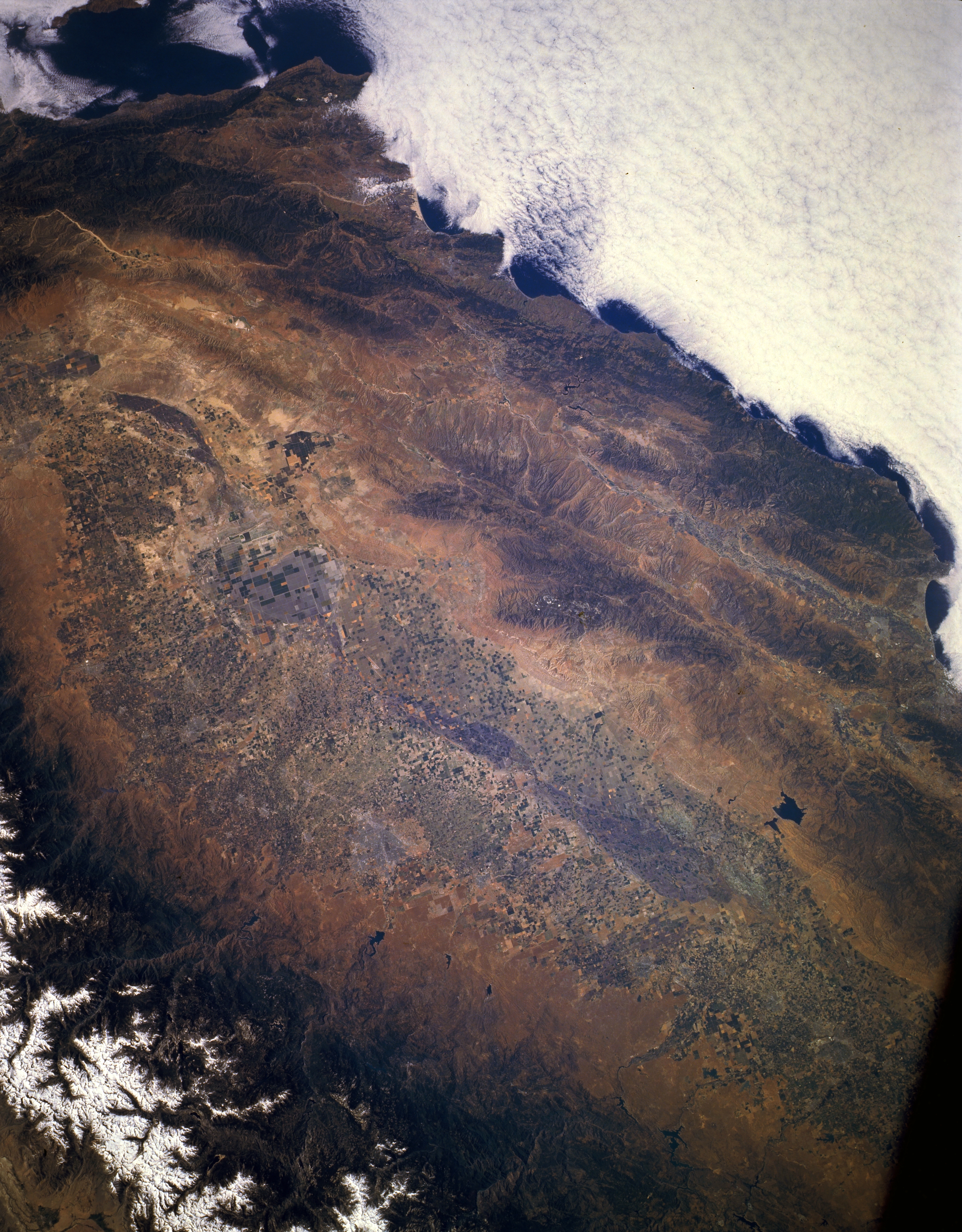
Image Caption: STS040-151-001 San Joaquin Valley and Coast Range, California, U.S.A. June 1991
A large part of the heavily cultivated San Joaquin Valley extending from Modesto in the north to Bakersfield in the south is visible in this low-oblique photograph. The broad valley and the Coast Range with several identifiable faulted valleys, including the San Andreas Fault, extend in a northwest-southeast alignment. Visible is a small section of the more massive, snow-capped Sierra Nevada Mountains along the eastern side of the valley. The small, irregular, black features along the western flank of the Sierra Nevada Mountains are reservoirs. The larger San Luis Reservoir is visible in the foothills of the Diablo Range along the western flank of the valley. Low stratus clouds hug the California coastline.
A large part of the heavily cultivated San Joaquin Valley extending from Modesto in the north to Bakersfield in the south is visible in this low-oblique photograph. The broad valley and the Coast Range with several identifiable faulted valleys, including the San Andreas Fault, extend in a northwest-southeast alignment. Visible is a small section of the more massive, snow-capped Sierra Nevada Mountains along the eastern side of the valley. The small, irregular, black features along the western flank of the Sierra Nevada Mountains are reservoirs. The larger San Luis Reservoir is visible in the foothills of the Diablo Range along the western flank of the valley. Low stratus clouds hug the California coastline.
