STS039-85-31
| NASA Photo ID | STS039-85-31 |
| Focal Length | 250mm |
| Date taken | 1991.04.30 |
| Time taken | 20:48:24 GMT |
Resolutions offered for this image:
3904 x 3904 pixels 639 x 639 pixels 5700 x 6000 pixels 500 x 526 pixels 640 x 480 pixels
3904 x 3904 pixels 639 x 639 pixels 5700 x 6000 pixels 500 x 526 pixels 640 x 480 pixels


Cloud masks available for this image:
Spacecraft nadir point: 33.6° N, 97.7° W
Photo center point: 32.7° N, 97.3° W
Photo center point by machine learning:
Photo center point: 32.7° N, 97.3° W
Photo center point by machine learning:
Nadir to Photo Center: South
Spacecraft Altitude: 140 nautical miles (259km)
Country or Geographic Name: | USA-TEXAS |
Features: | FT. WORTH-ARLINGTON |
| Features Found Using Machine Learning: | |
Cloud Cover Percentage: | 0 (no clouds present) |
Sun Elevation Angle: | 54° |
Sun Azimuth: | 243° |
Camera: | Hasselblad |
Focal Length: | 250mm |
Camera Tilt: | 23 degrees |
Format: | 5017: Kodak, natural color positive, Ektachrome, X Professional, ASA 64, standard base |
Film Exposure: | Normal |
| Additional Information | |
| Width | Height | Annotated | Cropped | Purpose | Links |
|---|---|---|---|---|---|
| 3904 pixels | 3904 pixels | No | No | Earth From Space collection | Download Image |
| 639 pixels | 639 pixels | No | No | Earth From Space collection | Download Image |
| 5700 pixels | 6000 pixels | No | No | Download Image | |
| 500 pixels | 526 pixels | No | No | Download Image | |
| 640 pixels | 480 pixels | No | No | Download Image |
Download Packaged File
Download a Google Earth KML for this Image
View photo footprint information
Download a GeoTIFF for this photo
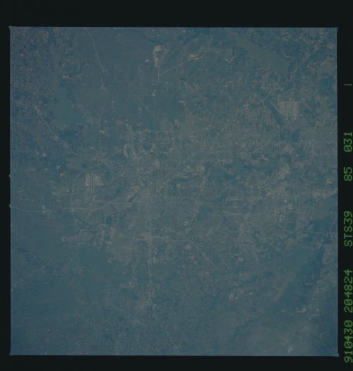
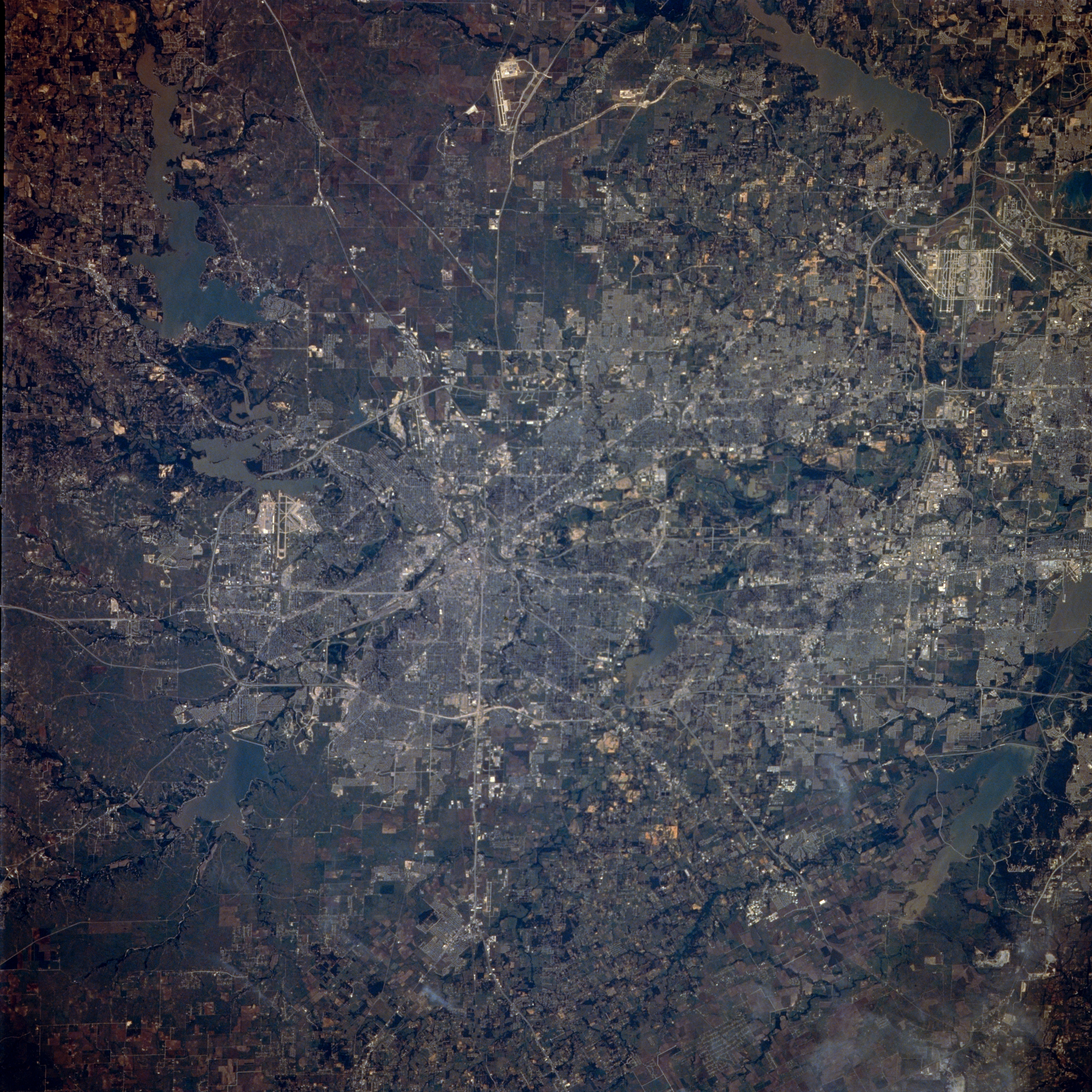
Image Caption: STS039-085-031 Fort Worth, Texas, U.S.A. May 1991
Metropolitan Fort Worth, built on the flat terrain of the grand prairie of north-central Texas, is featured in this photograph. The central business district is the highly reflective focal point for numerous roads that radiate outward. Visible are Interstate Highway 30, which traverses the center of the urban area; Interstate Highway 20, which follows the southern periphery of the urban subdivisions; the merging of the two highways west of the city and continuing as Interstate 20; and Interstate Highway 820, a major loop that skirts the west, northwest, and north sides of Fort Worth. Viewing clockwise from the upper right corner are seven lakes--Grapevine Lake, Mountain Creek Lake, Joe Pool Lake, Lake Arlington, Benbrook Lake, Lake Worth, and Eagle Mountain Lake. Visible are the runways of three airports--Alliance (north), Dallas-Fort Worth International (northeast), and Carswell Air Force Base (west of downtown).
Metropolitan Fort Worth, built on the flat terrain of the grand prairie of north-central Texas, is featured in this photograph. The central business district is the highly reflective focal point for numerous roads that radiate outward. Visible are Interstate Highway 30, which traverses the center of the urban area; Interstate Highway 20, which follows the southern periphery of the urban subdivisions; the merging of the two highways west of the city and continuing as Interstate 20; and Interstate Highway 820, a major loop that skirts the west, northwest, and north sides of Fort Worth. Viewing clockwise from the upper right corner are seven lakes--Grapevine Lake, Mountain Creek Lake, Joe Pool Lake, Lake Arlington, Benbrook Lake, Lake Worth, and Eagle Mountain Lake. Visible are the runways of three airports--Alliance (north), Dallas-Fort Worth International (northeast), and Carswell Air Force Base (west of downtown).
