STS039-85-16
| NASA Photo ID | STS039-85-16 |
| Focal Length | 250mm |
| Date taken | 1991.04.30 |
| Time taken | 17:45:40 GMT |
Resolutions offered for this image:
3904 x 3904 pixels 639 x 639 pixels 5700 x 6000 pixels 500 x 526 pixels 640 x 480 pixels
3904 x 3904 pixels 639 x 639 pixels 5700 x 6000 pixels 500 x 526 pixels 640 x 480 pixels


Cloud masks available for this image:
Spacecraft nadir point: 44.1° N, 64.6° W
Photo center point: 45.0° N, 64.5° W
Photo center point by machine learning:
Photo center point: 45.0° N, 64.5° W
Photo center point by machine learning:
Nadir to Photo Center: North
Spacecraft Altitude: 142 nautical miles (263km)
Country or Geographic Name: | CANADA-NS |
Features: | MINAS CHAN./BASIN, AGR. |
| Features Found Using Machine Learning: | |
Cloud Cover Percentage: | 0 (no clouds present) |
Sun Elevation Angle: | 55° |
Sun Azimuth: | 215° |
Camera: | Hasselblad |
Focal Length: | 250mm |
Camera Tilt: | 21 degrees |
Format: | 5017: Kodak, natural color positive, Ektachrome, X Professional, ASA 64, standard base |
Film Exposure: | Normal |
| Additional Information | |
| Width | Height | Annotated | Cropped | Purpose | Links |
|---|---|---|---|---|---|
| 3904 pixels | 3904 pixels | No | No | Earth From Space collection | Download Image |
| 639 pixels | 639 pixels | No | No | Earth From Space collection | Download Image |
| 5700 pixels | 6000 pixels | No | No | Download Image | |
| 500 pixels | 526 pixels | No | No | Download Image | |
| 640 pixels | 480 pixels | No | No | Download Image |
Download Packaged File
Download a Google Earth KML for this Image
View photo footprint information
Download a GeoTIFF for this photo
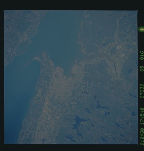
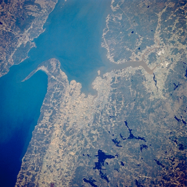
Image Caption: STS039-085-016 Minas Basin, Nova Scotia, Canada May 1991
The Minas Channel (west of pointed peninsula) and the Minas Basin (east of peninsula) are part of the eastern extension of the larger Bay of Fundy. Cape Split is located on the tip of the pointed peninsula that separates these two bodies of water. The tides in the Bay of Fundy are the highest in the world ranging more than 50 feet (15 meters) from low to high tide. The lighter colored landscape shows where the cultivated fields are located. The dark, irregular shaped features inland are lakes, a result of the continental ice sheets that covered Nova Scotia during the Pleistocene era, roughly 15000 to 18000 years ago.
The Minas Channel (west of pointed peninsula) and the Minas Basin (east of peninsula) are part of the eastern extension of the larger Bay of Fundy. Cape Split is located on the tip of the pointed peninsula that separates these two bodies of water. The tides in the Bay of Fundy are the highest in the world ranging more than 50 feet (15 meters) from low to high tide. The lighter colored landscape shows where the cultivated fields are located. The dark, irregular shaped features inland are lakes, a result of the continental ice sheets that covered Nova Scotia during the Pleistocene era, roughly 15000 to 18000 years ago.
