STS039-602-55

| NASA Photo ID | STS039-602-55 |
| Focal Length | 100mm |
| Date taken | 1991.04.29 |
| Time taken | 14:41:00 GMT |
Resolutions offered for this image:
3904 x 3904 pixels 639 x 639 pixels 5700 x 6000 pixels 500 x 526 pixels 640 x 480 pixels
3904 x 3904 pixels 639 x 639 pixels 5700 x 6000 pixels 500 x 526 pixels 640 x 480 pixels


Cloud masks available for this image:
Spacecraft nadir point: 53.9° N, 91.1° W
Photo center point: 54.0° N, 79.0° W
Photo center point by machine learning:
Photo center point: 54.0° N, 79.0° W
Photo center point by machine learning:
Nadir to Photo Center: East
Spacecraft Altitude: 138 nautical miles (256km)
Camera: | Rolleiflex |
Focal Length: | 100mm |
Camera Tilt: | High Oblique |
Format: | 5017: Kodak, natural color positive, Ektachrome, X Professional, ASA 64, standard base |
Film Exposure: | Under Exposed |
| Additional Information | |
| Width | Height | Annotated | Cropped | Purpose | Links |
|---|---|---|---|---|---|
| 3904 pixels | 3904 pixels | No | No | Earth From Space collection | Download Image |
| 639 pixels | 639 pixels | No | No | Earth From Space collection | Download Image |
| 5700 pixels | 6000 pixels | No | No | Download Image | |
| 500 pixels | 526 pixels | No | No | Download Image | |
| 640 pixels | 480 pixels | No | No | Download Image |
Download Packaged File
Download a Google Earth KML for this Image
View photo footprint information
Download a GeoTIFF for this photo
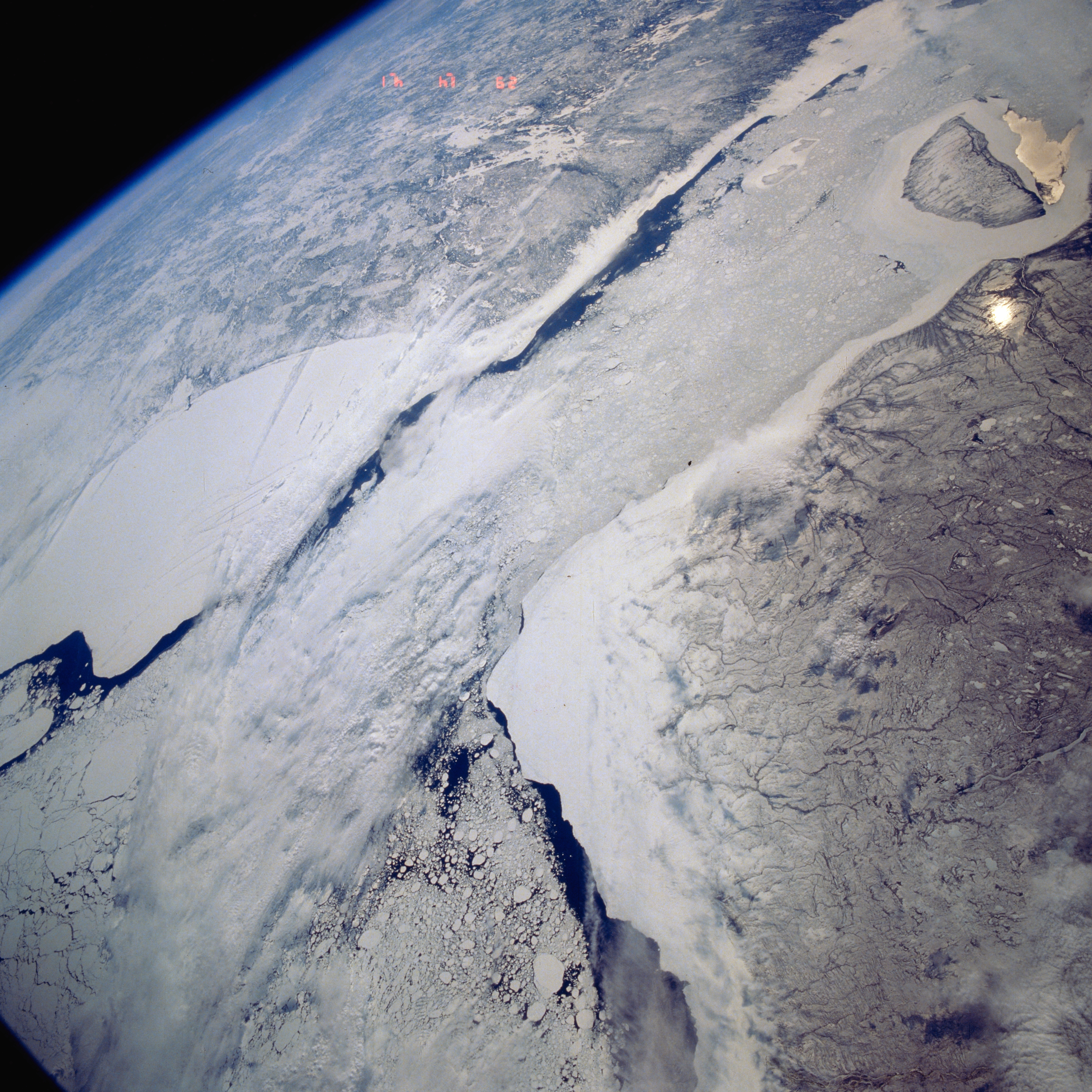
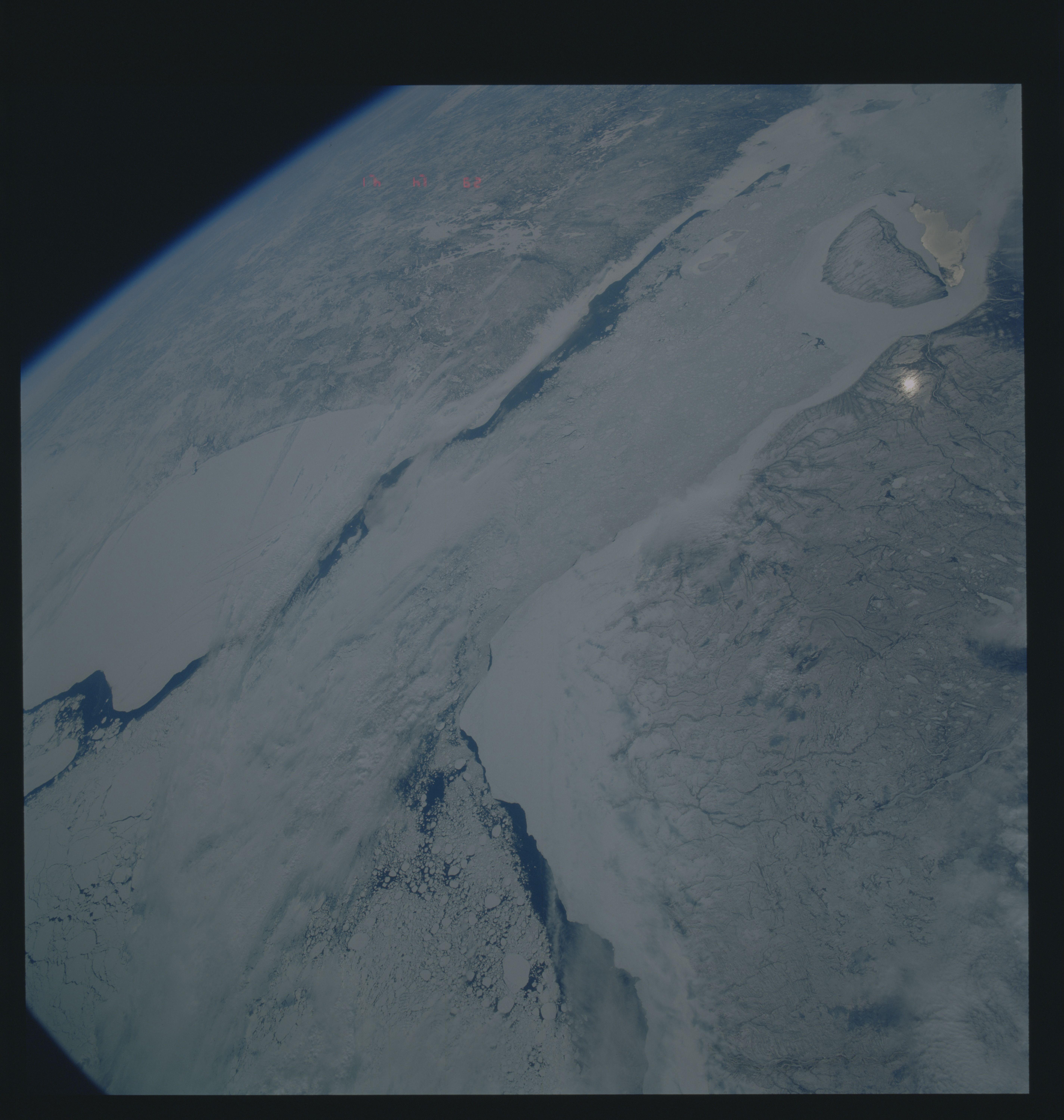
Image Caption: STS039-602-055 Hudson, James Bays, Canada May 1991
The southern end of Hudson Bay (lower left) and its southern extension James Bay (upper right), are visible in this southeast-looking view. Cloud cover partially obscures the different sized ice floes that can be found mainly in the south central section of Hudson Bay. The large, white, smooth-looking features east and west of the water are probably snow covered ice that are adjacent to the shorelines of Quebec (top) and Ontario (bottom). The dark areas within Hudson and James Bays show the extent of open water in spring (May). Akimiski Island is the island near the western side of James Bay (upper right corner).
The southern end of Hudson Bay (lower left) and its southern extension James Bay (upper right), are visible in this southeast-looking view. Cloud cover partially obscures the different sized ice floes that can be found mainly in the south central section of Hudson Bay. The large, white, smooth-looking features east and west of the water are probably snow covered ice that are adjacent to the shorelines of Quebec (top) and Ontario (bottom). The dark areas within Hudson and James Bays show the extent of open water in spring (May). Akimiski Island is the island near the western side of James Bay (upper right corner).
