STS039-151-175

| NASA Photo ID | STS039-151-175 |
| Focal Length | 250mm |
| Date taken | 1991.04.30 |
| Time taken | 20:49:20 GMT |
Resolutions offered for this image:
4044 x 5136 pixels 503 x 640 pixels 4960 x 3995 pixels 640 x 480 pixels 3239 x 4096 pixels 506 x 640 pixels
4044 x 5136 pixels 503 x 640 pixels 4960 x 3995 pixels 640 x 480 pixels 3239 x 4096 pixels 506 x 640 pixels


Cloud masks available for this image:
Spacecraft nadir point: 30.4° N, 94.8° W
Photo center point: 29.5° N, 95.5° W
Photo center point by machine learning:
Photo center point: 29.5° N, 95.5° W
Photo center point by machine learning:
Nadir to Photo Center: Southwest
Spacecraft Altitude: 139 nautical miles (257km)
Country or Geographic Name: | USA-TEXAS |
Features: | HOUSTON-GALVESTON AREA |
| Features Found Using Machine Learning: | |
Cloud Cover Percentage: | 5 (1-10)% |
Sun Elevation Angle: | 52° |
Sun Azimuth: | 250° |
Camera: | Linhof |
Focal Length: | 250mm |
Camera Tilt: | 26 degrees |
Format: | QX868: Kodak, natural color positive, Ektachrome QX868(5017 emulsion), ASA 64, thin base |
Film Exposure: | Normal |
| Additional Information | |
| Width | Height | Annotated | Cropped | Purpose | Links |
|---|---|---|---|---|---|
| 4044 pixels | 5136 pixels | No | No | Earth From Space collection | Download Image |
| 503 pixels | 640 pixels | No | No | Earth From Space collection | Download Image |
| 4960 pixels | 3995 pixels | No | No | Download Image | |
| 640 pixels | 480 pixels | No | No | ISD 1 | Download Image |
| 3239 pixels | 4096 pixels | No | No | Download Image | |
| 506 pixels | 640 pixels | No | No | Download Image |
Download Packaged File
Download a Google Earth KML for this Image
View photo footprint information
Download a GeoTIFF for this photo
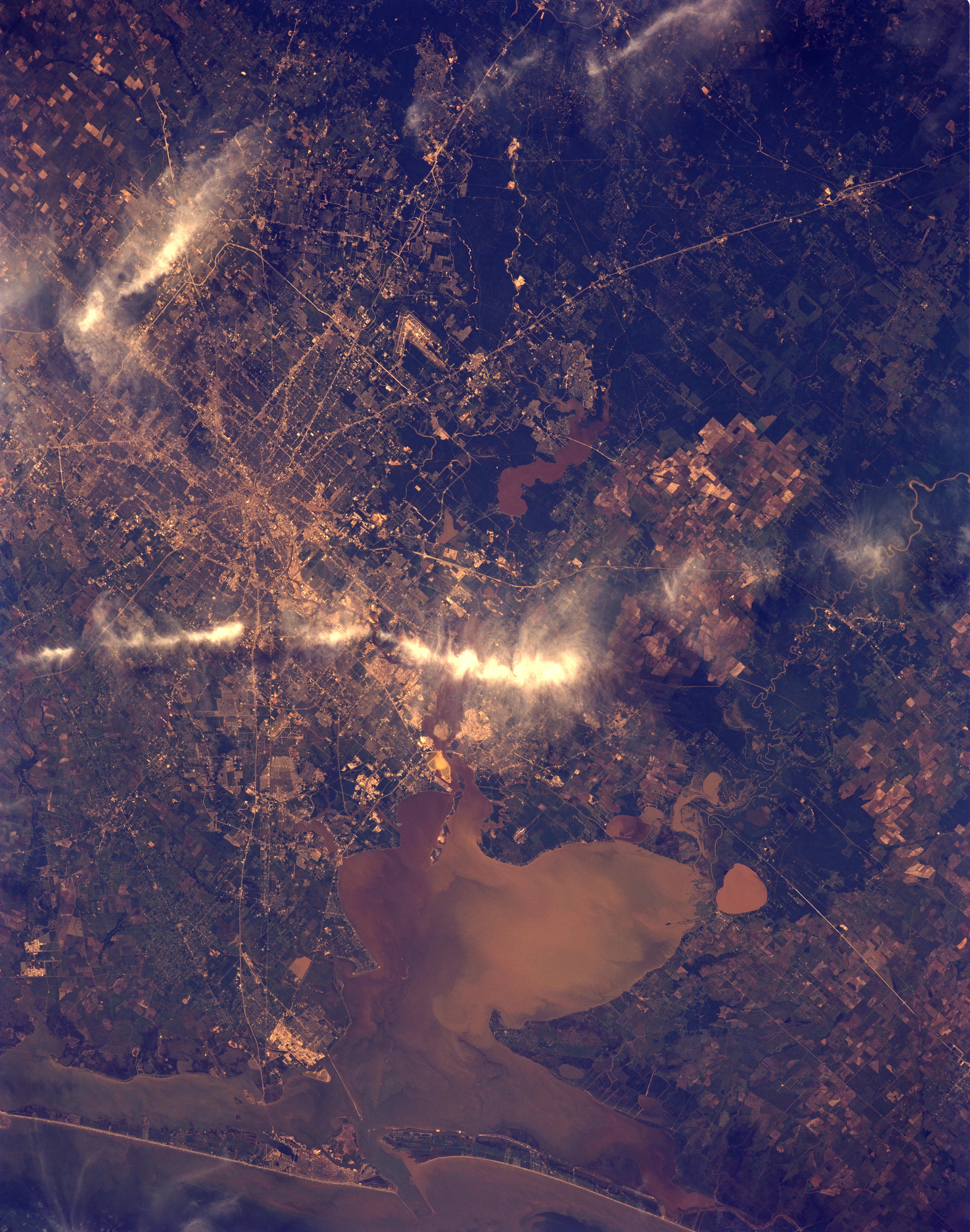
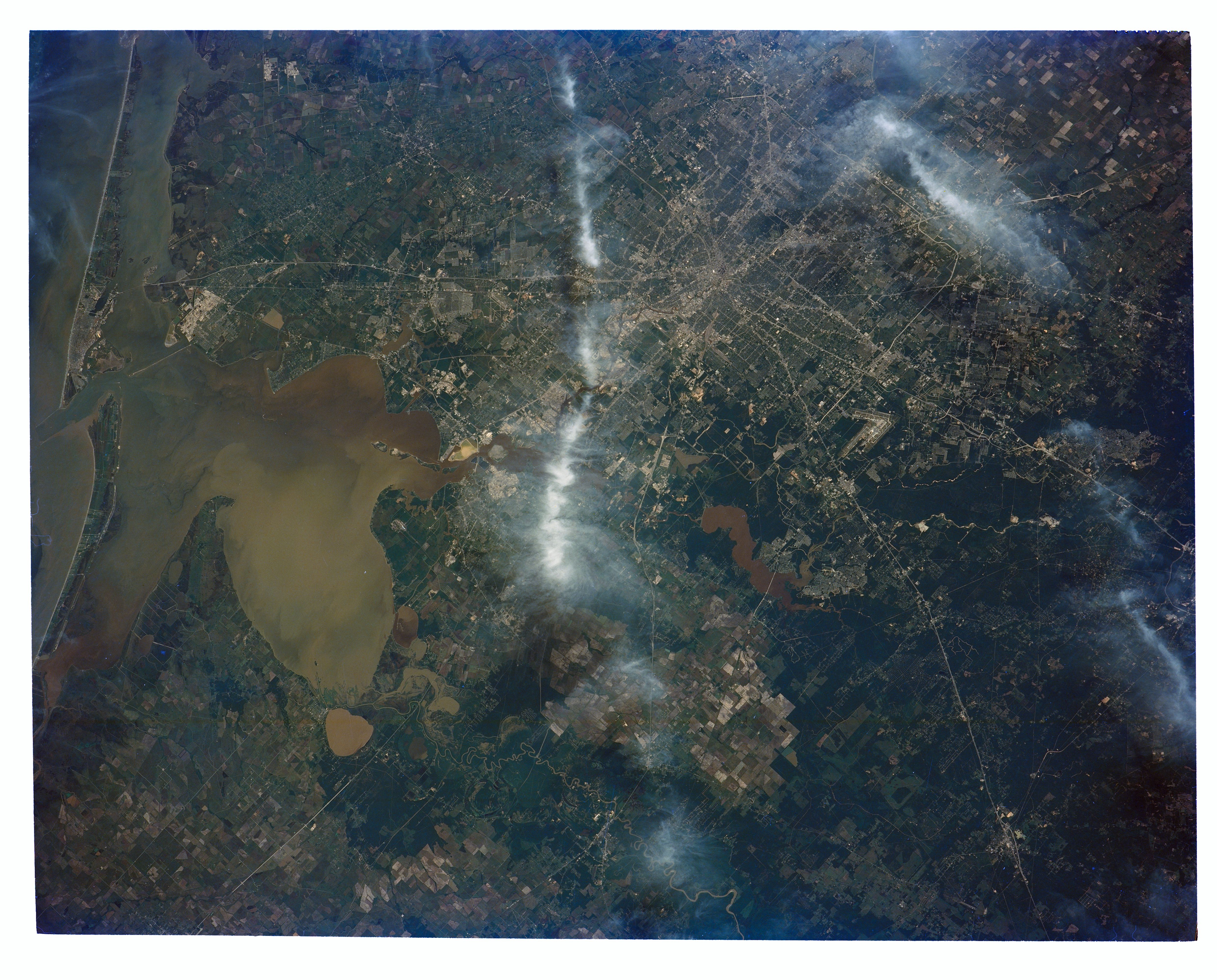
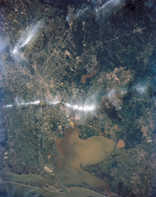
Image Caption: STS039-151-175 Houston, Texas, U.S.A. May 1991
Although two bands of clouds obscure part of this near-vertical photograph of metropolitan Houston, much urban infrastructure can be identified, such as Lake Houston (northeast of downtown), the source of most of the city's drinking water. Numerous major highways converge on the downtown central business district, and two beltways (the inner loop--Interstate Highway 610, and the outer loop--partially constructed Beltway 8) encircle the city. Highly reflective areas of concrete and metals indicate concentrations of industrial and commercial activities. One such corridor extending eastward to Galveston Bay from near downtown is the Houston Ship Channel, home to many chemical plants and oil refineries. Just north of the causeway linking Galveston Island with the mainland is Texas City, a major site for oil refining and chemical processing. Houston has three main airports--large, V-shaped Houston Intercontinental Airport (visible north of downtown), Ellington Field (visible southeast of downtown), and Hobby Airport (obscured by cloud cover southeast of downtown). Residential street patterns are discernible in many of the surrounding communities. NASA Lyndon B. Johnson Space Center is east of Interstate Highway 45 immediately northeast of Clear Lake. East of Houston cultivated fields of rice flank the Trinity River. Lake Anahuac is the small brown, roughly circular body of water just south of Interstate Highway 10. This photograph provides a visual record of the sediment characteristics and turbidity of Galveston Bay.
In this view of Houston/Galveston, Texas, USA (29.5N, 95.5W), heavy spring rains emphasize the several bodies of water in the area. The progressive nature of the Houston highway and freeway system can easily be observed in this highly detailed view. Houston Intercontiental Airport can be seen to the north and to the south, the NASA, Clear Lake area just off of Galveston Bay can easily be seen. In the center, is the downtown business district.
